Chesnee, South Carolina
| Chesnee, South Carolina | |
|---|---|
| City | |
 | |
 Location of Chesnee, South Carolina | |
| Coordinates: 35°8′54″N 81°51′43″W / 35.14833°N 81.86194°WCoordinates: 35°8′54″N 81°51′43″W / 35.14833°N 81.86194°W | |
| Country | United States |
| State | South Carolina |
| Counties | Spartanburg, Cherokee |
| Government | |
| • Mayor | Max Cash |
| Area | |
| • Total | 1.14 sq mi (2.94 km2) |
| • Land | 1.14 sq mi (2.94 km2) |
| • Water | 0.0 sq mi (0.0 km2) |
| Elevation | 892 ft (272 m) |
| Population (2010) | |
| • Total | 868 |
| • Density | 764/sq mi (294.8/km2) |
| Time zone | Eastern (EST) (UTC-5) |
| • Summer (DST) | EDT (UTC-4) |
| ZIP code | 29323 |
| Area code(s) | 864 |
| FIPS code | 45-14050[1] |
| GNIS feature ID | 1221550[2] |
| Website |
www |
Chesnee is a city in Spartanburg and Cherokee counties, in the U.S. state of South Carolina. The population was 868 as of the 2010 census.[3]
History
In the early 20th century, the Chesnee Land Company bought a sizeable acreage at what is now Chesnee. A leading member of the company was John B. Cleveland of Spartanburg. Cleveland named the company - and later the town - after his great-grandmother, Margaret Chesnee, who was born in Scotland. She married Alexander Vernon, also born in Scotland.[4] The Clinchfield Railroad ran an excursion train over the newly laid rails to Spartanburg on October 23, 1909.
The Chesnee post office was established in 1910,[5] and the town was chartered in 1911. Early businesses included a hotel, pharmacy, cotton mill, and lumber mill.[6]
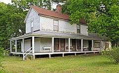
The Cowpens National Battlefield and Zeno Hicks House are listed on the National Register of Historic Places.[7]
Geography
Chesnee is located near the northeast corner of Spartanburg County, and a small part of the city extends east into Cherokee County. U.S. Route 221 passes through the city as Alabama Avenue and Hampton Street, leading north 18 miles (29 km) to Rutherfordton, North Carolina, and south 16 miles (26 km) to Spartanburg. South Carolina Highway 11 (Cherokee Street) crosses US 221 in the center of town and leads west 19 miles (31 km) to Campobello and east past Cowpens National Battlefield 14 miles (23 km) to Gaffney.
According to the United States Census Bureau, Chesnee has a total area of 1.14 square miles (2.94 km2), all land.[3]
Demographics
| Historical population | |||
|---|---|---|---|
| Census | Pop. | %± | |
| 1920 | 600 | — | |
| 1930 | 764 | 27.3% | |
| 1940 | 827 | 8.2% | |
| 1950 | 1,051 | 27.1% | |
| 1960 | 1,045 | −0.6% | |
| 1970 | 1,069 | 2.3% | |
| 1980 | 1,069 | 0.0% | |
| 1990 | 1,280 | 19.7% | |
| 2000 | 1,003 | −21.6% | |
| 2010 | 868 | −13.5% | |
| Est. 2015 | 899 | [8] | 3.6% |
As of the census[1] of 2000, there were 1,003 people, 396 households, and 239 families residing in the city. The population density was 1,116.4 people per square mile (430.3/km²). There were 460 housing units at an average density of 512.0 per square mile (197.3/km²). The racial makeup of the city was 68.20% White, 27.52% African American, 0.30% Native American, 0.10% Asian, 1.99% from other races, and 1.89% from two or more races. Hispanic or Latino of any race were 4.69% of the population.
There were 396 households out of which 26.3% had children under the age of 18 living with them, 39.6% were married couples living together, 17.7% had a female householder with no husband present, and 39.4% were non-families. 35.4% of all households were made up of individuals and 13.4% had someone living alone who was 65 years of age or older. The average household size was 2.43 and the average family size was 3.18.
In the city the population was spread out with 25.3% under the age of 18, 9.9% from 18 to 24, 26.8% from 25 to 44, 22.2% from 45 to 64, and 15.8% who were 65 years of age or older. The median age was 37 years. For every 100 females there were 87.8 males. For every 100 females age 18 and over, there were 77.9 males.
The median income for a household in the city was $25,089, and the median income for a family was $33,438. Males had a median income of $30,000 versus $17,500 for females. The per capita income for the city was $12,993. About 16.5% of families and 24.3% of the population were below the poverty line, including 37.6% of those under age 18 and 6.6% of those age 65 or over.
Local attractions
- Carolina Foothills Artisan Center
- Carolina Foothills Resort, a family-oriented nudist camp
- Cowpens National Battlefield
- HomeSpun Bluegrass, a twice-monthly live acoustic music show
- Strawberry Hill USA, a family farm offering tours and fresh produce
- Zeno Hicks House
Education
Public education is administered by Spartanburg County School District 2. Three schools are located in Chesnee, including Chesnee High School.
Notable people
- Woody Abernathy, repaired broadloom in Chesnee for 30 years after retiring from pitching with the New York Giants[10]
- Sonja Glenn, 1998 Miss South Carolina USA[11]
- Stephen Twitty, decorated U.S. Army major general[12]
References
- 1 2 "American FactFinder". United States Census Bureau. Archived from the original on 2013-09-11. Retrieved 2008-01-31.
- ↑ "US Board on Geographic Names". United States Geological Survey. 2007-10-25. Retrieved 2008-01-31.
- 1 2 "Geographic Identifiers: 2010 Census Summary File 1 (G001): Chesnee city, South Carolina". U.S. Census Bureau, American Factfinder. Retrieved June 30, 2015.
- ↑ Names in South Carolina, pp 136-137 (Claude Henry Neuffer, ed.) (1967) Columbia, SC: Department of English, University of South Carolina, based on A Brief History of the First Fifty Years of Chesnee, South Carolina, 1911-1961 by Helen Hicks Ezell.
- ↑ Helbock, Richard W. (2007) United States Post Offices, Volume VIII - The Southeast, p. 55, Scappoose, Oregon: La Posta Publications.
- ↑ "Chesnee, South Carolina". SCIWAY.net. Retrieved October 2013. Check date values in:
|access-date=(help) - ↑ National Park Service (2010-07-09). "National Register Information System". National Register of Historic Places. National Park Service.
- ↑ "Annual Estimates of the Resident Population for Incorporated Places: April 1, 2010 to July 1, 2015". Retrieved July 12, 2016.
- ↑ "Census of Population and Housing". Census.gov. Archived from the original on May 11, 2015. Retrieved June 4, 2015.
- ↑ "Virgil Abernathy". Spartanburg Herald-Journal. Dec 7, 1994.
- ↑ "Miss Massachusetts Crowned the Winner". Spartanburg Herald-Journal. March 11, 1998.
- ↑ Burge, David (May 27, 2013). "Departing Brig. Gen. Stephen Twitty recalls his troops". El Paso Times.
External links
- City of Chesnee official website
- Governmental information on City of Chesnee
- History and community information about Chesnee
- Spartanburg School District 2
Municipalities and communities of Spartanburg County, South Carolina, United States | ||
|---|---|---|
| Cities | 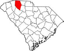 | |
| Towns | ||
| CDPs | ||
| Unincorporated communities | ||
| Ghost town | ||
| Footnotes | ‡This populated place also has portions in an adjacent county or counties | |
Municipalities and communities of Cherokee County, South Carolina, United States | ||
|---|---|---|
| Cities |  | |
| Towns | ||
| CDP | ||
| Unincorporated communities | ||
| Ghost town | ||
| Footnotes | ‡This populated place also has portions in an adjacent county or counties | |