Chelyabinsk Oblast
| Chelyabinsk Oblast Челябинская область (Russian) | |||
|---|---|---|---|
| — Oblast — | |||
| |||
|
| |||
| |||
|
| |||
| Political status | |||
| Country | Russia | ||
| Federal district | Urals[1] | ||
| Economic region | Urals[2] | ||
| Established | January 17, 1934 | ||
| Administrative center | Chelyabinsk | ||
| Government (as of January 2014) | |||
| • Governor[3] | Boris Dubrovsky (acting)[4] | ||
| • Legislature | Legislative Assembly[5] | ||
| Statistics | |||
| Area (as of the 2002 Census)[6] | |||
| • Total | 87,900 km2 (33,900 sq mi) | ||
| Area rank | 36th | ||
| Population (2010 Census)[7] | |||
| • Total | 3,476,217 | ||
| • Rank | 9th | ||
| • Density[8] | 39.55/km2 (102.4/sq mi) | ||
| • Urban | 82.0% | ||
| • Rural | 18.0% | ||
| Time zone(s) | YEKT (UTC+05:00)[9] | ||
| ISO 3166-2 | RU-CHE | ||
| License plates | 74, 174 | ||
| Official languages | Russian[10] | ||
| Official website | |||
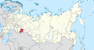
Chelyabinsk Oblast (Russian: Челя́бинская о́бласть, Chelyabinskaya oblast) is a federal subject (an oblast) of Russia in the Ural Mountains region, on the border of Europe and Asia.[11][12][13][14] Its administrative center is the city of Chelyabinsk. Population: 3,476,217 (2010 Census).[7]
History
During the Middle Ages, the Southern Urals were populated by Bashkir tribes that were part of the Golden Horde, Nogai Horde, and smaller Bashkir unions. The area was incorporated into the Tsardom of Russia in the late 16th century. However, Russian colonization of the region only began in the 18th century, with the establishment of a system of fortresses and trade posts on the then-Russian border by the Orenburg Expedition in 1734. Many cities of Chelyabinsk Oblast, including the city of Chelyabinsk itself, trace their history back to those forts.
In 1743, the Chelyabinsk fortress became a center of the Iset Province, a constituent part of the Orenburg Governorate (a direct successor of the Orenburg Expedition). The 1750s-1770s saw the emergence of industrial enterprises in South Ural, when the first factory-centered towns like Miass, Kyshtym, and Zlatoust were founded. After South Ural recovered from the Pugachev's Rebellion, the territory of modern-day Chelyabinsk Oblast started to attract more people from the European part of Russia. By the mid-19th century, Chelyabinsk was a major trade center in Ural, and after the construction of the Trans-Siberian Railway in the 1890s it became an important transport hub that connected Siberia to the rest of the Russian Empire.
In 1919, Chelyabinski became the regional capital of the newly formed Chelyabinsk Governorate, which combined eastern portions of the Orenburg Governorate with Kurgan of the Tobolsk Governorate. At this time, the population of the new region already exceeded one million people. In 1923, together with the Perm, Yekaterinburg and Tyumen governorates, it was merged into a single Ural Oblast that lasted less than ten years, until 1934. On January 17, 1934, Chelyabinsk Oblast was finally established. Its current boundaries were formed when Kurgan Oblast was detached from it in 1943.
Soviet industrialization
During the 1930s, the regional economy and industrial output grew as Chelyabinsk Oblast became a key focus of the first Five-Year Plans. Key factories and enterprises that formed the core of the modern Chelyabinsk economy, including the Magnitogorsk Iron and Steel Works, the Chelyabinsk Tractor Plant and the Chelyabinsk Metallurgical Plant, were founded at this time. The economy continued to grow with the outbreak of the Great Patriotic War, as industries were evacuated from the western parts of the Soviet Union to Ural, and Chelyabinsk Oblast in particular. During the war, Magnitogorsk alone produced one third of all Soviet steel, while the city of Chelyabinsk became the main center of Soviet tank production, earning the nickname "Tankograd" (Tank City).
Nuclear research
Chelyabinsk Oblast has been associated with top-secret nuclear research since the 1940s. While there are no nuclear power stations in Chelyabinsk, a number of production reactors were located there starting with the early Cold War. A serious nuclear accident occurred in 1957 at the Mayak nuclear fuel reprocessing plant, 150 km north-west of the city, which led to evacuations and fatalities throughout the Oblast, although not in Chelyabinsk city. The province was closed to all foreigners until 1992, with the sole exception of allowing a British medical team following a two-train rail explosion in the mid-1980s.
The documentary Chelyabinsk: The Most Contaminated Spot on the Planet was made by Slawomir Grunberg about the unsafe dumping of radioactive waste in the Techa River and Lake Karachay.
Geography

Chelyabinsk Oblast is on the eastern slope of the Southern Urals. Only a small part of the territory to the west is on the western slopes of the Southern Urals.
Chelyabinsk Oblast is situated in the Southern Urals, near Kurgan and Sverdlovsk oblast. Most of the Oblast is located to the east of the Ural Mountains, which form the continental boundary between Europe and Asia. This boundary is marked by a stone pillar at the Uraltau pass near the Urzhumka station (8 km from Zlatoust), which has "Europe" written on one side and "Asia" on the other. In Chelyabinsk Oblast, Zlatoust city, Katav-Ivanovsk, and Satka are located in Europe, while Chelyabinsk, Troitsk, and Miass are in Asia. Magnitogorsk is located on both continents.[15]
The area of Chelyabinsk Oblast is 88,900 km2.[16] The total length of its external border is 2750 km, and the Oblast measures 400 km from north to south and 490 km from west to east.
Relief
Chelyabinsk Oblast has a very diverse landscape, ranging from lowlands and hilly plains to mountain ranges with peaks exceeding 1,000 m, including Nurgush mountain (1406 m). The mountainous area has several ski resorts.
The West Siberian Plain is bounded on the west horizontal (elevation 190 m above sea level), which passes through the village of Bagaryak, Kunashak and continues through Chelyabinsk to the south. The lowlands are located in the northeast, and the elevation drops to 130 m in the eastern border region.
Hydrology
Numerous rivers, including the Kama, Tobol and Ural, originate within the region. The region is home to 348 rivers longer than 10 km (totaling 10,235 km in length), 17 of which are over 100 km in length. Seven rivers, the Miass, Uy, Ural, Ay, Ufa, Uvelka, and Gumbeyka, pass through the area and are longer than 200 km.
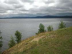
Chelyabinsk Oblast is also home to more than 3,748 lakes, mostly located in the north and east and covering a total area of 2125 km2. Many of the lakes in this area, including Lake Turgoyak, Zyuratkul, and Lake Itkul, are famous for their clear waters and attract tourism. Some of the lakes in the eastern foothills have tectonic origins as water accumulated in tectonic failures (basins), resulting in very deep lakes that can reach 30–40 m.

Politics
During the Soviet period, the highest authority in the Oblast was shared between three positions: the First Secretary of the Chelyabinsk CPSU Committee (who held the most power), the Chairman of the Oblast Soviet (legislative power), and the Chairman of the Oblast Executive Committee (executive power). Since the dissolution of the Soviet Union in 1991, the CPSU lost its monopoly on power.
Today, the Charter of Chelyabinsk Oblast governs the political structure of the region. The Legislative Assembly of Chelyabinsk Oblast serves as the province's regional parliament and exercises legislative authority, with the power to pass laws, resolutions, and other legal acts and oversee their implementation and observance. The Oblast Government, led by the Governor, is the highest executive body in the region, and includes territorial executive bodies such as district administrations, committees, and commissions that facilitate development and run the day-to-day matters of the province.
Administrative divisions
Demographics

Population: 3,476,217 (2010 Census);[7] 3,603,339 (2002 Census);[17] 3,623,732 (1989 Census).[18]
Chelyabinsk Oblast is highly urbanized.
According to the 2010 Census, the Oblast's ethnic composition was:[7]
- 2,829,899 Russians (83.8%);
- 180,913 Tatars (5.4%);
- 162,513 Bashkirs (4.8%);
- 50,081 Ukrainians (1.5%);
- 35,297 Kazakhs (1.00%);
- 18,687 Germans (0.5%);
- 13,035 Belarusians (0.4%);
- 12,147 Mordvins (0.2%);
- 9,311 Armenians (0.3%);
- 65,190 others (1.6);
- 99,144 people were registered from administrative databases, and could not declare an ethnicity. It is estimated that the proportion of ethnicities in this group is the same as that of the declared group.[16]
- Births (2011): 47,300 (13.6 per 1000)
- Deaths (2011): 49,469 (14.2 per 1000)[19]
- Vital statistics for 2012[20]
- Births: 49 885 (14.3 per 1000)
- Deaths: 49 367 (14.2 per 1000)
Total fertility rate:[21]
2009 - 1.63 | 2010 - 1.65 | 2011 - 1.70 | 2012 - 1.81 | 2013 - 1.80 | 2014 - 1.86 | 2015 - 1.85(e)
Religion

According to a 2012 official survey,[22] 30.9% of the population of Chelyabinsk Oblast adheres to the Russian Orthodox Church, 8% are unaffiliated generic Christians, 5% adheres to other Orthodox Churches, 8% of the population is Muslim, 1% adheres to Slavic Rodnovery (Slavic Neopaganism), and 0.4% to forms of Hinduism (Vedism, Krishnaism or Tantrism). In addition, 29% of the population deems itself to be "spiritual but not religious", 14% is atheist, and 4.7% follows other religions or did not give an answer to the question.[22]
2013 meteor
On February 15, 2013, a 10,000 ton meteoroid entered the Earth's atmosphere over Russia at about 09:20 YEKT (03:20 UTC). It passed over the southern Ural region and exploded in an air burst over Chelyabinsk Oblast. About 1,500 people were reported injured, including 311 children. Health officials said 112 people had been hospitalized, mainly from injuries caused by glass from windows shattered by a shock wave; two were reported to be in serious condition. As many as 3,000 buildings in six cities across the region were damaged by the explosion and impacts. The meteor created a dazzling light as it air burst, bright enough to cast shadows during broad daylight in Chelyabinsk.
Vital statistics for 2008
Source:[24]
| District (2008) | Type | Births | Deaths | NG | BR | DR | NGR |
|---|---|---|---|---|---|---|---|
| Chelyabinsk Oblast | Obl | 44931 | 52625 | -7694 | 12.8 | 15.0 | -0.22% |
| Urban Areas | Obl | 34550 | 41787 | -7237 | 12.1 | 14.6 | -0.25% |
| Rural Areas | Obl | 10381 | 10838 | -457 | 15.9 | 16.6 | -0.07% |
| Chelyabinsk | Urb | 12540 | 14192 | -1652 | 11.5 | 13.0 | -0.15% |
| Verkhny Ufaley | Urb | 516 | 727 | -211 | 13.6 | 19.1 | -0.55% |
| Zlatoust | Urb | 2111 | 2658 | -547 | 11.1 | 13.9 | -0.28% |
| Karabash | Urb | 227 | 262 | -35 | 14.5 | 16.7 | -0.22% |
| Kopeysk | Urb | 1737 | 2476 | -739 | 12.5 | 17.8 | -0.53% |
| Kyshtym | Urb | 535 | 695 | -160 | 12.5 | 16.2 | -0.37% |
| Lokomotivny | Urb | 117 | 41 | 76 | 11.8 | 4.1 | 0.77% |
| Magnitogorsk | Urb | 5276 | 6112 | -836 | 12.9 | 14.9 | -0.20% |
| Miass | Urb | 2289 | 2559 | -270 | 13.7 | 15.3 | -0.16% |
| Ozyorsk | Urb | 912 | 1312 | -400 | 9.2 | 13.2 | -0.40% |
| Snezhinsk | Urb | 544 | 586 | -42 | 10.8 | 11.6 | -0.08% |
| Tryokhgorny | Urb | 402 | 338 | 64 | 11.7 | 9.8 | 0.19% |
| Troitsk | Urb | 1085 | 1269 | -184 | 13.2 | 15.4 | -0.22% |
| Ust-Katav | Urb | 318 | 515 | -197 | 11.3 | 18.2 | -0.69% |
| Chebarkul | Urb | 550 | 698 | -148 | 12.7 | 16.2 | -0.35% |
| Yuzhnouralsk | Urb | 428 | 602 | -174 | 11.1 | 15.6 | -0.45% |
| Agapovsky | Rur | 649 | 513 | 136 | 18.5 | 14.6 | 0.39% |
| Argayashsky | Rur | 831 | 671 | 160 | 19.7 | 15.9 | 0.38% |
| Ashinsky | Rur | 831 | 1286 | -455 | 12.6 | 19.5 | -0.69% |
| Bredinsky | Rur | 485 | 480 | 5 | 15.6 | 15.4 | 0.02% |
| Varnensky | Rur | 460 | 453 | 7 | 15.9 | 15.7 | 0.02% |
| Verkhneuralsky | Rur | 575 | 743 | -168 | 13.6 | 17.6 | -0.40% |
| Yemanzhelinsky | Rur | 648 | 923 | -275 | 12.2 | 17.3 | -0.51% |
| Yetkulsky | Rur | 443 | 466 | -23 | 14.7 | 15.5 | -0.08% |
| Kartalinsky | Rur | 702 | 809 | -107 | 14.1 | 16.2 | -0.21% |
| Kaslinsky | Rur | 461 | 758 | -297 | 12.0 | 19.7 | -0.77% |
| Katav-Ivanovsky | Rur | 448 | 709 | -261 | 12.8 | 20.2 | -0.74% |
| Kizilsky | Rur | 432 | 400 | 32 | 16.2 | 15.0 | 0.12% |
| Korkinsky | Rur | 900 | 1256 | -356 | 13.8 | 19.3 | -0.55% |
| Krasnoarmeysky | Rur | 638 | 754 | -116 | 14.6 | 17.3 | -0.27% |
| Kunashaksky | Rur | 521 | 549 | -28 | 17.6 | 18.6 | -0.10% |
| Kusinsk | Rur | 420 | 535 | -115 | 13.9 | 17.7 | -0.38% |
| Nagaybaksky | Rur | 334 | 392 | -58 | 15.0 | 17.7 | -0.27% |
| Nyazepetrovsky | Rur | 298 | 433 | -135 | 14.6 | 21.3 | -0.67% |
| Oktyabrsky | Rur | 419 | 398 | 21 | 15.6 | 14.8 | 0.08% |
| Plastovsky | Rur | 450 | 453 | -3 | 17.2 | 17.3 | -0.01% |
| Satkinsky | Rur | 1230 | 1398 | -168 | 14.2 | 16.1 | -0.19% |
| Sosnovsky | Rur | 942 | 933 | 9 | 16.0 | 15.8 | 0.02% |
| Troitsky | Rur | 529 | 506 | 23 | 17.1 | 16.3 | 0.08% |
| Uvelsky | Rur | 508 | 533 | -25 | 16.1 | 16.9 | -0.08% |
| Uysky | Rur | 385 | 387 | -2 | 14.6 | 14.7 | -0.01% |
| Chebarkulsky | Rur | 494 | 538 | -44 | 16.6 | 18.1 | -0.15% |
| Chesmensky | Rur | 311 | 307 | 4 | 15.5 | 15.3 | 0.02% |
See also
References
- ↑ Президент Российской Федерации. Указ №849 от 13 мая 2000 г. «О полномочном представителе Президента Российской Федерации в федеральном округе». Вступил в силу 13 мая 2000 г. Опубликован: "Собрание законодательства РФ", №20, ст. 2112, 15 мая 2000 г. (President of the Russian Federation. Decree #849 of May 13, 2000 On the Plenipotentiary Representative of the President of the Russian Federation in a Federal District. Effective as of May 13, 2000.).
- ↑ Госстандарт Российской Федерации. №ОК 024-95 27 декабря 1995 г. «Общероссийский классификатор экономических регионов. 2. Экономические районы», в ред. Изменения №5/2001 ОКЭР. (Gosstandart of the Russian Federation. #OK 024-95 December 27, 1995 Russian Classification of Economic Regions. 2. Economic Regions, as amended by the Amendment #5/2001 OKER. ).
- ↑ Charter, Article 8.4
- ↑ Official website of the Governor of Chelyabinsk Oblast. Boris Alexandrovich Dubrovsky, Acting Governor of Chelyabinsk Oblast
- ↑ Charter, Article 8.3-1
- ↑ Федеральная служба государственной статистики (Federal State Statistics Service) (2004-05-21). "Территория, число районов, населённых пунктов и сельских администраций по субъектам Российской Федерации (Territory, Number of Districts, Inhabited Localities, and Rural Administration by Federal Subjects of the Russian Federation)". Всероссийская перепись населения 2002 года (All-Russia Population Census of 2002) (in Russian). Federal State Statistics Service. Retrieved 2011-11-01.
- 1 2 3 4 Russian Federal State Statistics Service (2011). "Всероссийская перепись населения 2010 года. Том 1" [2010 All-Russian Population Census, vol. 1]. Всероссийская перепись населения 2010 года (2010 All-Russia Population Census) (in Russian). Federal State Statistics Service. Retrieved June 29, 2012.
- ↑ The density value was calculated by dividing the population reported by the 2010 Census by the area shown in the "Area" field. Please note that this value may not be accurate as the area specified in the infobox is not necessarily reported for the same year as the population.
- ↑ Правительство Российской Федерации. Федеральный закон №107-ФЗ от 3 июня 2011 г. «Об исчислении времени», в ред. Федерального закона №271-ФЗ от 03 июля 2016 г. «О внесении изменений в Федеральный закон "Об исчислении времени"». Вступил в силу по истечении шестидесяти дней после дня официального опубликования (6 августа 2011 г.). Опубликован: "Российская газета", №120, 6 июня 2011 г. (Government of the Russian Federation. Federal Law #107-FZ of June 31, 2011 On Calculating Time, as amended by the Federal Law #271-FZ of July 03, 2016 On Amending Federal Law "On Calculating Time". Effective as of after sixty days following the day of the official publication.).
- ↑ Official on the whole territory of Russia according to Article 68.1 of the Constitution of Russia.
- ↑ "Investing in Chelyabinsk city - Invest in Russia". Unvestunrussia.biz. Retrieved June 9, 2016.
- ↑ "On cooperation between the Chelyabinsk region and Japan" (PDF). Rotobo.or.jp. Retrieved June 9, 2016.
- ↑ "Invest in Ural". Investunural.com. Retrieved June 9, 2016.
- ↑ "Guide to Investment : Chelyabinsk Region" (PDF). Econom-chelrug.ru. Retrieved June 9, 2016.
- ↑ "Magnitogorsk - is our city in the Urals". City of Magnitogorsk. August 24, 2012. Retrieved June 12, 2016.
- 1 2 "ВПН-2010". Perepis-2010.ru. Retrieved June 9, 2016.
- ↑ Russian Federal State Statistics Service (May 21, 2004). "Численность населения России, субъектов Российской Федерации в составе федеральных округов, районов, городских поселений, сельских населённых пунктов – районных центров и сельских населённых пунктов с населением 3 тысячи и более человек" [Population of Russia, Its Federal Districts, Federal Subjects, Districts, Urban Localities, Rural Localities—Administrative Centers, and Rural Localities with Population of Over 3,000] (XLS). Всероссийская перепись населения 2002 года [All-Russia Population Census of 2002] (in Russian). Retrieved August 9, 2014.
- ↑ Demoscope Weekly (1989). "Всесоюзная перепись населения 1989 г. Численность наличного населения союзных и автономных республик, автономных областей и округов, краёв, областей, районов, городских поселений и сёл-райцентров" [All Union Population Census of 1989: Present Population of Union and Autonomous Republics, Autonomous Oblasts and Okrugs, Krais, Oblasts, Districts, Urban Settlements, and Villages Serving as District Administrative Centers]. Всесоюзная перепись населения 1989 года [All-Union Population Census of 1989] (in Russian). Институт демографии Национального исследовательского университета: Высшая школа экономики [Institute of Demography at the National Research University: Higher School of Economics]. Retrieved August 9, 2014.
- ↑
- ↑ "Естественное движение населения в разрезе субъектов Российской Федерации". Gks.ru. Retrieved June 9, 2016.
- ↑ "Каталог публикаций::Федеральная служба государственной статистики". Gks.ru. Retrieved June 9, 2016.
- 1 2 3 "Главная страница проекта "Арена"". Sreda.org. October 19, 2012. Retrieved June 9, 2016.
- ↑ 2012 Survey Maps. "Ogonek", № 34 (5243), 27/08/2012. Retrieved September 24, 2012.
- ↑
Sources
- Законодательное Собрание Челябинской области. Закон №22-ЗО от 25 мая 2006 г. «Устав (основной закон) Челябинской области», в ред. Закона №427-ЗО от 30 апреля 2009 г. (Legislative Assembly of Chelyabinsk Oblast. Law #22-ZO of May 25, 2006 Charter (Basic Law) of Chelyabinsk Oblast, as amended by the Law #427-ZO of April 30, 2009. ).
External links
| Wikimedia Commons has media related to Chelyabinsk Oblast. |
| |||||||||||||||||||||||||||||||
| |||||||||||||||||||||||||||||||
 |
|
|
| |
| |
|
Kostanay Province, | ||
| ||||
| | ||||
| |
Kostanay Province, |