Chefchaouen
| Chefchaouen الشاون, ⴰⵛⵛⴰⵡⵏ Chaouen | |
|---|---|
|
Nickname(s): The Blue Pearl الجوهرة الزرقاء | |
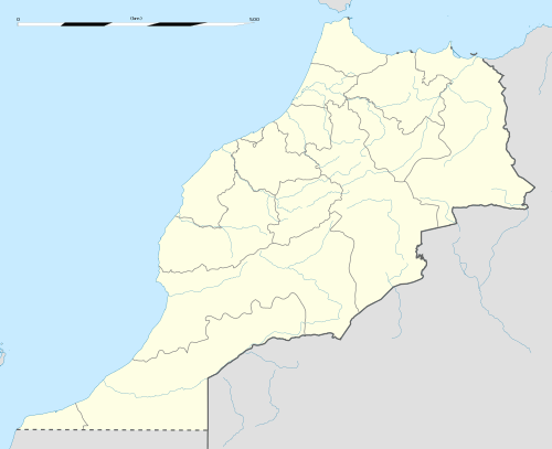 Chefchaouen location of Chefchaouen in Morocco | |
| Coordinates: 35°10′17″N 5°16′11″W / 35.17139°N 5.26972°W | |
| Country | Morocco |
| Province | Chefchaouen |
| Founded | 1471 |
| Government | |
| • Governor | Mhamed Haddan |
| • Mayor | Mohamed Said al-Alami |
| Elevation | 564 m (1,850 ft) |
| Population (2014) | |
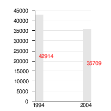
| • Total | 42,786 |
| Time zone | (GMT) Casablanca, Monrovia |
Chefchaouen or Chaouen (Arabic: شفشاون/الشاون, Shafshāwan (pronounced IPA: ʃəfˈʃɑˑwən);Berber: ⴰⵛⵛⴰⵡⵏ, Ashawen; Portuguese: Xexuão; Spanish: Xauen, lit. "horns") is a city in northwest Morocco. It is the chief town of the province of the same name, and is noted for its buildings in shades of blue.
Chefchaouen is situated in the Rif Mountains, just inland from Tangier and Tetouan. The city was founded in 1471,[1] as a small fortress which still exists to this day, by Moulay Ali Ben Moussa Ben Rached El Alami (a descendant of Ibn Machich and Idris I, and through them, of the Islamic prophet Muhammad) to fight the Portuguese invasions of northern Morocco.[2] Along with the Ghomara tribes of the region, many Moriscos and Jews settled here after the Spanish Reconquista in medieval times.[3] In 1920, the Spanish seized Chefchaouen to form part of Spanish Morocco. Spanish troops imprisoned Abd el-Krim in the kasbah from 1916 to 1917, after he talked with the German consul Dr. Walter Zechlin (1879–1962). (After defeating him with the help of the French, Abd el-Krim was deported to Réunion in 1926.) Spain returned the city after the independence of Morocco in 1956.
Background
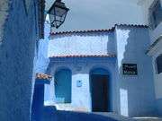
Chefchaouen or Chaouen, as it is often called by Moroccans, is a popular tourist destination because of its proximity to Tangier and the Spanish enclave of Ceuta. The name refers to the shape of the mountain tops above the town, that look like the two horns (chaoua) of a goat. "Chef Chaouen" derives from the Berber word for horns, Ichawen. There are approximately two hundred hotels catering to the summer influx of European tourists. One distinction possessed by Chefchaouen is its blue-rinsed houses and buildings.
Chefchaouen is a popular shopping destination as well, as it offers many native handicrafts that are not available elsewhere in Morocco, such as wool garments and woven blankets. The goat cheese native to the area is also popular with tourists.
The countryside around it has a reputation for being a prolific source of kief. The Chefchaouen region is one of the main producers of cannabis in Morocco. Hashish is subsequently sold all over town, but is mostly the domain of native Chaouenis. A nearby attraction is the Kef Toghobeit Cave which is one of the deepest caves in Africa.[4]
Chefchaouen's blue walls are a popular subject of interest. There are several theories as to why the walls were painted blue. One popular theory is that the blue keeps mosquitos away, another is that Jews introduced the blue when they took refuge from Hitler in the 1930s. The blue is said to symbolize the sky and heaven, and serve as a reminder to lead a spiritual life.[5]
The growing tourist industry is geared especially towards Spanish tourists, who are especially numerous during great Catholic feasts like Semana Santa and Christmas.
Places of worship
There are a number of distinct mosques in the town. Aside from the mosque at Place Uta Hammam in the medina, there is also a mosque dedicated to the patron saint of Northern Morocco's Jebalah region, Moulay Abdeslam Ben Mchich Alami. His tomb and the village surrounding it is by the way an hour's drive or so from Chefchaouen on the old road to Larache. There is also a ruined mosque built by the Spanish, with stairs still in the tower.
Tourism
The beauty of Chefchaouen's mountainous surroundings are enhanced by the contrast of the brightly painted medina (old town). It is this beauty and the relaxed atmosphere of the town that makes Chefchaouen very attractive to visitors.
The main square in the medina is lined with cafes and filled to the brim with locals and tourist mingling easily. Another reason why backpackers love Chefchaouen is the easy availability of drugs. Tourism in Chaouen is driven by its reputation as center of the marijuana plantations region in North Morocco. During the summer approximately two hundred hotels cater to the influx of European tourists.[6]
Demography
Sister cities
-
 Issaquah, Washington, United States [8] (Since April 11, 2007)
 -
 Vejer de la Frontera, Spain [9]
 - Ronda, Spain [10]
-
 Kunming, China
 -
 Testour, Tunisia
Gallery
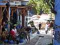 Shops in Chefchaouen
.jpg) Chefchaouen - in blue
Chefchaouen - in blue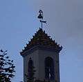 The Iglesia (Spanish for church). Currently a theatre
 Shrine in Chefchaouen
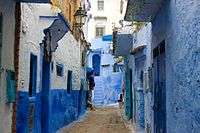 Alley in Chefchaouen
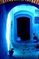 The beauty of simplicity of the doors
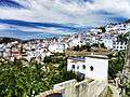 Chefchaouen from above
.jpg) womens from Chefchaouen
womens from Chefchaouen
External links
| Wikimedia Commons has media related to Chefchaouen. |
| Wikivoyage has a travel guide for Chefchaouen. |
- Chaouen Info - Information about the city and province of Chefchaouen or Xauen
- Lexicorient
- Town Chefchaouen in the north of Morocco
- Photos of Chefchaouen's blue architecture
- The blue city - Chefchaouen
References and notes
- ↑ https://books.google.com/books?id=jdlKbZ46YYkC&pg=PA208#v=onepage&q=morocco&f=false| A history of the Maghreb in the Islamic period
- ↑ Fiche technique de la Grande Mosquée de Chefchaouen Archived September 28, 2007, at the Wayback Machine. (French), شفشاون (Arabic)
- ↑ España y Marruecos, ejemplos de Interculturalidad a través de la lengua - by Francisco Moscoso García
- ↑ McWhirter, ed.: Norris (1977). Guinness book of records. (24th ed.). Enfield, Middlesex: Guinness Superlatioes Ltd. p. 62. ISBN 090042480X.
- ↑ "Chefchaouen: Walking the blue streets of Morocco". Middle East Eye. Retrieved 2016-04-10.
- ↑ "The Blue City: Chefchaouen - Morocco". I Love Traveling. Retrieved 2016-11-08.
- ↑ The equivalent Spanish Wikipedia (42.914 inhabitants at the 1994 census)
The equivalent French Wikipedia found here - ↑ A resolution of the city council of Issaquah, Washington, establishing Chefchaouen, Morocco as Issaquah's newest sister city.
- ↑ Chaouen está hermanada con Vejer de la Frontera (Cádiz), que a su vez estuvo bajo el dominio musulmán durante cinco siglos.
- ↑ viendo Chaouen desde lejos podríamos pensar que se trata de uno de los pueblos blancos de la Serranía de Ronda. De hecho esta ciudad está hermanada con Ronda.
Capital: Tangier | ||
| Prefectures and provinces | 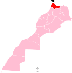 | |
| Cities | ||
Capital: Chefchaouen | ||
| Municipalities | ||
| Rural communes | ||
Coordinates: 35°10′17″N 5°16′11″W / 35.17139°N 5.26972°W