Chastel Rouge
| Arabic: قلعة يحمور | |
 Chastel Rouge | |
 Shown within Syria | |
| Location | Syria |
|---|---|
| Region | Tartus Governorate |
| Coordinates | 34°48′44″N 35°58′14″E / 34.812222°N 35.970556°E |
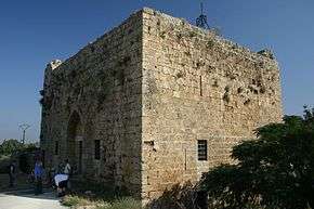
Chastel Rouge, also called Qal’at Yahmur قلعة يحمور (Castle of Yahmur) is a small Crusader stronghold in the North West of Syria that belonged to the County of Tripoli. It is also identified as Castrum Rubrum mentioned in Latin texts. The castle stands in the village of Yahmur, at 12 kilometres distance from Tartus and 10 kilometres from Safita, where the Tortosa and Chastel Blanc Crusader castles can be found.
History
Little is known about the capture and early development of the place by the Crusaders. This is because it was a castle of secondary importance, and also to some doubts in identifying the castle in medieval sources. The stronghold seems to be in the hands of a Frankish family, the Montolieu, vassals of the Counts of Tripoli. Thus, it was part of the network of castles defending the County, for example Crac des Chevaliers, Chastel Blanc and Arima.
The Counts of Tripoli transferred the stronghold to the Hospitallers, and the Montolieus were given 400 bezants as compensation. In 1188, Saladin attacked the stronghold and destroyed it. The Crusaders could most probably retrieve it and keep it until they lost the County one century later.
Description of the place
The village of Yahmur is located in the coastal plain between Tartus and Tripoli. Consequently, Chastel Rouge did not possess natural defences, as many other castles did.
The stronghold consists in a two-floor donjon, 16 metres long and 14 metres wide, enclosed in rectangular outer walls of 42 metres length and 37 width, with towers on the north-western and south-eastern angles. The first floor was divided in two storeys by a wooden floor that does not exist any more. Upper floors can be reached through stairs running along the walls inside and outside the donjon.
The construction cannot be dated with exactitude, however two main phases can be recognised: the first phase dates from the beginning of the 12th century and includes the outer walls, while the donjon was built at the beginning of the 13th century .
References
- Jean Mesqui, Châteaux d’Orient, Liban, Syrie, Ed. Hazan, 2001, p. 67-68
- Hugh Kennedy, Crusader Castles, Cambridge University Press, 1994, p. 72-75
External links
| Wikimedia Commons has media related to Yahmour. |
Coordinates: 34°48′44″N 35°58′14″E / 34.81222°N 35.97056°E
Roman Catholic chivalric order and sovereign subject of international law, founded in 1099 in Jerusalem, | |||||||||||||||||||||||||||||||||||||||||||||||
| Organisation | .svg.png) | ||||||||||||||||||||||||||||||||||||||||||||||
| Auxiliaries |
| ||||||||||||||||||||||||||||||||||||||||||||||
| Culture | |||||||||||||||||||||||||||||||||||||||||||||||
| Society | |||||||||||||||||||||||||||||||||||||||||||||||
| History, including major territories, premises, and battles of the Knights Hospitaller |
| ||||||||||||||||||||||||||||||||||||||||||||||
| |||||||||||||||||||||||||||||||||||||||||||||||