Bhilai Charoda
| Bhilai Bhilai Power House | |
|---|---|
| city | |
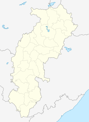 Bhilai  Bhilai Location in Chhattisgarh, India | |
| Coordinates: 21°13′11″N 81°27′27″E / 21.21979°N 81.45751°ECoordinates: 21°13′11″N 81°27′27″E / 21.21979°N 81.45751°E | |
| Country |
|
| State | Chhattisgarh |
| District | Durg |
| Population (2001) | |
| • Total | 87,170 |
| Languages | |
| • Official | Hindi, Chhattisgarhi |
| Time zone | IST (UTC+5:30) |
| PIN | 490025 |
| Telephone code | BSNL: 07826, Others: 0788 |
| Vehicle registration | CG 07 |
Charoda is a town and a municipality in Durg district in the state of Chhattisgarh, India.
Demographics
As of 2001 India census,[1] Charoda had a population of 87,170. Males constitute 52% of the population and females 48%. Charoda has an average literacy rate of 72%, higher than the national average of 59.5%; with male literacy of 80% and female literacy of 64%. 13% of the population is under 6 years of age.
Charoda is situated equidistant, 20 kilometres, from Durg and Raipur (the state capital). Charoda comprises three sub-towns. Bhilai Marshalling Yard (BMY), Charoda Basti and Deobaloda. BMY is a railway yard/colony famous for being the biggest traction shed once upon a time. Basti is a place where most of the retired people from BMY settle down. Deobaloda, historically, is the oldest all three sub-towns.
Places of interest
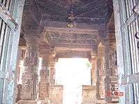
Deobaloda has a very ancient temple of Lord Shiva, from the 5th century. This is a very beautiful temple, and has a pond near it, with a myth that this pond has an underground link to another old town in Chhattisgarh state named Arang.
Besides Deobaloda, Charoda has some temples like Sri Hanuman Mandir, Sri Kali badi, Sri Ram Mandir, Sri Jaganath Mandir, a Church - St. Vincent Palloti Church, a Mosque besides other places of worship.
The oldest English Medium School here is Jyoti Vidyalaya which was started by the FIH sisters in 1969. The next school started by them was Jyoti Hr. Sec. Eng. Med. School., Nutkhat, The International Pre-School is one of the latest addition in the education fraternity of Charoda
Transport
Deobaloda is separated from BMY by main railway line (Mumbai - Howrah). BMY and Basti is separated by GE Road (National Highway 6). This highway is four lane between bhilai and raipur. Means of transport constitute city buses(public buses), buses(private buses), tempos, autos. In rail route main station is Devbaloda charoda along with various railway cabin halts.
References
- ↑ "Census of India 2001: Data from the 2001 Census, including cities, villages and towns (Provisional)". Census Commission of India. Archived from the original on 2004-06-16. Retrieved 2008-11-01.