Charnwood Forest

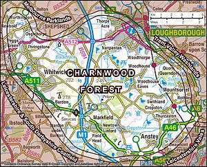
Charnwood Forest is an upland tract in north-western Leicestershire, England, bounded by Leicester, Loughborough and Coalville. The area is undulating, rocky and picturesque, with barren areas. It also has some extensive tracts of woodland; its elevation is generally 600 ft (180 m) and upwards, the area exceeding this height being about 6,100 acres (25 km2). The highest point, Bardon Hill, is 912 ft (278 m). On its western flank lies an abandoned coalfield, with Coalville and other former mining villages, now being regenerated and replanted as part of the National Forest. The M1 motorway, between junctions 22 and 23, cuts through Charnwood Forest.
The hard stone of Charnwood Forest has been quarried for centuries,[1] and was a source of whetstones and quern-stones. The granite quarries at Bardon Hill, Buddon Hill and Whitwick are of national importance and supply crushed aggregate, much by train, to a wide area of southern Britain.
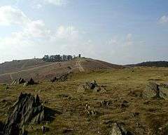
The forest is an important recreational area with woodland walks, noted for their displays of bluebells in the early spring, rock climbing and hillwalking. Popular places with public access include Bardon Hill, Beacon Hill, Bradgate Park, Swithland Wood and the Outwoods and Stoneywell Cottage (National Trust ).
Extent
The area of hills and open land known as Charnwood Forest has no jurisdictional boundary. (The Borough of Charnwood covers roughly two thirds of Charnwood Forest, and the eastern half of the borough is not part of the forest). Furthermore, despite its name, Charnwood was never a royal forest, and was never subject to forest law.[2] So although it is an ancient and well established locality,[3] it has only recently been officially defined, by the Natural England national character area (NCA) process,[4][5] which takes a somewhat wider definition than many previous attempts to define the area.[6][7]
Geology
Many of the craggy rocks of Charnwood Forest are of volcanic origin and are very old, dating back through 600 million years to Precambrian times.[8] It was the site of the first ever recorded discovery of Charnia masoni, the earliest known large, complex fossilised species on record. It was discovered in 1957 by a local schoolboy named Roger Mason (thus masoni) who, with friends, was exploring a quarry near the Charnwood village of Woodhouse Eaves. The rocks of Charnwood Forest remain the only place in Western Europe where these Precambrian fossils have been found.[9] Along the western edge of Charnwood Forest the rocks are mainly Precambrian igneous Diorites. These formed from molten lava deep within the sedimentary rocks, cooling slowly to produce hard, blocky rock with large crystals. This is extensively quarried for roadstone around Groby, Markfield and Whitwick, and is known as granite (formerly also called Markfieldite).[10] The central area of the forest has older rocks still. These are sedimentary and are very variable in character, They were formed by material from volcanoes, settling in deep water, and it is in these beds that the fossils are found. Uplifting, tilting and erosion have produced the distinctive jagged outcrops found across the highest parts of Charnwood.[11] On the eastern side, a much more recent series of rocks are found. Again igneous Diorites, that formed deep underground, but these are Ordovician, from a mere 450 million years ago.[12] These are extensively quarried in the areas near Mountsorrel.
History
The earliest form of the name Charnwood is probably derived from cerne woda, from the Celtic carn, meaning cairn, and the Old English wudu, meaning wood. Some sources give cwern as the derivation, meaning a tool used to grind grain and other materials by hand. The area was a source of stone for these tools, called quern-stones.[13]
Archeological evidence has shown that the area was inhabited as far back as the Neolithic period, approximately 4,000–2,000 BC. Beacon Hill is the site of a Bronze Age hill fort, dating from between 600 BC – 43 AD. This forms one of the last surviving visible features in the landscape known to the Coritani, the tribe who occupied most of the East Midlands area at the time of the Roman Conquest.
According to Domesday Book, there was only one settlement in Charnwood Forest in 1086, at Charley whose name would appear to come from the same root, with the suffix -ley denoting open land, rather than forest.
In the 200 years after the Norman conquest, newly created settlements took major areas of land out of the forest for use in agriculture. Quorn was established between 1086 and 1153, and all the land up to Woodhouse had been reclaimed from the forest by 1228.
There were comparatively few major changes in land use in the post Medieval period, until the demand for timber and charcoal for the early Industrial Revolution contributed to a further loss of woodland. By the end of the 18th century, most of the woodland had disappeared leaving large areas of moorland and pasture.
In literature
The area was the inspiration for "Charnwood Poems", a collection of poems by the author, playwright and poet Albert Francis Cross (1863–1940). It is also the setting for the speculative fiction novel "Some Kind of Fairy Tale" by Graham Joyce (2012), in which it is depicted as a possible portal to the realm of fairies.
Wildlife and geological sites

Charnwood Forest covers approx 67 sq mi (170 km2) of Leicestershire, split over three local government districts: Charnwood Borough, North West Leicestershire District and Hinckley and Bosworth District. It includes a national nature reserve (NNR), 19 SSSIs (Some subdivided in the list of sites below), 4 GCR sites of international geological importance plus a further 6 GCR sites, 13 Regionally Important Geological Sites (RIGS), five local nature reserves (LNRs), seven Leicestershire and Rutland Wildlife Trust (LRWT) nature reserves, and 1 Woodland Trust woodland. 17 sites have open access to the public. Footpaths and bridleways give views and limited access to the other sites listed, and to the rest of the Charnwood Forest landscape. Over half of Charnwood Forest is included within the English National Forest. It is also crossed by two waymarked long distance walking routes – the Leicestershire Round and the Ivanhoe Way.[14] The 45 sites listed here include sites with statutory wildlife or geological designations, plus other sites included in published lists of notable sites. On both the map and table, green denotes a site open to the public, amber denotes a site with limited access or restricted by permit or membership. Red denotes a site with no public access except by special arrangement with the owners.
| Map No. | Site Name | Status | Access | Location and map link | Area (ha) | Habitat | Ownership and details |
|---|---|---|---|---|---|---|---|
| 1 | Breedon Cloud Wood and Quarry | SSSI(B&G)[15] & RIGS[16] | Restricted | 52°47′19″N 1°23′10″W / 52.7886°N 1.3860°W SK415214 | 63 | Ancient woodland and limestone quarry | Breedon Cloud Wood is owned by LRWT. Permit needed.[17] Cloud Hill Quarry is owned by Ennstone Breedon Ltd. |
| 2 | Shepshed Cutting | SSSI(G)[15] | Partial | 52°45′47″N 1°19′00″W / 52.7630°N 1.3168°W SK462186 | 6.1 | Old Quarry with Galena of a type unknown elsewhere in the world.[18] | The quarry is crossed by a disused railway cutting of the Charnwood Forest Railway which is now a path and cycleway and of the short-lived Charnwood Forest Canal.[19] |
| 3 | Morley Quarry, Shepshed | LNR,[20] GCR[21] & RIGS[22] | Open | 52°45′24″N 1°17′46″W / 52.7566°N 1.2961°W SK476179 | 3 | Disused quarry | Charnwood Borough Council. Car Park off Iveshead Road.[22] Cliff faces show the oldest of Charnwood's Precambrian rocks and the Triassic unconformity.[23] |
| 4 | Newhurst Quarry, Shepshed | SSSI(G),[15] GCR[24] & RIGS[16] | None | 52°45′23″N 1°16′58″W / 52.7565°N 1.2828°W SK485179 | 9 | Quarry currently being used for waste disposal | Landfill site managed by Biffa.[25] GCR listing for Mineralogy significance.[24] |
| 5 | Holywell Wood | Woodland[26] | Private | 52°45′36″N 1°15′00″W / 52.7599°N 1.2501°W SK507183 | Woodland | Private. Public footpath runs along its northern edge from Snells Nook Lane. | |
| 6 | Longcliffe Quarry, Shepshed | RIGS[16] | None | 52°47′04″N 1°16′21″W / 52.7844°N 1.2726°W SK492170 | Quarry site | Midland Quarry Products: working quarry. | |
| 7 | Ives Head | GCR(I)[21] & RIGS [27] | Partial | 52°44′55″N 1°17′36″W / 52.7485°N 1.2933°W SK478170 | Old quarry and craggy hilltop | Privately owned disused quarry. A public bridleway passes 500m south of the summit (201m). | |
| 8 | Blackbrook Reservoir | SSSI(B&G)[15] & GCR[21] | Partial | 52°45′12″N 1°19′27″W / 52.7532°N 1.3243°W SK457175 | 38.6 | Open water, wooded banks, wetlands | Severn Trent Water. Access to the viaduct and wooded slopes via One Barrow Lane.[28] |
| 9 | Grace Dieu And High Sharpley | SSSI (B&G)[15] | Partial | 52°44′56″N 1°21′14″W / 52.7489°N 1.3540°W SK437170 | 89 | Heathland and Carbonifierous limestone outcrops | Private owners. Adjoins National Forest access land and Grace Dieu Priory site. |
| 10 | Cademan Wood | Woodland[26] | Partial | 52°44′56″N 1°21′09″W / 52.7489°N 1.3526°W SK438170 | Mixed woodland with rocky outcrops | De Lisle family. Public footpaths and informal open access.[29] Spectacular outcrops that formed very close to a Precambrian volcano.[23] | |
| 11 | Snibston Country Park and Grange Nature Reserve | LNR[20] | Open | 52°43′26″N 1°23′08″W / 52.7238°N 1.3855°W SK416142 | 40 | Woodland, meadow, marsh and ponds | Leicestershire County Council.[30] |
| 12 | Nature Alive! Coalville | LNR[20] | Open | 52°43′55″N 1°22′41″W / 52.7319°N 1.3780°W SK421151 | 6 | Regenerated scrub and wetland on former industrial land | North West Leicestershire District Council. Valuable site for dragonflies.[31] |
| 13 | Whitwick Quarry | RIGS[16] | None | 52°44′20″N 1°20′16″W / 52.7389°N 1.3379°W SK448159 | Quarry site | Midland Quarry Products | |
| 14 | Mount St Bernard Abbey | Abbey[26] | Partial | 52°44′29″N 1°19′28″W / 52.7415°N 1.3245°W SK457162 | Cistercian Abbey | Visitors to the Abbey and grounds are made welcome.[32] The crags around The Knoll show steeply dipping Charnian tuffs.[33] | |
| 15 | Charnwood Lodge | NNR, SSSI(B&G)[15] & GCR[21] | Restricted | 52°44′06″N 1°18′41″W / 52.7351°N 1.3113°W SK466155 | 193.5 | Acid and heath grasslands with some mixed woodland | LRWT, permit needed for parts.[34] Timberwood Hill and Warren Hills are accessible under the right to roam.[35] |
| 16 | Jubilee Wood, Woodhouse Lane | Public woodland | Open | 52°44′37″N 1°14′46″W / 52.7437°N 1.2460°W SK510165 | 10 | Mixed woodland and rocky outcrops | Leicestershire County Council.[36] |
| 17 | Loughborough Outwoods, Woodhouse Lane | SSSI(B&G)[15] GCR (I)[21] | Open | 52°44′21″N 1°14′19″W / 52.7392°N 1.2387°W SK515160 | 44.6 | Mixed woodland and rocky outcrops | Charnwood Borough Council. Free car park.[37] |
| 18 | Woodbrook and Deans Wood | Stream and woodland[26] | Partial | 52°44′15″N 1°15′13″W / 52.7375°N 1.2535°W SK505158 | Charnwood stream and woodland | Permissive path from Jubilee wood to Deans Lane.[38] | |
| 19 | Charley Woods | Nature reserve | Open | 52°43′44″N 1°17′48″W / 52.7288°N 1.2966°W SK476148 | 28.8 | Oak woodland | LRWT, open to the public.[39] |
| 20 | Bardon Hill Quarry | SSSI(G)[15] GCR[21] and RIGS[16] | None | 52°42′55″N 1°19′19″W / 52.7154°N 1.3220°W SK459133 | 79 | Quarry. Precambrian Igneous Rocks | Aggregate Industries. |
| 21 | Bardon Hill | SSSI(B)[15] | Partial | 52°42′52″N 1°19′08″W / 52.7145°N 1.3190°W SK461132 | 13 | High moorland, highest point in Leicestershire (278m) | Private land. Access to the summit, via public footpaths with expansive views.[40] |
| 22 | Beacon Hill, Woodhouse Eaves | SSSI(B&G)[15] GCR[21] & Ancient Monument | Open | 52°43′36″N 1°14′30″W / 52.7266°N 1.2418°W SK513146 | 135 | Heathland, rocks, woodland hillfort | Leicestershire County Council.[41] |
| 23 | Broombriggs Farm and Windmill Hill | Farm Trail | Open | 52°43′29″N 1°13′38″W / 52.7247°N 1.2271°W)] SK523144 | 55 | Farmland and heath | Leicestershire County Council. Pay car park.[42] |
| 24 | Buddon Brook | Stream[26] | Partial | 52°44′07″N 1°10′41″W / 52.7352°N 1.1780°W SK556156 | Stream habitat | Private farmland. A public footpath runs beside the stream. | |
| 25 | Buddon Wood | SSSI(B&G)[15] and RIGS[16] | None | 52°43′54″N 1°10′30″W / 52.7316°N 1.1751°W SK558152 | 89 | Ancient Oak woodland, now mostly quarried away, | Private – including Lafarge Aggregates.[43] |
| 26 | Main Quarry, Mountsorrel | SSSI(G)[15] & GCR[44] | None | 52°43′40″N 1°08′49″W / 52.7278°N 1.1470°W SK577148 | 14 | Quarry site | Lafarge Aggregates. Largest manmade hole in Europe.School visits are possible.[45] |
| 27 | Swithland Reservoir and Brazil Island | SSSI (B&G)[15] and RIGS | Partial | 52°43′21″N 1°10′20″W / 52.72260°N 1.1723°W SK560142 | 98 | Open water, wooded banks | Severn Trent Water. Limited road and footpath access. Excellent views from Great Central Railway, which crosses the reservoir via Brazil Island. |
| 28 | The Brand, Swithland | SSSI(B&G)[15] & GCR[21] | None | 52°42′53″N 1°12′29″W / 52.7147°N 1.2080°W SK536133 | 18 | Oak woodland, grassy heath and old slate quarries | Private (Martin family). Occasional open days.[27] |
| 29 | Roecliffe Manor Lawns | SSSI(B)[15] | None | 52°42′27″N 1°12′56″W / 52.7076°N 1.2155°W SK531125 | 1.2 | Species rich grassland with rare fungi | Private (Cottingham family). |
| 30 | Swithland Wood | SSSI(B&G)[15] | Open | 52°42′21″N 1°12′08″W / 52.7057°N 1.2022°W SK540123 | 61 | Ancient Woodland and disused slate quarries | Bradgate Park Trust. Pay car parks. |
| 31 | Benscliffe Wood | SSSI(B)[15] | None | 52°42′34″N 1°14′26″W / 52.7095°N 1.2406°W SK514127 | 10 | Mixed woodland | Private wood. Particularly rich in lichen species. |
| 32 | Ulverscroft Nature Reserve, Whitcroft's Lane | Nature reserve | Restricted | 52°42′26″N 1°16′34″W / 52.7071°N 1.2762°W SK490124 | 56 | Mixed woodland, marshy grassland and meadow | NT, managed by LRWT (NT members need LRWT permit).[46] |
| 33 | Rocky Plantation, Nr Markfield | Nature reserve | Restricted | 52°42′06″N 1°16′19″W / 52.7016°N 1.2719°W SK493118 | 3.4 | Mixed woodland and rocky outcrops | NT, managed by LRWT. Open to Wildlife Trust and National Trust members only.[47] |
| 34 | Lea Meadows, Ulverscroft Lane | SSSI[15] | Open | 52°41′56″N 1°15′10″W / 52.6988°N 1.2527°W SK506115 | 12 | Meadow | LRWT, open to the public.[48] |
| 35 | Billa Barra Hill | LNR[20] & RIGS[16] | Open | 52°41′51″N 1°18′32″W / 52.6974°N 1.3089°W SK468113 | 20 | Old quarry, grassland, mature and recent woodland. | Hinckley and Bosworth Borough Council. Open to the public. Car Park on Billa Barra Lane.[49] |
| 36 | New Cliffe Hill Quarry | RIGS[16] | None | 52°41′34″N 1°18′59″W / 52.6929°N 1.3164°W SK463108 | 243 | Quarry. Precambrian Rocks | Midland Quarry Products: working quarry (A tunnel links this to Cliffe Hill Quarry).[50] |
| 37 | Cliffe Hill Quarry | SSSI(G)[15] GCR (I)[21] and RIGS[16] | None | 52°41′24″N 1°17′55″W / 52.6901°N 1.2987°W SK475105 | 37 | Quarry. Precambrian Rocks | Midland Quarry Products: working quarry.[51] |
| 38 | Altar Stones, Markfield | Nature reserve | Open | 52°41′30″N 1°17′02″W / 52.6918°N 1.2839°W SK485107 | 3.7 | Rough heath grassland with rock outcrops | LRWT, open to the public.[52] |
| 39 | Hill Hole Quarry, Markfield | Nature reserve and RIGS[16] | Open | 52°41′14″N 1°16′57″W / 52.6873°N 1.2825°W SK486102 | 5.4 | Flooded quarry, rock faces and grassland | Hinckley and Bosworth Borough Council. Open to the public.[53] The old quarry faces show the youngest of the area's Precambrian rocks. [54] |
| 40 | Cropston Reservoir | SSSI(B&G)[15] | None | 52°41′38″N 1°11′37″W / 52.6939°N 1.1936°W SK546110 | 55 | Open water, wetlands | Severn Trent Water. No access but with good views from Bradgate Park. |
| 41 | Bradgate Park | SSSI(B&G)[15] GCR(I)[21] | Open | 52°41′30″N 1°13′17″W / 52.6917°N 1.2214°W SK530110 | 340 | Bracken heath, rocks, river, woodland, ancient oaks | Bradgate Park Trust. Pay car parks. |
| 42 | Sheet Hedges Wood, Newtown Linford | SSSI(B)[15] | Open | 52°40′25″N 1°13′35″W / 52.6735°N 1.2265°W SK524087 | 30 | Mixed woodland | Leicestershire County Council. Free car park near Groby Pool.[55] |
| 43 | Groby Pool | SSSI(B)[15] | Partial | 52°40′08″N 1°13′41″W / 52.6690°N 1.2280°W SK523082 | 28 | Open water, wetlands | Amalgamated Roadstone Corp. One side has good roadside paths and access with a large nearby free car park. |
| 44 | Groby Quarry | RIGS[16] | None | 52°40′12″N 1°13′30″W / 52.6699°N 1.2251°W SK525083 | Working Quarry | Amalgamated Roadstone Corporation (ARC) | |
| 45 | Martinshaw Wood | Public woodland[26] | Open | 52°39′36″N 1°14′51″W / 52.6601°N 1.2474°W SK510072 | 102 | Mixed woodland | Woodland Trust.[56] |
Abbreviations used in the table: National nature reserve (NNR). Site of Special Scientific Interest (SSSI) (B=Biological, G=Geological). Geological Conservation Review (GCR)(I=of International importance).[57] Regionally Important Geological Site (RIGS). Leicestershire and Rutland Wildlife Trust (LRWT). National Trust (NT). Local nature reserve (LNR).
See also
Notes
![]() This article incorporates text from a publication now in the public domain: Chisholm, Hugh, ed. (1911). "Charnwood Forest". Encyclopædia Britannica. 5 (11th ed.). Cambridge University Press.
This article incorporates text from a publication now in the public domain: Chisholm, Hugh, ed. (1911). "Charnwood Forest". Encyclopædia Britannica. 5 (11th ed.). Cambridge University Press.
- ↑ Ambrose 2007, p. 42.
- ↑ Squires 1986, p. 10.
- ↑ Squires 1986, p. 11.
- ↑ Hirst 1997.
- ↑ "Natural England Access to Evidence - National Character Areas" (PDF). Naturalengland.org.uk. Retrieved 2016-08-29.
- ↑ Crocker 1981, p. 13.
- ↑ Webster 1997, p. 42.
- ↑ Ambrose 2007, p. 2.
- ↑ Carney 2010.
- ↑ Ambrose 2007, p. 27.
- ↑ Ambrose 2007, p. 14.
- ↑ Ambrose 2007, p. 6.
- ↑ "Charnwood History Overview". People Making Places 2000: A creative Map of Charnwood. Retrieved 2010-08-07.
- ↑ "Archived copy". Archived from the original on 28 September 2011. Retrieved 2011-03-01.
- 1 2 3 4 5 6 7 8 9 10 11 12 13 14 15 16 17 18 19 20 21 22 23 "Designated Sites View". English-nature.org.uk. Retrieved 2016-08-29.
- 1 2 3 4 5 6 7 8 9 10 11 "Archived copy". Archived from the original on 20 August 2011. Retrieved 2011-03-01.
- ↑ "Cloud Wood - Leicestershire & Rutland Wildlife Trust". Lrwt.org.uk. Retrieved 2016-08-29.
- ↑ "County: Leicestershire, Site name: Shepshed Cutting, District: Charnwood" (PDF). English-nature.org.uk. Retrieved 2016-08-29.
- ↑ Ambrose 2007, p. 36.
- 1 2 3 4 "Natural England - Special Sites". English-nature.org.uk. 2013-10-20. Retrieved 2016-08-29.
- 1 2 3 4 5 6 7 8 9 10 Carney 2000, p. 16.
- 1 2 "Morley Quarry LNR" (PDF). Nationalforest.org. Retrieved 2016-08-29.
- 1 2 Ambrose 2007, p. 18.
- 1 2 Bevins 2010, p. 8.
- ↑ "Archived copy". Archived from the original on 2 March 2011. Retrieved 2011-03-01.
- 1 2 3 4 5 6 Webster 1997, p. 41.
- 1 2 Crocker, J and Daws, J, 1996 Spiders of Leicestershire, p.207
- ↑ Ambrose 2007, p. 33.
- ↑ "Grace Dieu and Cademan Woods". Leioc.org.uk. 2013-06-27. Retrieved 2016-08-29.
- ↑ "Archived copy". Archived from the original on 2 October 2010. Retrieved 2011-03-01.
- ↑ "Archived copy". Archived from the original on 6 July 2008. Retrieved 2011-03-01.
- ↑ "Home". Mount Saint Bernard. 2016-04-09. Retrieved 2016-08-29.
- ↑ Ambrose 2007, p. 34.
- ↑ "Charnwood Lodge - Leicestershire & Rutland Wildlife Trust". Lrwt.org.uk. Retrieved 2016-08-29.
- ↑ "Archived copy". Archived from the original on 3 October 2010. Retrieved 2011-03-01.
- ↑ "Archived copy". Archived from the original on 15 December 2010. Retrieved 2011-03-01.
- ↑ "The Outwoods - Parks and open spaces - Charnwood Borough Council". Charnwood.gov.uk. 2016-06-02. Retrieved 2016-08-29.
- ↑ "Archived copy". Archived from the original on 28 September 2011. Retrieved 2011-03-01.
- ↑ "Charley Woods - Leicestershire & Rutland Wildlife Trust". Lrwt.org.uk. Retrieved 2016-08-29.
- ↑ Ambrose 2007, p. 16.
- ↑ "Archived copy". Archived from the original on 6 June 2011. Retrieved 2011-03-01.
- ↑ "Archived copy". Archived from the original on 11 January 2011. Retrieved 2011-03-01.
- ↑ "Mountsorrel Granite Quarry information and photos". Aditnow.co.uk. 2007-11-02. Retrieved 2016-08-29.
- ↑ carney 2000, p. 16.
- ↑ "Bulk & Packed Cement | Lafarge Cement" (PDF). Lafarge.co.uk. Retrieved 2016-08-29.
- ↑ "Ulverscroft - Leicestershire & Rutland Wildlife Trust". Lrwt.org.uk. Retrieved 2016-08-29.
- ↑ "Rocky Plantation - Leicestershire & Rutland Wildlife Trust". Lrwt.org.uk. Retrieved 2016-08-29.
- ↑ "Lea Meadows - Leicestershire & Rutland Wildlife Trust". Lrwt.org.uk. Retrieved 2016-08-29.
- ↑ "About Billa Barra Hill | Billa Barra Hill | Hinckley & Bosworth Borough Council". Hinckley-bosworth.gov.uk. 2016-03-03. Retrieved 2016-08-29.
- ↑ "New Cliffe Hill Quarry, Stanton under Bardon, Leicestershire, England, UK". Mindat.org. Retrieved 2016-08-29.
- ↑ "Grace Dieu Wood | Visit National Forest". Nationalforest.org. Retrieved 2016-08-29.
- ↑ "Altar Stones - Leicestershire & Rutland Wildlife Trust". Lrwt.org.uk. Retrieved 2016-08-29.
- ↑ "About Hill Hole Quarry | Hill Hole Quarry | Hinckley & Bosworth Borough Council". Hinckley-bosworth.gov.uk. 2016-03-03. Retrieved 2016-08-29.
- ↑ Ambrose 2007, p. 35.
- ↑ "Archived copy". Archived from the original on 15 December 2010. Retrieved 2011-03-01.
- ↑ "Archived copy". Archived from the original on 29 March 2012. Retrieved 2011-03-01.
- ↑ Carney 2000, p. 17.
References
- Ambrose, Keith; Carney, John; Lott, Graham; Weightman, Gill; McGrath, Annette (2007). Exploring the landscape of Charnwood Forest and Mountsorrel: a walkers' guide to the rocks and landscape of Charnwood Forest and Mountsorrel. Keyworth, Nottingham: British Geological Survey. ISBN 978-0-85272-570-2.
- Carney, J. N.; Horak, J. M.; Pharaoh, T. C.; Gibbons, W.; Wilson, D.; Barclay, W. J.; Bevins, R. E.; Cope, J. C. W.; Ford, T. D. (2000). Precambrian Rocks of England and Wales (PDF). Geological Conservation Review Series, No.20. Peterborough: Joint Nature Conservation Committee.
- Carney, J. N. (2010). Guide to the Geology of Bradgate Park and Swithland Wood, Charnwood Forest (PDF). Occasional Report, OR/10/041. British Geological Survey. (This report includes two high quality geological maps)
- "Charnwood History Overview". People Making Places 2000: A creative Map of Charnwood. Retrieved 2010-08-07.
- Crocker, John, ed. (1981). Charnwood Forest: a Changing Landscape. Loughborough Naturalists' Club. ISBN 0-905837-10-X.
- Hirst, Alison (1997). Charnwood Forest: Natural area Profile (PDF).
- Squires, A. E.; Humphrey, W. (1986). The Medieval Parks of Charnwood Forest. Sycamore Press. ISBN 0-905837-15-0.
- Squires, A. E. (1981). "History of the Charnwood Forest Landscape". In John Crocker. Charnwood Forest: a Changing Landscape. Loughborough Naturalists' Club. ISBN 0-905837-10-X.
- Webster, Michael (1997). Birds of Charnwood. Kairos Press. ISBN 1-871344-12-3.
External links
Coordinates: 52°42′N 1°15′W / 52.70°N 1.25°W