Charmes-la-Côte
| Charmes-la-Côte | |
|---|---|
|
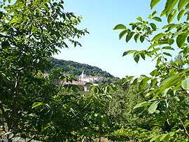
Le village de Charmes-la-Côte vu du Mulson | |
 Charmes-la-Côte | |
|
Location within Grand Est region  Charmes-la-Côte | |
| Coordinates: 48°37′35″N 5°49′42″E / 48.6264°N 5.8283°ECoordinates: 48°37′35″N 5°49′42″E / 48.6264°N 5.8283°E | |
| Country | France |
| Region | Grand Est |
| Department | Meurthe-et-Moselle |
| Arrondissement | Toul |
| Canton | Toul-Sud |
| Intercommunality | Communauté de communes du Toulois |
| Government | |
| • Mayor (2008–2014) | Jean-Luc Starosse |
| Area1 | 6.23 km2 (2.41 sq mi) |
| Population (1999)2 | 312 |
| • Density | 50/km2 (130/sq mi) |
| Time zone | CET (UTC+1) |
| • Summer (DST) | CEST (UTC+2) |
| INSEE/Postal code | 54120 / 54113 |
| Elevation |
224–409 m (735–1,342 ft) (avg. 360 m or 1,180 ft) |
|
1 French Land Register data, which excludes lakes, ponds, glaciers > 1 km² (0.386 sq mi or 247 acres) and river estuaries. 2 Population without double counting: residents of multiple communes (e.g., students and military personnel) only counted once. | |
Charmes-la-Côte is a commune in the Meurthe-et-Moselle department in north-eastern France.
See also
| Wikimedia Commons has media related to Charmes-la-Côte. |
This article is issued from Wikipedia - version of the 11/19/2014. The text is available under the Creative Commons Attribution/Share Alike but additional terms may apply for the media files.