Charles Pinckney National Historic Site
| Charles Pinckney National Historic Site | |
|---|---|
|
IUCN category V (protected landscape/seascape) | |
|
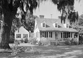
Snee Farm House | |
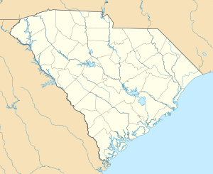 | |
| Location | Mount Pleasant, South Carolina, USA |
| Nearest city | Charleston, South Carolina |
| Coordinates | 32°50′46″N 79°49′29″W / 32.84611°N 79.82472°WCoordinates: 32°50′46″N 79°49′29″W / 32.84611°N 79.82472°W |
| Area | 28.45 acres (12 ha)[1] |
| Established | September 8, 1988 |
| Visitors | 45,254 (in 2011)[2] |
| Governing body | National Park Service |
| Website | |
|
Snee Farm-Charles Pinckney National Historic Site | |
| Nearest city | Mount Pleasant, South Carolina |
| Built | 1824 |
| NRHP Reference # | 73001702[3] |
| Significant dates | |
| Added to NRHP | April 13, 1973[3] |
| Designated NHL | November 7, 1973 |
The Charles Pinckney National Historic Site is a unit of the United States National Park Service, preserving a portion of Charles Pinckney's Snee Farm country retreat and plantation.[4][5][6][7] The site is located at 1254 Long Point Road, Mount Pleasant, South Carolina. Pinckney (1757-1824) was a member of a prominent political family in South Carolina. He fought in the American Revolutionary War and was one of the principal framers of the United States Constitution. He served as Governor of South Carolina, and as a member of the United States Senate and the House of Representatives. He was also President Thomas Jefferson's minister to Spain, after he helped Jefferson win the presidential campaign of 1800. The site was designated a National Historic Landmark in 1973, and was designated a National Historic Site in 1988.
Setting
The Charles Pinckney National Historic Site is located about 10 miles (16 km) northeast of Charleston, South Carolina, on 25 acres (10 ha) of Wando Neck, a peninsula formed by the Wando River and Cooper River. The site has wooded and swampy areas on the eastern and western parts of the property, and a manicured grassy area with ornamental plantings around the main house. The property includes, in addition to the main house, a barn, corncrib, and caretaker's residence. A stone cenotaph commemorates Colonel Charles Pinckney, Snee Farm's founder.[4]
History
Snee Farm was established by Colonel Charles Pinckney in 1754, and was inherited by his son also named Charles in 1782. The younger Pinckney used Snee Farm as a working plantation and country estate (it was conveniently accessible to Charleston by boat) until about 1816, when he placed the property in trust. The present main house was built in the 1820s, after it passed out of his hands. The estate remained largely intact until the 20th century, when development pressures prompted its subdivision. The site, covering the central portion of the historic estate, was purchased by preservationists in 1988, and was sold the same year to the National Park Service following the passage of enabling legislation by the United States Congress. Because the site no longer has any structures associated with the Pinckneys, details of their interaction with the property are limited to archaeological and documentary work.[4]
Photos
|


See also
- Gullah/Geechee Cultural Heritage Corridor
- List of National Historic Landmarks in South Carolina
- National Register of Historic Places listings in Charleston, South Carolina
References
- The National Parks: Index 2001-2003. Washington: U.S. Department of the Interior.
- ↑ "Listing of acreage as of December 31, 2011". Land Resource Division, National Park Service. Retrieved 2012-12-26.
- ↑ "NPS Annual Recreation Visits Report". National Park Service. Retrieved 2012-12-26.
- 1 2 National Park Service (2010-07-09). "National Register Information System". National Register of Historic Places. National Park Service.
- 1 2 3 "Cultural Resource History of Charles Pinckney National Historic Site" (PDF). National Park Service. Retrieved 2015-12-11.
- ↑ Snell, Charles W. (January 15, 1973). "Snee Farm (Charles Pinckney Farm)" (pdf). National Register of Historic Places - Nomination and Inventory. National Park Service. Retrieved 4 June 2012.
- ↑ "Snee Farm (Charles Pinckney Farm)" (pdf). Photographs. National Park Service. Retrieved 4 June 2012.
- ↑ "Snee Farm, Charleston County (Long Point Rd, off U.S. Hwy. 17, Mount Pleasant vicinity)". National Register Properties in South Carolina. South Carolina Department of Archives and History. Retrieved 4 June 2012.
External links
 Media related to Snee Farm-Charles Pinckney National Historic Site at Wikimedia Commons
- Official NPS website: Charles Pinckney National Historic Site
- Historic Charleston's Religious and Community Buildings, a National Park Service Discover Our Shared Heritage Travel Itinerary
- Historic American Buildings Survey (HABS) No. SC-87, "Snee Farm, 1240 Long Point Road, Mount Pleasant, Charleston County, SC", 48 photos, 21 measured drawings, 34 data pages, 4 photo caption pages
- Historic American Buildings Survey (HABS) No. SC-87-A, "Snee Farm, Servant's House, 1240 Long Point Road, Mount Pleasant, Charleston County, SC", 10 photos, 1 photo caption page
| Topics |   | |
|---|---|---|
| Lists by county |
| |
| Lists by city | ||
| Other lists | ||