Magnetawan
| Magnetawan | |
|---|---|
| Municipality (single-tier) | |
| Municipality of Magnetawan | |
 | |
 Magnetawan | |
| Coordinates: 45°40′N 79°38′W / 45.667°N 79.633°WCoordinates: 45°40′N 79°38′W / 45.667°N 79.633°W | |
| Country |
|
| Province |
|
| District | Parry Sound |
| Settled | 1870s |
| Incorporated | January 1, 1998 |
| Government | |
| • Type | Township |
| • Mayor | Sam Dunnett |
| • Federal riding | Parry Sound—Muskoka |
| • Prov. riding | Parry Sound—Muskoka |
| Area[1] | |
| • Land | 531.83 km2 (205.34 sq mi) |
| Population (2011)[1] | |
| • Total | 1,454 |
| • Density | 2.7/km2 (7/sq mi) |
| Time zone | EST (UTC-5) |
| • Summer (DST) | EDT (UTC-4) |
| Postal Code | P0A |
| Area code(s) | 705 |
| Website |
www |

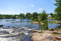
Magnetawan is a township in the Canadian province of Ontario, as well as the name of the primary population centre in the township. Located in the Almaguin Highlands region of the Parry Sound District, the township had a population of 1,454 in the 2011 Canadian census.
The core rock samples done by Walfried Schwerdtner in the surrounding area, show mostly foliated Grenville Gneiss.[2]
Barbara Hanley, the first woman ever elected mayor of a community in Canada, was born in Magnetawan in 1882.
The community of Magnetawan proper holds the status of designated place in Canadian censuses, separately from the rest of the township. Its population in the Canada 2011 Census was 264. It is twinned with the city of Baltimore, Maryland.
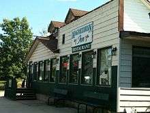
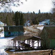
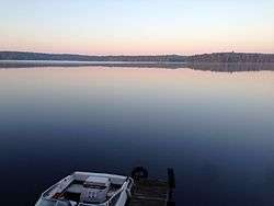
Magnetawan is a historic village with a surrounding municipality that provides various attractions. From the museum to the picturesque waters, are all a part of this municipality. The downtown used to consist of a restaurant named The Magnetawan Inn, also June's Inn, as well as a small hotel/bar, and a General Store. In the summer of 2011, on July 30, the General Store burned down taking part of the Magnetawan Inn with it.[3]
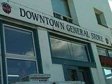
In the downtown, there is now a brand new general store/restaurant built between 2012 and 2013. Also, there is a museum, Lions Pavilion Park, farmers market, little shops, locks/dams, and a LCBO store. In the village, there is a school, churches, golf course named Ahmic Lake Golf Club, post office, a library, the municipality offices, and the municipality pavilion.[4] Magnetawan is also home to many resorts and rentable cottages. Two of the biggest resorts are Woodland Echoes as well as Ahmic Lake Resort, where the Swiss Country House Restaurant is located.
Communities
The township comprises the communities of Ahmic Harbour, Ahmic Lake, Cecebe, Cedar Croft, Chikopi, Dufferin Bridge, Magnetawan, North Seguin, Oranmore, Pearceley, Port Anson and Port Carmen, as well as the ghost town of Spence.
History
The first people to inhabit the region were the Hurons, Ojibway and Algonquins, who would visit the area in the summer for hunting and fishing but sheltered on Georgian Bay in the winter. While some Europeans explored the region in the early 19th century, settlement and colonization by Europeans was hardly taking place, so much so that the government considered turning the entire region into an Indian reserve.[5]
But when pine stands in southern Ontario became depleted, the area attracted loggers and the government changed its mind and encouraged settlement through free land grants, first offered in 1853. Settlement happened slowly but accelerated when the colonization road from Rosseau to Nipissing began being built in 1866.[5] In 1868, the government passed the Free Grand Land and Homestead Act and began advertising this extensively in European countries to attract new immigrants.[6] Croft Township was surveyed in 1869, Chapman Township in 1870, and the village of Magnetawan was mapped out in 1873.
The Township of Magnetawan was formed in 1998 through the amalgamation of the Township of Chapman and the Village of Magnetawan, along with the unincorporated geographic Townships of Croft and Spence.
Magnetawan in Native language means "swiftly flowing river."[7]
Demographics
| Canada census – Magnetawan community profile | |||
|---|---|---|---|
| 2011 | 2006 | 2001 | |
| Population: | 1454 (-9.7% from 2006) | 1610 (20.0% from 2001) | 1342 (1.4% from 1996) |
| Land area: | 531.83 km2 (205.34 sq mi) | 523.07 km2 (201.96 sq mi) | 523.07 km2 (201.96 sq mi) |
| Population density: | 2.7/km2 (7.0/sq mi) | 3.1/km2 (8.0/sq mi) | 2.6/km2 (6.7/sq mi) |
| Median age: | 54.3 (M: 54.6, F: 54.1) | 51.3 (M: 51.6, F: 50.9) | 48.5 (M: 49.2, F: 47.9) |
| Total private dwellings: | 1782 | 1901 | 1837 |
| Median household income: | $43,551 | $35,017 | |
| References: 2011[1] 2006[8] 2001[9] | |||
Population trend:[10]
- Population in 2011: 1454 (2006 to 2011 population change: -9.7%)
- Population in 2006: 1610
- Population in 2001: 1342
- Population total in 1996: 1324
- Magnetawan (village): 241
- Chapman (township): 645
- Population in 1991:
- Magnetawan (village): 267
- Chapman (township): 605
Mother tongue:[11]
- English as first language: 87.2%
- French as first language: 2.5%
- English and French as first language: 0%
- Other as first language: 10.3%
Local lakes and rivers
- Old Man's Lake
- Ahmic Lake Filled with these species of fish: Smallmouth Bass, Largemouth Bass, Pickerel(Walleye)stocked yearly,[12] Crappie, Sunfish, Rock Bass, Whitefish, Catfish, Perch, and Northern Pike.
- Lake Cecebe
- Magnetawan River
- Beaver Lake
Attractions
Though there are endless possibilities to do in Magnetawan, this is just a list of unique characteristics about this town.[13]
- Echo Rock on Lake Cecebe
- The shipwreck of the steamboat called the Wenoah in Lake Cecebe
- The Trans-Canada Trail
- Hand Operated Dam and Locks
- Knoepfli and Fagans Falls
- The Lighthouse on the Magnetawan River
- Woodland Echoes Resort http://www.woodlandechoes.on.ca/
- Camp Kahquah [14]
- Golfing
- Multipurpose Pavilion
- Horseback riding
- Fishing and boating in the local lakes
- Hunting
- Snowmobiling and dog sledding
See also
References
- 1 2 3 Statistics Canada 2011 Census - Magnetawan Census Profile
- ↑ Schwerdtner, W (2008). "Structure of Ahmic domain and its vicinity, southwestern Central Gneiss Belt, Grenville Province of Ontario (Canada)". Precambrian Research. 167 (1-2): 16–34. doi:10.1016/j.precamres.2008.07.002.
- ↑ [Nugget Staff. (2011, July 31). Magnetawan general store, restaurant destroyed by fire. Retrieved February 24, 2014, from Nugget.ca website:http://www.nugget.ca/2011/07/31/ magnetawan-general-store-restaurant-destroyed-by-fire].
- ↑ [Magnetawan and Area Business Association. (2013). Home. Retrieved February 24, 2014, from Magnetawan and Area Business Association website: http://www.magnetawanarea.com/index.html].
- 1 2 "Aborginals Hurons, Ojibway and Algonquins". Municipality of Magnetawan. Retrieved 2010-08-24.
- ↑ "The Land Grants". Municipality of Magnetawan. Retrieved 2010-08-24.
- ↑ [Almaguin Highlands. (2013). Magnetawan Ontario. Retrieved February 24, 2014, from Almaguin Highlands website: http://www.almaguinhighlands.com/almaguin/communities/magnetawan.html].
- ↑ "2006 Community Profiles". Canada 2006 Census. Statistics Canada. March 30, 2011. Retrieved 2014-02-25.
- ↑ "2001 Community Profiles". Canada 2001 Census. Statistics Canada. February 17, 2012. Retrieved 2014-02-25.
- ↑ Statistics Canada: 1996, 2001, 2006, 2011 census
- ↑ "2006 Magnetawan community profile".
- ↑ Fox, M. G. (1993). "A comparison of zygote survival of native and non-native walleye stocks in two Georgian Bay rivers". Environmental Biology of Fishes. 38 (4): 379–383. doi:10.1007/BF00007532.
- ↑ [Municipality of Magnetawan. (2014). Local Attractions. Retrieved February 24, 2014, from Municipality of Magnetawan website: http://magnetawan.com/index.php/tourism/local-attractions].
- ↑ [Camp Kahquah. (2014). Here Comes Summer. Retrieved February 24, 2014, from Camp Kahquah website: http://www.campkahquah.com/].
External links
| Wikimedia Commons has media related to Magnetawan, Ontario. |
| Wikivoyage has a travel guide for Magnetawan. |
- Magnetawan, Ontario's Tourist and Community Information
- Discovery Routes Trails Organization - Magnetawan Area, A system of multi-use trails through the Magnetawan Area
- Magnetawan Ontario, Almaguin Highlands Regional Portal
 |
Whitestone | Unorganized Centre Parry Sound | Machar | |
| McKellar | |
Strong | ||
| ||||
| | ||||
| Seguin | McMurrich/Monteith | Ryerson |
| Towns | 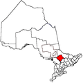 | |
|---|---|---|
| Townships | ||
| Villages | ||
| First Nations | ||
| Indian reserves | ||
| Local services boards | ||
| Unorganized areas | ||
| ||