Chapakot Municipality
| Chapakot Municipality चापाकोट नगरपालिका | |
|---|---|
| Municipality | |
 | |
 Chapakot Municipality Location in Nepal | |
| Coordinates: 27°54′N 83°49′E / 27.90°N 83.82°ECoordinates: 27°54′N 83°49′E / 27.90°N 83.82°E | |
| Country |
|
| Zone | Gandaki Zone |
| District | Syangja District |
| Population (2011) | |
| • Total | 12,742 |
| Time zone | NST (UTC+5:45) |
| Website | www.chapakotmun.gov.np |
Chapakot is a municipality in the southeastern part of Syangja District in the Gandaki Zone of central Nepal. The new municipality was formed by merging three existing villages—Ratnapur, Kuwakot and Chapakot—on 18 May 2014.[1][2] The office of the municipality is that of the former Chapakot village development committee.
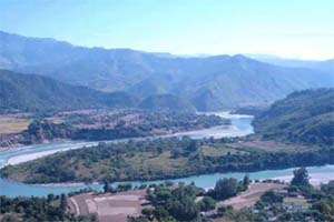
At the time of the 2011 Nepal Census Chapakot village had a population of 4,702 people living in 1087 individual households.[3] But now had a total population of 12,742 people living in 2,902 individual households when Ratnapur and Kuwakot VDCs merged with Chapakot. It is on a plain surrounded by hills. To the east of Chapakot was Ratnapur VDC; to the west was Kuwakot VDC. The Kali Gandaki divides it from Palpa District to the south, and to the north is Keware Bhanjyang.
References
- ↑ "72 New Municipalities Announced Archived June 18, 2014, at the Wayback Machine.", Republica, 8 May 2014.
- ↑ "Govt Announces 72 New Municipalities, The Kathmandu Post, 8 May 2014.
- ↑ "National Population Census 2011 - Ward Level" (PDF). Central Bureau of Statistics. Archived from the original (PDF) on 2014-10-26.