Changi Airport MRT Station
CG2 Changi Airport 樟宜机场 சாங்கி விமானநிலையம் Changi Airport | |||||||||||
|---|---|---|---|---|---|---|---|---|---|---|---|
| Rapid transit | |||||||||||
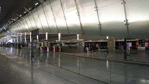 Changi Airport station platform level. | |||||||||||
| Location |
70 Airport Boulevard Singapore 819661 | ||||||||||
| Coordinates | 1°21′26.54″N 103°59′19.81″E / 1.3573722°N 103.9888361°E | ||||||||||
| Operated by | SMRT Trains (SMRT Corporation) | ||||||||||
| Line(s) | |||||||||||
| Platforms | Island | ||||||||||
| Tracks | 2 | ||||||||||
| Connections | Bus, Taxi | ||||||||||
| Construction | |||||||||||
| Structure type | Underground | ||||||||||
| Platform levels | 3 (excluding street level) | ||||||||||
| Parking | Yes (Changi Airport) | ||||||||||
| Bicycle facilities | Yes (Changi Airport) | ||||||||||
| Disabled access | Yes | ||||||||||
| Other information | |||||||||||
| Station code | CG2 | ||||||||||
| History | |||||||||||
| Opened | 27 February 2002 | ||||||||||
| Electrified | Yes | ||||||||||
| Services | |||||||||||
| |||||||||||
| Location | |||||||||||
 | |||||||||||


Changi Airport MRT Station (CG2) is an underground Mass Rapid Transit terminal station on the East West Line in Changi, Singapore. The station is located within Singapore Changi Airport, hence its name.
The station was opened on 25 February 2002, while the ceremony held on 27 February 2002 by the then Minister for Transport, Mr Yeo Cheow Tong as one of the terminal Mass Rapid Transit (MRT) stations for the East West Line, and located in between Singapore Changi Airport's Terminal 2 and Terminal 3.
Some of the facts about Changi Airport MRT Station:
- This is one of the four MRT stations that have fare gates on the same level as the platform. The three other MRT stations which have this feature are Expo (lift concourse), Bishan (Exit E at south-bound train platform), and Stevens (both platforms on the Downtown Line).
- The station is the easternmost station on the MRT network and has the widest platforms in any underground MRT station in Singapore of which it is 26.5 meters wide. It is rated 10 out of 15 most beautiful subway stops in the world in 2011.[1]
- This station has a list of every hotel in Singapore as well as the closest MRT station to these places. This is because Changi Airport MRT Station staff often receive queries on hotel locations.[2]
History
Changi Airport had been operating since its opening in 1981 with no rail link and with full reliance on taxi and bus connections, proven effective given the short 20 kilometre distance to the city via the East Coast Parkway and their relative affordability. Public buses also provide cheap express trips to the city, and link commuters to the MRT network at Bedok, Tampines and Pasir Ris. There was thus no pressing need to build the rail line despite regional competition, and was only given the green light when the Singapore Expo was built along the line and helping to add potential traffic.
The earlier plans had long been made for a new line branching off from the existing East West Line at Tanah Merah, with some conceptual plans showing a tentative route alignment up to the airport along Airport Boulevard, continuing beyond the airport to Changi Point, before turning southwest back towards the city along the east coast of the island. When the extension to the airport was finally announced, however, the route alignment showed a deviation from previous plans.
The final plan involved building only the first two stations, namely Expo, an elevated station directly adjacent to the Singapore Expo, and the Changi Airport station, an underground station built between Terminal 2 and Terminal 3. The alignment of the station at the airport has been switched perpendicularly to an east–west direction, such that the station leads to two of the terminals directly from either end of the station. And finally when the Singapore Expo opened in 1999, the Somapah MRT station was renamed to Expo.
Since the station's opening, passenger traffic has been moderate, as most bus routes were maintained and continue to be a popular means of cheap, direct transport for local airport/airline employees, as well as travellers not living along the East West Line. Route 34, as a peak-hour bus service was withdrawn on September 2002, together with the shortening of route 506 to Bedok (to replace the slot that is used for route 34). Route 989 was merged with 185 and cut short to Lorong 1 Geylang. A new bus service, 34 from Punggol to Changi Airport took over the slot in Changi Airport Bus Terminal to enhance connectivity along Tampines East, Tampines new town, IKEA Tampines and Punggol areas. Many air travellers also prefer to continue taking taxis or private transport as all the MRT services does not have luggage racks. Peak hours in Changi Airport Line are defined according to the flight schedules. Thus primary users of the station are usually confined to airport/airline employees, leisure visitors, well-wishers, and budget air travellers, in particular backpackers. This station receives a huge load of traffic during weekends due to the transfer point for commuters from Expo to the bus terminal.
Initially operated as a shuttle service, through services from Boon Lay were commenced after the full opening, but the service was reverted into shuttle mode from July 22, 2003.
The initial numbering of the station was EW29, but was changed on 20 June 2003 to CG2. The original code is now used for the Joo Koon station.
Proposal of line extension
A proposal for adding an extra station for the upcoming Changi Airport Terminal 5 (CG3) could be added to the Changi Airport branch line, where the Thomson East-Coast Line might terminate in future as an extension from Sungei Bedok Station.
This station might be an interchange station for both Changi Airport branch line and Thomson East-Coast Line in the future.
Station layout
| L2 | Departure Hall | Exits to Terminal 2 and 3, Skytrain to Terminal 1 |
| L1 | Arrival Hall | Exits to Terminal 2 and 3 |
| M | Linkbridge | Changi Airport PTB 2 and 3 Bus Terminal, Link bridge between Terminals 2 and 3, Exit to Terminal 3 |
| P Platforms | ||
| Faregates, Ticketing Machines, Station Control, Transitlink Counter | ||
| Platform A | East West Line towards EW4 Tanah Merah via CG1 DT35 Expo (←) | |
| Platform B | East West Line towards EW4 Tanah Merah via CG1 DT35 Expo (←) | |
Transport connections
Rail
| Destination | First Train | Last Train | ||||
|---|---|---|---|---|---|---|
| Mon – Sat | Sunday & Public Holiday | Daily | ||||
| East West Line | ||||||
| to EW4 Tanah Merah | 5.31am | 5.59am | ||||
| to EW1 Pasir Ris | – | – | 11.55pm | |||
| to EW24 Jurong East | – | – | 11.18pm | |||
| to EW29 Joo Koon | – | – | 10.54pm | |||
References
- ↑ "15 of the Most Beautiful Subway Stops in the World, BootsnAll Travel Guide".
- ↑ "Station Stories: Changi Airport MRT Station". The SMRT Blog. 28 April 2015. Retrieved 30 April 2016.