Chanderi
| Chanderi چندےري चन्देरी | |
|---|---|
| Town | |
|
View of Chanderi town from Qila Kothi. The Chaubisi Jain temple with 24 shikharas, installed in 1836 by Bhattaraka Harichand of Sonagir, is in the center. | |
| Nickname(s): ऐतिहासिक नगरी चंदेरी | |
 Chanderi Location in Madhya Pradesh, India | |
| Coordinates: 24°43′N 78°08′E / 24.72°N 78.13°ECoordinates: 24°43′N 78°08′E / 24.72°N 78.13°E | |
| Country |
|
| State | Madhya Pradesh |
| District | Ashok Nagar |
| Founded by | Raja Shishupal (mentioned in Mahabharata) |
| Named for | Chedi Kingdom |
| Government | |
| • Type | City Municipality Board |
| Area | |
| • Total | 10.7 km2 (4.1 sq mi) |
| Elevation | 456 m (1,496 ft) |
| Population (2011) | |
| • Total | 33,081[1] |
| • Rank | 3rd in Ashoknagar District |
| Languages | |
| • Official | Bundelkhandi, Urdu |
| Time zone | IST (UTC+5:30) |
| Telephone code | 07547 |
| Vehicle registration | MP 67 |
| Website | chanderi.nic.in |

Chanderi (Hindustani: चंदेरी (Devanagari), چندیری (Nastaleeq)) is a town of historical importance in Ashoknagar District of the state of Madhya Pradesh in India. It is situated at a distance of 127 km from Shivpuri, 37 km from Lalitpur, 55 km from Ashok Nagar and about 45 km from Isagarh. It is surrounded by hills southwest of the Betwa River. Chanderi is surrounded by hills, lakes and forests and is spotted with several monuments of the Bundela Rajputs and Malwa sultans.
Jainism at Chanderi
The Chanderi area has been a major center of Jain culture. It was a major center of the Parwar Jain community. There are a number of Jain places nearby- Gurilagiri (7 km), Aamanachar (29 km), Bithala (19 km), Bhamon (16 km), Khandargiri (2 km), Thuvanji (22 km) and Bhiyadant (14 km), and Deogarh, Uttar Pradesh (20 km, across the border).
At a distance of 19 km from present Chanderi town is situated the Buddhi (old) Chanderi. Buddhi Chanderi is situated on the banks of Urvashi river. It is believed that the Chaidnagar mentioned in Puranas is same as Buddhi Chanderi. There is a myth that when Raja Nala left Damayanti asleep in the forests of Narwar she moved through dense forests and reached Chaidnagar protecting herself from wild animals. The route through forests from Narwar to Chanderi is very short. A number of 9th and 10th century Jain temples are there in Buddhi Chanderi attracting thousands of Jain pilgrims from all over the country.
The Jain Bhattarakas of Mula Sangh, Balatkara Gana had a center at Chanderi that flourished for several centuries. The lineage, as constructed by Pt. Phulachandra Shastri is as following:

- Devendrakirti (see Balatkara Gana), who awarded Singhai title in 1436 CE (see Parwar (Jain))
- Tribhuvanakirti (anointed in Vikram Samvat 1522),
- Sasasrakirti
- Padmanandi
- Yashahkirti
- Lalitkirti
- Dharmakirti
- Padmakirti (died Vikram Samvat 1717)
- Sakalakirti
- Surendrakirti (pratishtha in Vikram Samvat 1746)
A branch of this lineage continued at Sironj.
- Jagatkirti (pupil of Dharmakirti above)
- Tribhuvanakirti
- Narendrakirti
- Unknown
- Rajkirti
- Devendrakirti (pratishtha in samvat 1871)
- Jain Temple
List of Jain temples at Chanderi:[2]
- Shri Choubeesee Bara Mandir : This temple has 2 parts with front part is known as Bara mandir and back part called Choubeesee mandir. As suggested by inscription this temple was built around year 1293(V.S. 1350). This temple was renovated in 13th to 18th century. This temple has 24 idols for 24 tirthankars and these idols are made by the stones of actual colors as the Teerthankar. All idols are same in dimensions, which is very difficult in real.[3][4]
- Shri Khandargiri Jain temple : It is one of the most famous religious site in Chanderi. This temple is famous for 45 feet carved idol of Rishabhnatha. Inscriptions suggest that this statue is over 700 years old.[5] Six caves have been cut out of the hillside. Inside there are a number of religious carvings of Jain saints and decorations carved into the existing hillside. The oldest cave is cave 6 that dates back to 1236.[6]
- Shri thobonji Jain temple : This temple belongs to 9th century.[7] Moolnayak of this temple is light blue colored idol colossal of Adinath of height 36 feet 8 inches. The other colossal idols in this temple are Bhagwan Parshwanatha of height 13 feet 4 inches and Bhagwan Parshwanath of height 12 feet 6 inches.[8]
- Shri Chandraprabha digambar Jain temple : This temple is dedicated to Chandraprabha, the 8th tirthankar of Jainism. Oldest inscription date back to year 967 AD.[9]
History
Chanderi is located strategically on the borders of Malwa and Bundelkhand. History of Chanderi goes back to the 11th century, when it was dominated by the trade routes of Central India and was proximate to the arterial route to the ancient ports of Gujarat as well as to Malwa, Mewar, Central India and the Deccan. Consequently, Chanderi became an important military outpost. The town also finds mention in Mahabharata. Shishupal was the king of Chanderi during the Mahabharata period.
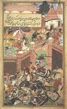
Chanderi is mentioned by the Persian scholar Alberuni in 1030. Ghiyas ud din Balban captured the city in 1251 for Nasir ud din Mahmud, Sultan of Delhi. Sultan Mahmud I Khilji of Malwa captured the city in 1438 after a siege of several months. In 1520 Rana Sanga of Mewar captured the city, and gave it to Medini Rai, a rebellious minister of Sultan Mahmud II of Malwa. In the Battle of Chanderi, the Mughal Emperor Babur captured the city from Medini Rai and witnessed the macabre Rajput rite of jauhar, in which, faced with certain defeat and in an attempt to escape dishonor in the hands of the enemy, women with children in their arms jumped in a fire pit to commit suicide,which was made for this specific purpose,against the background of vedic hymns recited by the priests.Jauhar was performed during the night and in the morning the men would rub the ashes of their dead women folk on their forehead,don a saffron garment known as kesariya,chew tulsi leaves (in India tulsi leaves are placed in the mouth of a dead body),symbolizing their awareness about impending death and resolve to fight and die with honour.This method of fighting & dying for the cause of retaining honour was called "SAKA".[10]
In 1540 it was captured by Sher Shah Suri, and added to the governorship of Shujaat Khan. The Mughal Emperor Akbar made the city a sarkar in the subah of Malwa.[11] According to Ain-e-Akbari, the autobiography of Akbar, Chanderi had 14000 stone houses and boasted of 384 markets, 360 sapcious caravan sarais (resting place) and 12,000 mosques.
The Bundela Rajputs captured the city in 1586, and it was held by Ram Sab, a son of Raja Madhukar of Orchha. In 1680 Devi Singh Bundela was made governor of the city, and Chanderi remained in the hands of his family until it was annexed in 1811 by Jean Baptiste Filose for the Maratha ruler Daulat Rao Sindhia of Gwalior. The city was transferred to the British in 1844. The British lost control of the city during the Revolt of 1857, and the city was recaptured by Sir Hugh Rose on 14 March 1858. Richard Harte Keatinge led the assault, for which he was awarded the Victoria Cross. The city was transferred back to the Sindhias of Gwalior in 1861, and became part of Isagarh District of Gwalior state.
After India's independence in 1947, Gwalior became part of the new state of Madhya Bharat, which was merged into Madhya Pradesh on 1 November 1956.
Geography
Chanderi is located at 24°43′N 78°08′E / 24.72°N 78.13°E.[12] It has an average elevation of 456 metres (1496 feet).
coor title dms|24|43|12|N|78|07|48|E
Demographics
As of 2001 India census,[13] Chanderi had a population of 28,313. Males constitute 52% of the population and females 48%. Chanderi has an average literacy rate of 62%, higher than the national average of 59.5%; with male literacy of 72% and female literacy of 52%. 17% of the population is under 6 years of age.
Places of interest
- Shri Choubeesee Bara Mandir
- Shri Khandargiri Jain temple
- Shri thobonji Jain temple
- Shri Chandraprabha digambar Jain temple
- Bawari masjid
- Jami Masjid, Chanderi
- kati ghati
- battesi wabri
- koshiq mahal
- Shahzadi ka Rauza
- Jageswari devi Temple
- Chanderi Museum
- Khandar Giri Atishay Khetra
- Malan Kho
- Baiju Bawra's Samadhi(Cenotaph)
- Janki Nath Temple[14]
Access
There is a good roadway network in Chanderi. The town lies at State Highway 20 with connections to Ashoknagar, ISHAGARH, Lalitpur etc. There is no Railway line in Chanderi neither nearby. A proposed Railway line was enacted in 2014 as Pipraigaon-Chanderi-Lalitpur line of Northern Railways, Which will be in progress soon.[15]
One can easily visit Chanderi via
- Lalitpur 40 km from Chanderi. Well connected by road Lalitpur is situated on the Bhopal-Jhansi railway route and is also a stop for a number of important trains.
- Mungaoli 38 km from Chanderi. Mungaoli is well connected by road and is situated on the Bina-Kota railway route. Many passenger trains and few express like the Sabarmati exppress, Dayoday express, Okha-Gorakhpur, Ujjaini express, Bhopal-Gwalior express halt at the Mungaoli station.
- Ashok Nagar 65 km from Chanderi. Situated on the Bina-Kota railway route many passenger trains and express trains from Bina Etawa and Kota halt at Ashoknagar.
See also
References
- Hunter, William Wilson, James Sutherland Cotton, Richard Burn, William Stevenson Meyer, eds. (1909).
- Imperial Gazetteer of India, vol. 9. Oxford, Clarendon Press.
- ↑ http://www.census2011.co.in/data/town/802407-chanderi.html
- ↑ "Jainism at Chanderi". http://chanderi.net. External link in
|publisher=(help) - ↑ http://jainteerth.com/madhya-pradesh-m-p-jain-teerth/shri-digamber-jain-atishaya-kshetra-choubeesee-bara-mandir-chanderi/
- ↑ http://jain.org.in/tirth-Chanderi,%20M.P.html
- ↑ http://chanderi.org/2010/05/05/khandargiri-temple/
- ↑ http://www.mptourandtravels.com/Place_Of_Interest_Chanderi4.aspx
- ↑ http://www.mptourandtravels.com/Place_Of_Interest_Chanderi4.aspx
- ↑ http://www.jainheritagecentres.com/Madhyapradesh/Thuvanji.htm
- ↑ http://chanderi.org/2010/05/05/chandraprabh-jain-temple/
- ↑ The Mughal Throne by Abraham Eraly pg 33
- ↑ Abū al-Fazl ibn Mubārak, The Ain - I - Akbari, Volume 2, page 196
- ↑ Falling Rain Genomics, Inc - Chanderi
- ↑ "Census of India 2001: Data from the 2001 Census, including cities, villages and towns (Provisional)". Census Commission of India. Archived from the original on 2004-06-16. Retrieved 2008-11-01.
- ↑ "Archived copy". Archived from the original on 2010-11-16. Retrieved 2010-11-23.
- ↑ http://m.indiarailinfo.com/news/post/pipraigaon-and-lalitpur-via-chanderi/116322
External links
| Wikimedia Commons has media related to Chanderi. |
- Shri Digamber Jain Atishaya Kshetra Choubeesee Bara Mandir, Chanderi
- Shri Digamber Jain Atishaya Kshetra Khandargiri
- Shri Digamber Jain Atishaya Kshetra Thuvonji
- Chanderi Geographical Index Website
- Film on the master weavers of Chanderi
- Chanderi: Travel Guide Goodearth Publications, New Delhi, 2006. (ISBN 978-81-87780-96-0)