Chama, Zambia
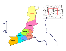
Chama is a small town in the Muchinga Province of Zambia, and is headquarters of Chama District. It is one of the most remote district headquarters in the country, lying just inside the eastern edge of the upper Luangwa Rift Valley, at the foot of the highlands dividing Zambia and Malawi. It is served by only one gravel road which comes from Lundazi and the provincial capital, Chipata, 300 km to the south. A dirt track connects the town to the South Luangwa National Park 200 km south-west, running parallel to the Luangwa River. There are no roads west from Chama across the Luangwa Valley, but a little-used dirt track follows the Malawi border further north and crosses into Isoka District west of the Nyika Plateau.
References
- General references
- Google Earth
- Terracarta/International Travel Maps, Vancouver Canada: "Zambia, 2nd edition", 2000
Coordinates: 11°13′S 33°09′E / 11.217°S 33.150°E