Chain of Rocks Bridge
| Chain of Rocks Bridge | |
|---|---|
 | |
| Coordinates | 38°45′38″N 90°10′35″W / 38.76056°N 90.17639°W |
| Carries | Pedestrians and bicycles (1998-present) |
| Crosses | Mississippi River |
| Locale | St. Louis, Missouri / Madison, Illinois |
| Maintained by | Trailnet |
| Characteristics | |
| Design | Cantilever through-truss |
| Total length | 5,353 feet (1,632 m) |
| Width | 24 feet (7 m) |
| Longest span | 700 feet (213 m) |
| History | |
| Opened | 1929 |
| Closed |
1970 (vehicle traffic) |
|
Chain of Rocks Bridge | |
  | |
| Location | West Chain of Rocks Rd., Madison, Illinois |
| Area | 12.6 acres (5.10 ha) |
| Built | 1929 |
| Architect | Brown, Baxter L.; et al. |
| Architectural style | Warren Truss |
| MPS | Route 66 through Illinois MPS |
| NRHP Reference # | 06001091[1] |
| Added to NRHP | December 01, 2006 |
The Chain of Rocks Bridge spans the Mississippi River on the north edge of St. Louis, Missouri. The eastern end of the bridge is on Chouteau Island, (part of Madison, Illinois), while the western end is on the Missouri shoreline.
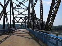
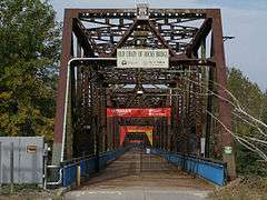
The bridge was for a time the route used by U.S. Route 66 (US 66) to cross over the Mississippi. Its most notable feature is a 22-degree bend occurring at the middle of the crossing. Originally a motor route, the bridge now carries walking and biking trails over the river. A new Chain of Rocks Bridge carries vehicular traffic to the north. The old route to the bridge is now called Chain of Rocks Road and ends near Roman Road. Parking is available at the start of the now pedestrian route. The bridge was added to the National Register of Historic Places in 2006.[2]
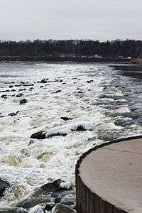
The bridge's name comes from a large shoal, or rocky rapids, called the Chain of Rocks, which made that stretch of the Mississippi extremely dangerous to navigate.[3] Because of a low-water dam built by the Corps of Engineers in the 1960s, little of the Chain of Rocks is visible today except during extreme low water conditions.[4] After 1940, only a single impediment prevented the maintenance of a safe and reliable 9-foot (2.7 m) navigation channel on the Mississippi River from St. Paul, Minnesota, to New Orleans. This impediment, known as the Chain of Rocks Reach, was a 17-mile (27 km) series of rock ledges that began just north of St. Louis and was extremely difficult and dangerous to navigate. In the late 1940s and early 1950s the U.S. Army Corps of Engineers built a 8.4-mile-long (13.5 km) canal to bypass this treacherous reach. To ensure adequate depths in the pool below the old Lock and Dam 26, a non-movable, low water dam was constructed just downstream of the old bridge and a lock was installed at the south end of the canal. Known respectively as Dam No. 27, also called Chain of Rocks Dam, and Locks No. 27, or Chain of Rocks Lock.[3][5]
History
The area was chosen as a site for the St. Louis waterworks in 1865, with construction beginning in 1887, and the water plant opened in 1894. A filter plant was added in 1915, which at the time of its construction was the largest filter plant in the world.[4] The Chain of Rocks Bridge was privately built as a toll bridge in 1929 at a cost of $3 million and later turned over to the city of Madison, Illinois, the current owner of the bridge. Though engineers predicted ten fatalities during the creation of the bridge, only one worker was killed. In the late 1930s, Bypass US 66 was designated over this bridge and around the northern and western parts of St. Louis to avoid the downtown area (City US 66 continued to cross the Mississippi River over the MacArthur Bridge). On August 2, 1966, the tolls were suspended by the City of Madison, which marked an end of the struggle with the state of Missouri over tolls.[6] In 1966, the New Chain of Rocks Bridge was built immediately to the bridge's north in order to carry I-270; the Chain of Rocks Bridge was subsequently closed on February 25, 1970.[7]
For nearly three decades the fate of the bridge was uncertain, though demolition seemed its most likely end. The high cost of demolition, however, indefinitely delayed that outcome until a new use was found. During this time, the bridge developed a reputation for crime and violence, including the April 1991 murder of sisters Julie and Robin Kerry. It was used as a filming site for Escape from New York in 1981, with the bridge being used as the "69th Street Bridge".[8]
In 1998, the bridge was leased to Trailnet, a local trails group, to operate.[9] Four-and-a-half million dollars have been spent on renovating the bridge for pedestrian and cycling use.[10]
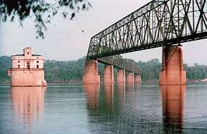
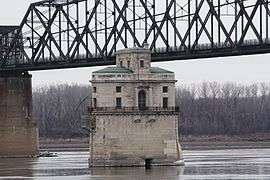
From the Illinois side of the bridge, signs marked "HISTORIC ROUTE 66 SPUR" take travelers to the Illinois side of the bridge and a "HISTORIC ROUTE 66" sign marks the Missouri side of the bridge. The Gateway Arch is visible downriver, and immediately downstream from the bridge, two water intakes for the St. Louis Waterworks are visible. One is vaguely Gothic Revival in style; the other closely echoes Roman ruins from Trier in modern Germany.
As of February 2011, the east (Illinois) entrance to the bridge has been repainted green. It is not known whether or not the rest of the bridge will be repainted in the near future. The bridge is made of steel and concrete.
Gallery
-
Water intake with one span of the Chain of Rocks Bridge
-

Water intake near Chain of Rocks Bridge
-
View on the bridge
-
Illinois entrance to bridge
-
Low-water River Dam #27
-

Just inside Illinois entrance to bridge
-

Close-up photo of 22-degree bend
See also
- List of crossings of the Upper Mississippi River
- Chain of Rocks Lock
- Chain of Rocks Amusement Park
- Marlin Gray
References
- ↑ National Park Service (March 13, 2009). "National Register Information System". National Register of Historic Places. National Park Service.
- ↑ "National Register of Historic Places Registration Form" (PDF). Missouri Department of Natural Resources. April 4, 2006. Retrieved January 17, 2010.
- 1 2 St. Louis District (June 7, 2006). "Locks 27 and the Chain of Rocks Dam". U.S. Army Corps of Engineers. Archived from the original on November 21, 2009. Retrieved January 17, 2010.
- 1 2 "The Chain of Rocks Plant". City of St. Louis Water Division. 2005. Retrieved January 17, 2010.
- ↑ "Locks #27 and Chain of Rocks Dam". Great River Road. Retrieved January 17, 2010.
- ↑ Alton Evening Telegraph. August 2, 1966. Missing or empty
|title=(help) - ↑ Alton Evening Telegraph. February 26, 1970. Missing or empty
|title=(help) - ↑ "Old Bridge Used for Filming 'Escape'". Granite City Press Record. August 28, 1980.
- ↑ "Archived copy". Archived from the original on 2006-10-08. Retrieved 2007-03-19.
- ↑
External links
- Trailnet (organization which operates the Bridge)
- High resolution panoramic image taken from the bridge deck
| Crossings of the Mississippi River | ||||
|---|---|---|---|---|
| ||||
| Topics | |
|---|---|
| Lists by states |
|
| Lists by insular areas | |
| Lists by associated states | |
| Other areas | |
| |