Chaguaramas, Trinidad
| Chaguaramas | |
|---|---|
| Town | |
|
Hart's Cut Bay in Chaguaramas | |
| Corporation | Diego Martin Regional Corporation |
| Country | Trinidad and Tobago |
| Ranked | |
| Time zone | AST (UTC−4) |
| Area code(s) | 634 |

Chaguaramas (pronounced, in the local English dialect, "shag-gah-rah-muss") lies in the North West Peninsula of Trinidad west of Port of Spain; the name is often applied to the entire peninsula, but is sometimes used to refer to its most developed area. The developed area in Chaguaramas starts at ALCOA and ends at the Army and Coast Guard camps on the mainland. In the description or context of "developed area" one excludes the five islands which are in various stages of development or redevelopment as of 2016. However in the information below, some data is included on the Five Islands (5 Islands)
Most of the roadway in Chaguaramas lies close to the coast line and one can view the sea from the winding road. According to Google Maps, Chaguaramas is about fourteen kilometres (14 km) from Port of Spain.[1]
Leasing of Chaguaramas to the United States
The entire peninsula was leased to the United States in 1940 for the construction of a naval base under the Destroyers for Bases Agreement.
The base was also used during the early 1960s as a BMEWS early warning radar site, as well as a missile tracking site on the U.S. Air Force Eastern Test Range. The base was scaled back in 1956 and the area was returned to Trinidad and Tobago control in 1963.[2][3]
Treaty of Chaguaramas/CARICOM
Chaguaramas was the location slated for the construction of the capital of the short-lived West Indies Federation. It is also the place where the Treaty of Chaguaramas was signed, establishing Caricom, the Caribbean Community and Common Market, in 1973.
Activities and Places of Interest
Dry Forests
The Chaguaramas Peninsula supports one of the few remaining areas of dry forest in western Trinidad.
Cycling and Kayaking
On weekends groups of persons enter Chaguaramas to cycle on or kayak [4] in rented equipment. During the week, the roadway is used as a training ground for persons who cycle [5] in groups either for sport or as a part of a training session for a Tri-athalon.
The Chaguaramas Boardwalk Area
The Chaguaramas Boardwalk was developed by the Chaguaramas Development Authority (CDA)[6] as part of its tourism developmental thrust. The Boardwalk stretches for approximately 1300 feet [7] along the shore of one of the Bays. The Boardwalk can be used as an exercise route for pedestrians or for young families who stroll or as a stepping stone to get to the water to swim for leisure or as part of a training regimen.
Available in close proximity to the Boardwalk are Gazebos and Pedal Boats which are available for rent. There is also the Dancing Water Fountain, the Trees Vendor Plaza and Miniature Off Road Activities according to the CDA's website.[8]
Chaguaramas Golf Course
The Chaguaramas Golf Course is "a 9-hole course" and the only "public" golf course in the twin-island Republic. The Golf Course at Chaguaramas has been in existence for some forty plus (40+) years and is one of the older, if not the oldest golf course in the island.[9]
Pier 1
Pier 1 was designed to host functions for large numbers of persons. The venue was designed to host events in small areas within a larger setting, thus it can serve a large number of persons with different tastes through the use of the smaller areas as niche spots.[10]
Yacht
CHaguaramas has been the center of yachting activity in Trinidad. There are several marinas [11] within the Chaguaramas area which provide repair services or on-land boarding services for yachts. There is also the option to refuel and stock supplies or just moor the yacht at a pier or in a sheltered bay facility and visit the island.
Heritage Parks, Macqueripe and The Magnificent Edith Falls
According to the CDA, the Gasparee Cave on Gasparee Island,[12] along with the Salt Pond on Chacachacare and the Bellerand Heritage Park fall within the boundaries of Chaguaramas.[13] Although Gasparee has been developed with housing facilities, to a large extent efforts have been made to preserve the birds on the island, through the "upkeep" of the large trees which provide shelter at great heights for them.
"Conveniently located just off the Macqueripe Road, Bellerand Heritage Park is surrounded by various areas offering recreational activities such as golfing, swimming and is a 'stone's throw' away from the Magnificent Edith Falls".[14] Another heritage park which is located within the Macqueripe area in Chaguaramas is Samaan Park.
At Macqueripe, one is allowed to swim in the sea as the area is located in an inlet. However great care should be exercised in entering and exiting the water as due to dredging of the sea bed many years ago, there is a sharp descent of several feet close to the shore. The drop/ or descent can make the area perilous for newly trained swimmers and the extremely short person entering or exiting the water.
Tucker Valley
Tucker Valley is known for several points of interest such as: The Bamboo Cathedral [15] The UPick Farm, The World War Bunker and The Nutmeg Grove [16] among other things.
The Bamboo Cathedral is well known by photographers who capture images of many newly engaged couples strolling in the area. The wide lane of the roadway with the bamboos intertwining overhead creates an image of seclusion and sets the tone for newly engaged wonder!
The UPick Farm "sells a wide range of fruits and vegetables (grown off-site) both local and imported".[17] Also available at the UPick Farm are guided tours and field trips for primary and secondary school children.
DockSide Facilities
The Chaguaramas area also contains some dockside facilities, mostly for the transfer of bauxite ore between ship and shore, or from smaller boats to ocean-going vessels. The function of such docks is easily recognizable as the docks and buildings are colored pink from the bauxite dust.
The waterways in this area are considered excellent by divers and fishermen.
Gallery
-

Looking West across Williams Bay during Dragon Boat racing in Chaguaramas, Trinidad and Tobago
-

A Drydock in Chaguaramas
-
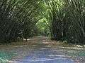
The "Bamboo Cathedral" on the road to the Tracking Station in Chaguaramas
-

A warehouse harbour in Chaguaramas
Further reading
Transatlantic Sketches, Comprising Visits to the Most Scenes in North and South, by Sir Richard Alexander. Published 1833, R. Bentley, Original from the University of Michigan. Digitized September 20, 2006, by Google. (See Chapter XIII.)
External links
- Diving around Trinidad - Down The Islands, Chaguaramas
- Chaguaramas, Trinidad and Tobago travel blogs - travel stories and ...
- Destroyers for Bases Agreement, 2 September 1940
- The ‘Town’-Class Destroyers
- The Cove - Chaguaramas
References
- ↑ Directions from POS http://www.distancesfrom.com/tt/directions-from-Port-of-Spain-to-Chaguaramas/DirectionHistory/7775236.aspx
- ↑ Chaguaramas History at the Chaguaramas Development Authority Archived August 20, 2008, at the Wayback Machine.
- ↑ http://chaguaramas.com/discovery-zone/chaguaramas-history/march-on-chaguaramas
- ↑ Discover TT http://www.discover-tt.net/marinas/kayaking.html
- ↑ Trini Outdoors http://www.trinoutdoors.com/pages/trinidad_cycling_areas.htm
- ↑ CDA http://chaguaramas.com/
- ↑ Business Guardian http://www.guardian.co.tt/business-guardian/2012-03-29/under-chaguaramas-boardwalk
- ↑ CDA Things to Do http://chaguaramas.com/things-to-do/boardwalk
- ↑ CDA Golf Course http://chaguaramas.com/things-to-do/golf-course
- ↑ http://www.discovertnt.com/articles/Trinidad/Touring-Trinidad-pt-4-the-Northwest-Peninsula/167/3/23#axzz4BEltV7t3
- ↑ Carnaval.Com Trinidad Chag http://www.carnaval.com/trinidad/chag/
- ↑ Perceptions - Sea visible on the Way to the Gasparee Caves, Trinidad and Tobago http://jennifernbailey245.blogspot.com/2015/09/perceptions.html
- ↑ Chaguaramas Info http://chaguaramas.com/about-cda/chag-info#in-chaguaramas
- ↑ CDA http://chaguaramas.com/things-to-do/heritage-parks
- ↑ http://www.trinoutdoors.com/pages/trinidad_cycling_areas.htm,
- ↑ Trin Tours http://www.trintours.com/cruisetrinidad.htm
- ↑ Trini Chow https://trinichow.com/2015/12/30/u-pick-farm-chaguaramas-trinidad/
Coordinates: 10°41′N 61°38′W / 10.683°N 61.633°W