Chaîne des Puys
| Chaîne des Puys | |
|---|---|
 View of the Chaîne des Puys from Puy de Dôme | |
| Highest point | |
| Elevation | max. 1,464 m (4,803 ft) at Puy de Dôme |
| Coordinates | 45°30′N 2°48′E / 45.5°N 2.8°E |
| Geography | |
| Location | Auvergne-Rhône-Alpes, France |
| Parent range | Massif Central |
| Geology | |
| Age of rock | < 95,000 years |
| Mountain type | cinder cones, lava domes, and maars |
| Last eruption | 4040 BCE ± 150 years |
The Chaîne des Puys is a north-south oriented chain of cinder cones, lava domes, and maars in the Massif Central of France. The chain is about 40 km (25 mi) long, and the identified volcanic features include 48 cinder cones, eight lava domes, and 15 maars and explosion craters. Its highest point is the lava dome of Puy de Dôme, located near the middle of the chain. The name of the range comes from a French term, puy, that refers to a volcanic mountain with a rounded profile.
The chain is famous in the history of volcanology, as it was the subject of the pioneering research of English geologist George Julius Poulett Scrope, starting in the 1820s. In 1827 he published his classic Memoir on the Geology of Central France, including the Volcanic formations of Auvergne, the Velay and the Vivarais, which was later re-published in a revised and somewhat more popular form in The Geology and extinct Volcanos of Central France in 1858. These books were the first widely published descriptions of the Chaîne des Puys, and the analysis therein laid the foundation for many of the basic principles of volcanology.
A date of 4040 BCE is usually given for the last eruption of a Chaîne des Puys volcano.[1]
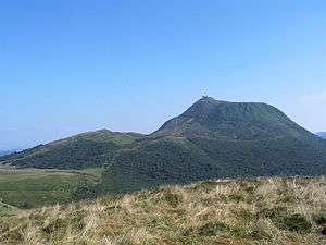 View of Puy de Dôme from the west
 Gour de Tazenat, a maar in the Chaîne des Puys.
 Relief Map
Sources
- ↑ "Chaine des Puys". Volcano World. Oregon State University. Retrieved 18 February 2016.
References
- Scrope, George Poulett (1858). The Geology and extinct Volcanos of Central France. J. Murray, London. p. 258. ISBN 0-405-10459-6. (reprinted in 1978 by Arno Press)
- Scarth, Alwyn; Tanguy, Jean-Claude (2001). Volcanoes of Europe. Oxford University Press. pp. 243 pp. ISBN 0-19-521754-3.
- Cattermole, Peter (2001). Auvergne (Classic Geology in Europe 2). Terra Publishing. pp. 176 pp. ISBN 1-903544-05-X.
- "Chaîne des Puys". Global Volcanism Program. Smithsonian Institution.
- "Chaîne des Puys - Synonyms & Subfeatures". Global Volcanism Program. Smithsonian Institution.
- Boivin Pierre; et al. (2004). Volcanologie de la Chaîne des Puys, Massif Central Français. Clermont-Ferrand: Parc Naturel Régional des Volcans d'Auvergne. OCLC 634970268.
| Wikimedia Commons has media related to Chaîne des Puys. |