Châteauneuf-de-Randon
| Châteauneuf-de-Randon | ||
|---|---|---|
|
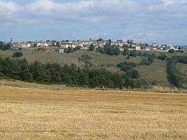
A general view of Châteauneuf-de-Randon | ||
| ||
 Châteauneuf-de-Randon | ||
|
Location within Occitanie region  Châteauneuf-de-Randon | ||
| Coordinates: 44°38′29″N 3°40′34″E / 44.6414°N 3.6761°ECoordinates: 44°38′29″N 3°40′34″E / 44.6414°N 3.6761°E | ||
| Country | France | |
| Region | Occitanie | |
| Department | Lozère | |
| Arrondissement | Mende | |
| Canton | Châteauneuf-de-Randon | |
| Intercommunality | Châteauneuf-de-Randon | |
| Government | ||
| • Mayor (2001–2008) | Pierre Bessière | |
| Area1 | 24.49 km2 (9.46 sq mi) | |
| Population (1999)2 | 532 | |
| • Density | 22/km2 (56/sq mi) | |
| Time zone | CET (UTC+1) | |
| • Summer (DST) | CEST (UTC+2) | |
| INSEE/Postal code | 48043 / 48170 | |
| Elevation |
1,116–1,339 m (3,661–4,393 ft) (avg. 1,286 m or 4,219 ft) | |
|
1 French Land Register data, which excludes lakes, ponds, glaciers > 1 km² (0.386 sq mi or 247 acres) and river estuaries. 2 Population without double counting: residents of multiple communes (e.g., students and military personnel) only counted once. | ||

Châteauneuf-de-Randon is a village and commune in the Lozère department in southern France.
History
The battle of Châteauneuf-de-Randon was fought in 1380 between the English and the French. In 1380 the fortress of Châteauneuf-de-Randon was besieged by the French, under the command of Bertrand du Guesclin, and the fortress was defended by an English garrison under De Ros. After a defence that obstinate, the town surrendered on 4 July. The siege, however, was fatal to the French commander.
Geography
The Chapeauroux forms part of the commune's western border, flows eastward through the middle of the commune, then forms part of its eastern border.
See also
External links
| Wikimedia Commons has media related to Châteauneuf-de-Randon. |