Cerro de las Mitras
| Cerro de las Mitras | |
|---|---|
 Cerro de las Mitras 2006 | |
| Highest point | |
| Elevation | 2000 |
| Coordinates | 25°42′25″N 100°24′47″W / 25.70694°N 100.41306°W |
| Naming | |
| Translation | Miter Hill (Spanish) |
| Geography | |
| Location | Nuevo León, Mexico |
| Climbing | |
| Easiest route | Hike |
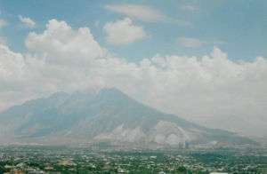
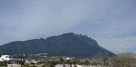
Cerro de las Mitras (literally 'Hill of the Mitres'), named for its distinctive mitre-shaped structures at the very top viewed from the northern side, is a symbol of the landscape of the state of Nuevo León, Mexico. Located in the cities of Monterrey, Santa Catarina and García.
Being part of the Cumbres national park, the mountain is often climbed by hikers. The ascent is considered fairly difficult. A panoramic view of the city of Monterrey can be seen from the top.
The south/southeast face of the mountain was a source of raw material for the local concrete manufacturers; the resulting pits are noticeable in the photos for their lighter gray colors.
Some other known mountains or elevations of the zone are: the Cerro de la Silla, the Sierra Madre Oriental and Cerro de Chipinque (with its famous M-shaped figure), the Cerro del Topo Chico, Cerro del Obispado, Cerro de la Loma Larga and La Huasteca.