Cerro de Arcos
| Cerro de Arcos | |
|---|---|
 A general view of the Cerro de Arcos (with Cerro de las Chinchas in the background) | |
| Highest point | |
| Elevation | 3,700 m (12,100 ft) |
| Coordinates | 03°33′51″S 79°28′10″W / 3.56417°S 79.46944°WCoordinates: 03°33′51″S 79°28′10″W / 3.56417°S 79.46944°W |
| Geography | |
 Cerro de Arcos | |
| Parent range | Andes |
| Geology | |
| Age of rock | Paleogene (Gomez 1994) |
| Mountain type | Rock formation |
| Climbing | |
| Easiest route | Hiking |
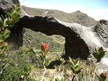
One of the arches
The Cerro de Arcos (English: Hill of arches) is a windswept rock formation in the high páramo of the Ecuadorian southern sierra. It is situated on the border between the provinces El Oro and Loja, on the elevated plain between the Cordillera de Chilla and the Cordillera de Timbayacu at an altitude of 3,700 m (12,140 ft).
The rock formation features towers, columns, and several of the eponymous arches formed by wind and weather erosion. The formation covers an area of about 300 m2 (3,200 sq ft).
Nearby populated places are Bellavista and Sabadel and the nearest villages or small towns are Zaruma and Manu.
References
- Gomez, Nelson (1994). Atlas del Ecuador. Editorial Ediguias. ISBN 9978-89-009-2.
- "Selva Alegre Ecuador, CT-NVI-D3". IGM. 1988. Retrieved 2008-01-26.
External links
This article is issued from Wikipedia - version of the 6/14/2016. The text is available under the Creative Commons Attribution/Share Alike but additional terms may apply for the media files.