Centre-Ouest Region
| Centre-Ouest | |
|---|---|
| Region | |
|
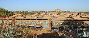
The Grand Marché in Koudougou, the region's largest urban center. | |
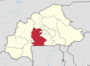 Location in Burkina Faso | |
| Coordinates: 11°45′N 2°15′W / 11.750°N 2.250°WCoordinates: 11°45′N 2°15′W / 11.750°N 2.250°W | |
| Country |
|
| Capital | Koudougou |
| Area | |
| • Total | 8,387 sq mi (21,722 km2) |
| Population (2011) | |
| • Total | 1,348,784[1] |
| Time zone | GMT 0 (UTC+0) |
Centre-Ouest is one of Burkina Faso's 13 administrative regions. The population of Centre-Ouest was 1,348,784 in 2011.[2] The region's capital is Koudougou. Four provinces (Boulkiemdé, Sanguié, Sissili, and Ziro) make up the region.
As of 2010, the population of the region was 1,310,644 with 53.92 per cent females. The population in the region was 8.33 per cent of the total population of the country. The child mortality rate was 61, infant mortality rate was 87 and the mortality of children under five was 142. As of 2007, the literacy rate in the region was 28.8 per cent, compared to a national average of 28.3 per cent. The coverage of cereal need compared to the total production of the region was 135.00 per cent.
Geography
Most of Burkino Faso is a wide plateau formed by riverine systems and is called falaise de Banfora. There are three major rivers, the Red Volta, Black Volta and White Volta, which cuts through different valleys. The climate is generally hot, with unreliable rains across different seasons. Gold and quartz are common minerals found across the country, while manganese deposits are also common.[3] The dry season is usually from October to May and rains are common during the wet season from June to September. The soil texture is porous and hence the yield is also poor.[4] The average elevation is around 200 m (660 ft) to 300 m (980 ft) above mean sea level. Among West African countries, Burkino Faso has the largest elephant population and the country is replete with game reserves.[5] The southern regions are more tropical in nature and have Savannah and forests. The principal river is the Black Volta, that originates in the southern region and drains into Ghana. The areas near the rivers usually have flies like tsete and similium, which are carriers of sleep sickness and river blindness.[3] The average rainfall in the region is around 100 cm (39 in) compared to northern regions that receive only 25 cm (9.8 in) rainfall.[5]
Demographics
As of 2010, the population of the region was 1,310,644 with 53.92 per cent females. The population in the region was 8.33 per cent of the total population of the country. The child mortality rate was 61, infant mortality rate was 87 and the mortality of children under five was 142.[6] As of 2007, among the working population, there were 59.30 per cent employees, 18.90 per cent under employed, 17.90 per cent inactive people, 21.80 per cent not working and 3.80 unemployed people in the region.[7] The main languages spoken in Centre-Ouest as of 2006 were Moore, Lyele, and Numi.[8] French is the official language throughout the country.[6]
Economy

The main road connecting the national capital, Ouagadougou, and Burkina Faso's second largest city Bobo-Dioulasso traverses the province (east to west). Burkina Faso's only railway connects the region's largest city, Koudougou with Ouagadougou, Bobo-Dioulasso and Ivory Coast. There is no commercial airport in the province but Ouagadougou International Airport is approximately 141km southeast of Koudougou and as of June 2014 the airport had regularly scheduled flights to most major cities in West Africa as well as Paris, Brussels and Istanbul. As of 2007, there were 678.1 km (421.4 mi) of highways, 231.8 km (144.0 mi) of regional roads and 634.7 km (394.4 mi) of county roads. The first set of car traffic was 38, first set of two-wheeler traffic was 3,166 and the total classified road network was 1,545.[9] The total corn produced during 2015 was 121,780 tonnes, cotton was 27,059 tonnes, cowpea was 49,972 tonnes, ground nut was 43,284 tonnes, millet was 72,426 tonnes, rice was 16,215 tonnes and sorghum was 260,885 tonnes. The coverage of cereal need compared to the total production of the region was 135.00 per cent.[10]
Education
As of 2007, the literacy rate in the region was 28.8 per cent, compared to a national average of 28.3 per cent. The gross primary enrollment was 83.7 per cent, pos-primary was 26.9 per cent and gross secondary school enrollment was 8.8. There were 898 boys and 473 girls enrolled in the primary and post-secondary level. There were 49 teachers in primary & post-secondary level, while there were 926 teachers in post-primary and post-secondary level.[11] Adult (15+) literacy in the region increased from 23,0% in 2003 to 28,3% in 2008.[12] In 2011 the region had 1,002 primary schools and 112 secondary schools. The University of Koudougou is also located in the region and had around 5,400 students in 2010/2011.[13] In 2010/11 10,1% of the population (aged 13-19) attended secondary school, which was below the national average of 10.7%.[14]
Provinces
| Province | Capital | 2006[15] |
|---|---|---|
| Boulkiemdé Province | Koudougou | 567,680 |
| Sanguié Province | Réo | 333,195 |
| Sissili Province | Léo | 240,830 |
| Ziro Province | Sapouy | 207,079 |
Burkina Faso got independence from French Colonial Empire during 1960. It was originally called Upper Volta. There have been military coups till 1983 when Captain Thomas Sankara took control and implemented radical left wing policies. He was outsed by Blaise Compaore, who continued for 27 years till 2014, when a popular uprising ended his rule.[16] As per Law No.40/98/AN in 1998, Burkina Faso adhered to decentralization to provide administrative and financial autonomy to local communities. There are 13 administrative regions, each governed by a Governor. The regions are subdivided into 45 provinces, which are further subdivided into 351 communes. The communes may be urban or rural and are interchangeable. There are other administrative entities like department and village. An urban commune has typically 10,000 people under it. If any commune is not able to get 75 per cent of its planned budget in revenues for 3 years, the autonomy is taken off. The communes are administered by elected Mayors. The communes are stipulated to develop economic, social and cultural values of its citizens. A commune has financial autonomy and can interact with other communes, government agencies or international entities.[17]
References
- ↑ "La région du Centre-Ouest en chiffres" (PDF). Institut National de la Statistique et de la Démographie (INSD). 2011. p. 6.
- ↑ "La région du Centre-Ouest en chiffres" (PDF). Institut National de la Statistique et de la Démographie (INSD). 2011. p. 6.
- 1 2 Haggett, Peter, ed. (2002). Encyclopedia of World Geography, Volume 17. Marshall Cavendish. ISBN 9780761473060.
- ↑ Dobson, James C.; Sander, John M.; Woodfield, Judith (2001). Living Geography: Homework and Assessment, Book 3. Nelson Thornes. p. 29. ISBN 9780174343257.
- 1 2 Burkina Faso Mining Laws and Regulations Handbook. Int'l Business Publications. 2008. p. 19. ISBN 9781433077074.
- 1 2 "Demographics of Burkina Faso". National Institute of Statistics and Demographics, Burkina Faso. 2010. Retrieved 17 November 2016.
- ↑ "Employment statistics of Burkina Faso". National Institute of Statistics and Demographics, Burkina Faso. 2007. Retrieved 17 November 2016.
- ↑ BOUGMA M., 2014. Dynamique des différentes langues en présence au Burkina Faso : les changements démo-linguistiques opérés au sein de la population burkinabè, 2014, Actes du XVIIe colloque international de l’AIDELF sur Démographie et politiques sociales, Ouagadougou, novembre 2012, 15 p.
- ↑ "Transport in Burkina Faso". National Institute of Statistics and Demographics, Burkina Faso. 2008. Retrieved 17 November 2016.
- ↑ "Agricultural statistics of Burkina Faso". National Institute of Statistics and Demographics, Burkina Faso. 2015. Retrieved 17 November 2016.
- ↑ "Education statistics of Burkina Faso". National Institute of Statistics and Demographics, Burkina Faso. 2010. Retrieved 17 November 2016.
- ↑ "La région du Centre-Ouest en chiffres" (PDF). Institut National de la Statistique et de la Démographie (INSD). 2011. p. 6.
- ↑ Government of France, MINISTERE DES AFFAIRES ETRANGERES ET EUROPEENNES, AMBASSADE DE FRANCE AU BURKINA FASO, FICHE BURKINA FASO, (French) http://www.diplomatie.gouv.fr/fr/IMG/pdf/BURKINA_18-5-11__2_.pdf
- ↑ "La région du Centre-Ouest en chiffres" (PDF). Institut National de la Statistique et de la Démographie (INSD). 2011. p. 6.
- ↑ "National 2006 census preliminary results" (PDF). 2006. Retrieved 24 November 2016.
- ↑ "Burkina Faso country profile". BBC. 5 August 2016. Retrieved 20 November 2016.
- ↑ Republic of Burkina Faso, Public Administration and Country profile (PDF) (Report). Department of Economic and Social Affairs (DESA), United Nations. 2004. p. 9. Retrieved 17 November 2016.