Central Artery
| Central Artery | |
|---|---|
| John F. Fitzgerald Expressway | |
 | |
| Route information | |
| Maintained by MassDOT | |
| Length: | 3.18 mi[1] (5.12 km) |
| Existed: | 1959 – present |
| Component highways: |
|
| Major junctions | |
| South end: |
|
|
| |
| North end: |
|
| Highway system | |
The Central Artery (officially the John F. Fitzgerald Expressway) is a section of freeway in downtown Boston, Massachusetts; it is designated as Interstate 93, U.S. Route 1 and Massachusetts Route 3.
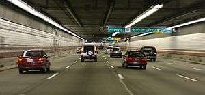
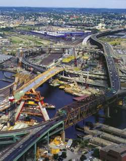
The original Artery, constructed in the 1950s, was named after John F. Fitzgerald; it was partly-elevated and partly-tunneled. Its disruption of previously-interrupted travel within the city inspired the local nicknames "The Distressway," "the largest parking lot in the world," and "the other Green Monster" (referencing Fenway Park and the paint color of the highway girders.)[2] The Artery was majorly rerouted during a 10-year period from the mid-1990s through the early 2000s as part of the Central Artery/Tunnel Project, more widely called the Big Dig. The present-day Artery is almost entirely directed through the newly-constructed O'Neill Tunnel, while the original Artery was demolished and replaced with the Rose Fitzgerald Kennedy Greenway, named after the daughter of John F. Fitzgerald and the mother of John F. Kennedy.
According to Massachusetts Executive Office of Transportation data, the Central Artery runs from the Massachusetts Avenue Connector just beyond Andrew Square in South Boston north to the split with U.S. Route 1 in Charlestown.[3] Along with the harbor tunnels and the Turnpike from Route 128 to East Boston, it is part of the Metropolitan Highway System.
History


The highway itself was planned as early as the 1920s. The above-ground Artery was built in two sections. First was the part north of High Street and Broad Street, to the Tobin Bridge built between 1951 and 1954.[4] Immediately, residents began to hate the new highway and the way it towered over and separated neighborhoods. Due to this opposition, the southern end of the Central Artery through the South Station area was built underground, through what became known as the Dewey Square Tunnel. Eventually, the entire highway was moved underground as part of the Big Dig Project. The Dewey Square Tunnel was the one part of the original Artery not torn down; it now serves southbound traffic. The idea of building the entire Artery underground was first floated in the 1970s emanating from the central artery depression concept developed by the Boston Transportation Planning Review. The final section through the Dewey Square Tunnel and on to the Southeast Expressway at Massachusetts Avenue opened in 1959.
The highway gradually became more and more congested as other highway projects meant to complement the Artery were canceled. These included the Inner Belt project, which would have taken through traffic off the Artery and the Massachusetts Turnpike Extension coming in from the west. The Southwest Expressway would have been the route of Interstate 95 from Canton into Boston, and would have tied into the Inner Belt of I-695.
Modifications of the above-ground Artery until the time it was demolished in 2003, included an additional interchange for the Massachusetts Turnpike (Mass Pike) extension which was completed in 1965, the removal of several on and off-ramps and the reworking in the late 1980s of the Tobin Bridge interchange. The Central Artery North Area (CANA) project placed the above ground ramps from the Artery underground into the City Square Tunnel in Charlestown and resulted in a reworking of the interchange at the north end, placing the northbound offramp from the east side to the west side, and eliminating dangerous weaving across the lanes of the Charlestown High Bridge which required traffic coming from Storrow Drive and wanting to go to Charlestown to cross three lanes of traffic in only a tenth of a mile.
Exit lists
The original Central Artery did not have any exit numbers. These were added after I-93 was placed onto the roadway in 1974. Many of these exits either do not exist or no longer resemble their original forms. Exits 19, 21, and 25 were completely eliminated. 20 and 26 were separated northbound and southbound; 20 northbound uses the old exit 19 location in South Bay, while southbound begins at the portal to the renovated Dewey Square Tunnel (now completely enclosed by Big Dig construction; 26 northbound begins just shy of the tunnel exit onto the Zakim Bridge, while 26 southbound is located in Charlestown's Sullivan Square near northbound exit 28 at the portal to the double decked section of I-93 and feeds onto the Leverett Circle Connector bridge. 22 continued to exist as an offramp to Chinatown from the southbound (former northbound) Dewey Square tunnel until the ramp was closed off in 2004. 23 exists both northbound and southbound and leads to the Scollay Square area. 24 now exits to Haymarket Square and MA-1A (the Callahan Tunnel). Much of the reconfiguration of on and offramps (particularly the wide separations of the ramps for exits 20 and 26) was done to move exiting traffic off the mainline of the road, reducing stress on the mainline.
Pre-Big Dig
The entire route was in Boston, Suffolk County.
| mi | km | Exit | Destinations | Notes | |
|---|---|---|---|---|---|
| 18 | Massachusetts Avenue / Roxbury / Andrew Square / South Bay Center | Southbound exit and northbound left entrance | |||
| 19 | East Berkeley Street / Broadway Albany Street / East Berkeley Street | East Berkeley Street was Dover Street; signed for Broadway northbound and Albany Street southbound | |||
| 20 | Northbound and southbound entrances; before I-90 was built, the northbound exit was for Kneeland Street only, and southbound was for Albany Street/Broadway | ||||
| 21 | Kneeland Street – Chinatown | ||||
| 22 | South Station | No northbound exit | |||
| 23 | Atlantic Avenue / Northern Avenue / High Street / State Street | Southbound signed for High and Congress streets only | |||
| — | Dock Square / Clinton Street | Southbound exit and northbound entrance | |||
| 24 | |||||
| 25 | Causeway Street / North Station Haymarket Square / Government Center | No northbound entrance; signed for Causeway Street northbound and Haymarket Square southbound | |||
| 26 | Storrow Drive / North Station | Northbound left entrance; signed southbound for Storrow Drive only | |||
| Charlestown High Bridge over the Charles River | |||||
| 27 | Northbound left exit, formerly a right exit until around 1990; southbound entrance was on the left until around 1990 | ||||
1.000 mi = 1.609 km; 1.000 km = 0.621 mi
| |||||
Post-Big Dig
The entire route is in Boston, Suffolk County.
| mi | km | Old exit | New exit | Destinations | Notes |
|---|---|---|---|---|---|
| 15.340 | 24.687 | 20 | Northbound exit and southbound entrance; Exits 24A/C on I-90 | ||
| South end of the Thomas P. O'Neill Jr. Tunnel | |||||
| 17.253 | 27.766 | 22 | 20A | South Station | Southbound exit and northbound left entrance; Exit 24C on I-90 |
| 20B | Southbound exit and northbound entrance; Exit 24B on I-90 | ||||
| 16.694 | 26.866 | 22 | Surface Road – Chinatown | Southbound entrance only | |
| 17.340 | 27.906 | 23 | Government Center | Northbound exit and southbound entrance | |
| 17.487 | 28.143 | 23 | Purchase Street | Southbound exit and entrance only | |
| 17.874 | 28.765 | 24A | Government Center | Southbound exit only | |
| 24B | Southbound exit and northbound entrance | ||||
| North end of the Thomas P. O'Neill Jr. Tunnel Leonard P. Zakim Bunker Hill Memorial Bridge over the Charles River | |||||
| 17.892– 19.585 | 28.794– 31.519 | 26 | Leverett Connector; signed as Storrow Drive northbound; northern terminus of concurrency with Route 3 | ||
| 18.603 | 29.939 | 27 | Northbound left exit and southbound entrance; northern terminus of concurrency with US 1 | ||
1.000 mi = 1.609 km; 1.000 km = 0.621 mi
| |||||
Numbering
Currently, the Artery is numbered I-93 and US 1 on the whole route, and Route 3 on all but the northernmost section–it leaves at Exit 26.
The Artery has had many different route numbers through its history. When first built, the section between the Sumner Tunnel and Storrow Drive received the numbers C1 and C9 (city routes of US 1 and Route 9), which were rerouted off local streets. The rest of the highway was unnumbered, despite being closely paralleled by C37 south from the Sumner Tunnel.
By 1969, I-95 was assigned to the whole Artery as part of its never-built route through Boston. The C routes were removed in 1971, with Route C1 becoming part of a realigned US 1, using the Artery between Storrow Drive and the Sumner Tunnel. Additionally in 1971, Route 3 was moved from a bypass around downtown to use the Artery south of Storrow Drive and the Southeast Expressway.
In 1974, I-95 was canceled through Boston and rerouted around the city using part of Route 128. US 1 was realigned to use the Tobin Bridge and Northeast Expressway, which had been signed as part of I-95; thus US 1 used the Artery north of Storrow Drive. The former alignment of US 1 from Storrow Drive south along the Artery to the Sumner Tunnel became an extended 1A, and I-93 was extended south from Charlestown along the Artery, Southeast Expressway and Route 128 from Braintree to Canton. In 1989, US 1 was moved off the MDC Parkways onto its current alignment along the full Artery. Route 1A was then truncated to the Sumner Tunnel interchange.
Signs put up for the new underground Artery only mention I-93, since it is the best-known designation. Older signs may mention only I-93 and US 1 or I-93 and Route 3. A winter 2008/2009 project to update this signage helped to clear up this potentially confusing situation.
See also
-
 U.S. Roads portal
 -
 Massachusetts portal
 -
 Boston portal
Notes
- ↑ Office of Transportation Planning Roads (June 2008). "MassGIS". Executive Office of Transportation.
- ↑ "Boston's Big Dig finally opens to public". MSNBC. Associated Press. December 20, 2003. Retrieved November 13, 2008.
- ↑ Office of Transportation Planning (2007). "Road Inventory". Executive Office of Transportation.
- ↑ "John F. Fitgerald Expressway". The Roads of Metro Boston. Self-published.
- ↑ Google Maps (October 2013). "Street View". Google. Retrieved August 23, 2014.
- ↑ Google Maps (September 2013). "Street View". Google. Retrieved August 23, 2014.
References
| Wikimedia Commons has media related to John F. Fitzgerald Expressway. |