Central, Cleveland
| Central | |
|---|---|
| Neighborhoods of Cleveland | |
|
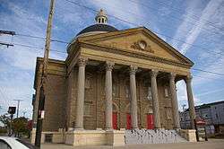
Originally built as the Temple B'nai Jeshurun synagogue in 1905, Shiloh Baptist Church at E.55th and Scovill Avenue is one of several listings in the Central neighborhood on the National Register of Historic Places. | |
| Country | United States |
| State | Ohio |
| County | Cuyahoga County |
| City | Cleveland |
| Population (2000) | |
| • Total | 12,107 |
| 12.2% decrease from 1990 Census | |
| Demographics | |
| • White | >5% |
| • Black | 92.3% |
| • Hispanic | 1.2% |
| • Asian | >1% |
| • Other | >1% |
| Time zone | EST (UTC-5) |
| • Summer (DST) | EDT (UTC-4) |
| ZIP Codes | 44104, 44115 |
| Area code(s) | 216 |
| Median income | $8,657 |
| Source: 2000 U.S. Census, City Planning Commission of Cleveland[1] | |
Central is a neighborhood on the east side of Cleveland, Ohio. Situated on the outskirts of downtown, Central is bounded roughly by East 71st Street on its east and East 22nd Street on its west, with Euclid Avenue and Woodland Avenue on its north and south respectively. The neighborhood is eponymously named for its onetime main thoroughfare, Central Avenue.[2] With settlement beginning during the city's infancy in the early 19th century, Central is of Cleveland's oldest neighborhoods. An influx of Germans in the 1830s marked the first in several waves of immigration to what would be gateway community for many ethnic groups in the Cleveland area.[2] The largest pre-World War I populations of Jews, Italians and African Americans living in Cleveland lived in Central, as well as communities of Czechs and Hungarians. The neighborhood population peaked at a Post-World War II number exceeding 69,000.[1][2] Today, Central has less than one-fifth of its 1950 population, and is demographically a largely homogeneous poverty-stricken, African-American neighborhood.[1]
The neighborhood features several schools including East Technical High School.
History
| Historical population | ||
|---|---|---|
| Year | Pop. | ±% |
| 1940 | 62,038 | — |
| 1950 | 69,665 | +12.3% |
| 1960 | 52,675 | −24.4% |
| 1970 | 27,280 | −48.2% |
| 1980 | 19,363 | −29.0% |
| 1990 | 13,788 | −28.8% |
| 2000 | 12,107 | −12.2% |
| 2010 | 12,378 | +2.2% |
| Source:[3][4] | ||
Central, until just after World War II was arguably the retail capital in the city of Cleveland.[2] The neighborhood remained generally poor to working class and predominately ethnic European until the beginning of World War I, when an exodus of ethnic whites, particularly Jews (many of whom relocated further east to the Glenville neighborhood). The gradual demographic shift saw Central become a commercial district that hired large numbers of African Americans, a revolutionary idea at the time.[2] Between 1910 and 1920, the African American population of Cleveland increased by 400% to 34,451, the majority settling in Central.[2]
Public housing
The onset of the Great Depression was the impetus for a trend that began in Central in the 1930s, and continued through the early 1990s.[5] With the advent of the Public Works Administration, the State of Ohio preceded the federal body established in the National Housing Act of 1934 by creating the nation's first public housing administration in 1933: the Cleveland Metropolitan Housing Authority (CMHA).[5][6] Central would become the location for Cleveland's largest concentration of public housing projects, which was a significant catalyst in the economic decline of the neighborhood.[5] The CMHA began with the Outhwaite Homes, and the Cedar-Central projects in the 1930s. By the 1970s, the additions of Carver Park (1942) and the King-Kennedy high rises (1971) had made Central the public housing capital of Cleveland.[7][8]
Famous residents
- Langston Hughes - Author and playwright, attended Central High School.
- Frank G. Jackson - 56th Mayor of Cleveland (2005–present), currently lives in the Central Neighborhood.
- Carl Stokes - 51st Mayor of Cleveland (1968–1971), first African American elected mayor of a major US City, grew up in the CMHA Outhwaite Homes.
- Louis Stokes - 15-Term US Congressman (1969–1999), brother of Carl, also grew up in the Outwaite Homes.
See also
References
- 1 2 3 "2000 U.S. Census, City Planning Commission of Cleveland" (PDF). Retrieved 2011-07-14.
- 1 2 3 4 5 6 "Central (Neighborhood)". Encyclopedia of Cleveland History. Retrieved 2011-07-14.
- ↑ planning.city.cleveland.oh.us/2010census/downloads/2010SPA_Data.pdf
- ↑ planning.city.cleveland.oh.us/census/factsheets/spa19.pdf
- 1 2 3 "Cuyahoga Metropolitan Housing Authority". Encyclopedia of Cleveland History. Retrieved 2011-07-14.
- ↑ "History". CMHA. Retrieved 2012-11-08.
- ↑ http://www.cmha.net/hopevi/phoenixvillage.aspx
- ↑ http://www.cmha.net/hopevi/carverpark.aspx
External links
 Media related to Central, Cleveland at Wikimedia Commons
 |
Downtown Cleveland | Goodrich-Kirtland Park | Hough, Cleveland | |
| |
Fairfax | |||
| ||||
| | ||||
| Industrial Valley | North Broadway | Kinsman |
Coordinates: 41°30′N 81°40′W / 41.500°N 81.667°W