Celestial coordinate system
|
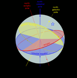
A star's galactic (yellow), ecliptic (red) and equatorial (blue) coordinates, as projected on the celestial sphere. Ecliptic and equatorial coordinates share the vernal equinox (magenta) as the primary direction, and galactic coordinates are referred to the galactic center (yellow). The origin of coordinates (the "center of the sphere") is ambiguous; see celestial sphere for more information. |
In astronomy, a celestial coordinate system is a system for specifying positions of celestial objects: satellites, planets, stars, galaxies, and so on. Coordinate systems can specify a position in 3-dimensional space, or merely the direction of the object on the celestial sphere, if its distance is not known or not important.
The coordinate systems are implemented in either spherical coordinates or rectangular coordinates. Spherical coordinates, projected on the celestial sphere, are analogous to the geographic coordinate system used on the surface of the Earth. These differ in their choice of fundamental plane, which divides the celestial sphere into two equal hemispheres along a great circle. Rectangular coordinates, in appropriate units, are simply the cartesian equivalent of the spherical coordinates, with the same fundamental (x, y) plane and primary (x-axis) direction. Each coordinate system is named after its choice of fundamental plane.
Coordinate systems
The following table lists the common coordinate systems in use by the astronomical community. The fundamental plane divides the celestial sphere into two equal hemispheres and defines the baseline for the latitudinal coordinates, similar to the equator in the geographic coordinate system. The poles are located at ±90° from the fundamental plane. The primary direction is the starting point of the longitudinal coordinates. The origin is the zero distance point, the "center of the celestial sphere", although the definition of celestial sphere is ambiguous about the definition of its center point.
| Coordinate system [1] | Center point (Origin) | Fundamental plane (0° latitude) | Poles | Coordinates | Primary direction (0° longitude) | |
|---|---|---|---|---|---|---|
| Latitude | Longitude | |||||
| Horizontal (also called Alt-Az or El-Az) | observer | horizon | zenith / nadir | altitude (a) or elevation | azimuth (A) | north or south point of horizon |
| Equatorial | center of the Earth (geocentric) / center of the Sun (heliocentric) | celestial equator | celestial poles | declination (δ) | right ascension (α) or hour angle (h) | vernal equinox |
| Ecliptic | ecliptic | ecliptic poles | ecliptic latitude (β) | ecliptic longitude (λ) | ||
| Galactic | center of the Sun | galactic plane | galactic poles | galactic latitude (b) | galactic longitude (l) | galactic center |
| Supergalactic | supergalactic plane | supergalactic poles | supergalactic latitude (SGB) | supergalactic longitude (SGL) | intersection of supergalactic plane and galactic plane | |
Horizontal system
The horizontal, or altitude-azimuth, system is based on the position of the observer on Earth, which revolves around its own axis once per sidereal day (23 hours, 56 minutes and 4.091 seconds) in relation to the "fixed" star background. The positioning of a celestial object by the horizontal system varies with time, but is a useful coordinate system for locating and tracking objects for observers on Earth. It is based on the position of stars relative to an observer's ideal horizon.
Equatorial system
The equatorial coordinate system is centered at Earth's center, but fixed relative to distant stars and galaxies. The coordinates are based on the location of stars relative to Earth's equator if it were projected out to an infinite distance. The equatorial describes the sky as seen from the solar system, and modern star maps almost exclusively use equatorial coordinates.
The equatorial system is the normal coordinate system for most professional and many amateur astronomers having an equatorial mount that follows the movement of the sky during the night. Celestial objects are found by adjusting the telescope's or other instrument's scales so that they match the equatorial coordinates of the selected object to observe.
Popular choices of pole and equator are the older B1950 and the modern J2000 systems, but a pole and equator "of date" can also be used, meaning one appropriate to the date under consideration, such as when a measurement of the position of a planet or spacecraft is made. There are also subdivisions into "mean of date" coordinates, which average out or ignore nutation, and "true of date," which include nutation.
Ecliptic system
The fundamental plane is the plane of the Earth's orbit, called the ecliptic plane. There are two principal variants of the ecliptic coordinate system: geocentric ecliptic coordinates centered on the Earth and heliocentric ecliptic coordinates centered on the center of mass of the solar system.
The geocentric ecliptic system was the principal coordinate system for ancient astronomy and is still useful for computing the apparent motions of the Sun, Moon, and planets.[2]
The heliocentric ecliptic system describes the planets' orbital movement around the Sun, and centers on the barycenter of the solar system (i.e. very close to the center of the Sun). The system is primarily used for computing the positions of planets and other solar system bodies, as well as defining their orbital elements.
Galactic system
The galactic coordinate system uses the approximate plane of our galaxy as its fundamental plane. The solar system is still the center of the coordinate system, and the zero point is defined as the direction towards the galactic center. Galactic latitude resembles the elevation above the galactic plane and galactic longitude determines direction relative to the center of the galaxy.
Supergalactic system
The supergalactic coordinate system corresponds to a fundamental plane that contains a higher than average number of local galaxies in the sky as seen from Earth.
Converting coordinates
Conversions between the various coordinate systems are given.[3] See the notes before using these equations.
Notation
- Horizontal coordinates
- Equatorial coordinates
- α – right ascension
- δ – declination
- h – hour angle
- Ecliptic coordinates
- λ – ecliptic longitude
- β – ecliptic latitude
- Galactic coordinates
- l – galactic longitude
- b – galactic latitude
- Miscellaneous
- λo – observer's longitude
- φo – observer's latitude
- ε – obliquity of the ecliptic
- θL – local sidereal time
- θG – Greenwich sidereal time
Hour angle ↔ right ascension


Equatorial ↔ ecliptic
The classical equations, derived from spherical trigonometry, for the longitudinal coordinate are presented to the right of a bracket; simply dividing the first equation by the second gives the convenient tangent equation seen on the left.[4] The rotation matrix equivalent is given beneath each case.[5] This division is ambiguous because tan has a period of 180° (π) whereas cos and sin have periods of 360° (2π).

- .


Equatorial ↔ horizontal
Note that azimuth (A) is measured from the south point, turning positive to the west.[6] Zenith distance, the angular distance along the great circle from the zenith to a celestial object, is simply the complementary angle of the altitude: 90° − a.[7]


Equatorial ↔ galactic
These equations are for converting equatorial coordinates referred to B1950.0. If the equatorial coordinates are referred to another equinox, they must be precessed to their place at B1950.0 before applying these formulae.


These equations convert to equatorial coordinates referred to B1950.0.


Notes on conversion
- Angles in the degrees ( ° ), minutes ( ′ ), and seconds ( ″ ) of sexagesimal measure must be converted to decimal before calculations are performed. Whether they are converted to decimal degrees or radians depends upon the particular calculating machine or program. Negative angles must be carefully handled; –10° 20′ 30″ must be converted as −10° −20′ −30″.
- Angles in the hours ( h ), minutes ( m ), and seconds ( s ) of time measure must be converted to decimal degrees or radians before calculations are performed. 1h = 15°; 1m = 15′; 1s = 15″
- Angles greater than 360° (2π) or less than 0° may need to be reduced to the range 0°−360° (0−2π) depending upon the particular calculating machine or program.
- Inverse trigonometric functions arcsine, arccosine and arctangent are quadrant-ambiguous, and results should be carefully evaluated. Use of an equation which finds the tangent, followed by the second arctangent function (ATN2 or ATAN2), is recommended when calculating longitude/right ascension/azimuth. An equation which finds the sine, followed by the arcsin function, is recommended when calculating latitude/declination/altitude.
- Azimuth (A) is referred here to the south point of the horizon, the common astronomical reckoning. An object on the meridian to the south of the observer has A = h = 0° with this usage. In navigation and some other disciplines, azimuth is figured from the north.
- The equations for altitude (a) do not account for atmospheric refraction.
- The equations for horizontal coordinates do not account for diurnal parallax, that is, the small offset in the position of a celestial object caused by the position of the observer on the Earth's surface. This effect is significant for the Moon, less so for the planets, minute for stars or more distant objects.
- Observer's longitude (λo) here is measured positively westward from the prime meridian; this is contrary to current IAU standards.
See also
- Azimuth
- Celestial sphere
- International Celestial Reference System
- Orbital elements
- Spherical coordinate system
Notes and references
- ↑ Majewski, Steve. "Coordinate Systems". UVa Department of Astronomy. Retrieved 19 March 2011.
- ↑ Aaboe, Asger. 2001 Episodes from the Early History of Astronomy. New York: Springer-Verlag., pp. 17–19.
- ↑ Meeus, Jean (1991). Astronomical Algorithms. Willmann-Bell, Inc., Richmond, VA. ISBN 0-943396-35-2., chap. 12
- ↑ U.S. Naval Observatory, Nautical Almanac Office; H.M. Nautical Almanac Office (1961). Explanatory Supplement to the Astronomical Ephemeris and the American Ephemeris and Nautical Almanac. H.M. Stationery Office, London., sec. 2A
- ↑ U.S. Naval Observatory, Nautical Almanac Office (1992). P. Kenneth Seidelmann, ed. Explanatory Supplement to the Astronomical Almanac. University Science Books, Mill Valley, CA. ISBN 0-935702-68-7., section 11.43
- ↑ Montenbruck, Oliver; Pfleger, Thomas (2000). Astronomy on the Personal Computer. Springer-Verlag Berlin Heidelberg. ISBN 978-3-540-67221-0.,pp 35-37
- ↑ U.S. Naval Observatory, Nautical Almanac Office; U.K. Hydrographic Office, H.M. Nautical Almanac Office (2008). The Astronomical Almanac for the Year 2010. U.S. Govt. Printing Office. p. M18. ISBN 978-0160820083.
- ↑ Depending on the azimuth convention in use, the signs of cos A and sin A appear in all four different combinations. Karttunen et al., Taff and Roth define A clockwise from the south. Lang defines it north through east, Smart north through west. Meeus (1991), p. 89: sin δ = sin φ sin a − cos φ cos a cos A; Explanatory Supplement (1961), p. 26: sin δ = sin a sin φ + cos a cos A cos φ.
- Smart, William Marshall (1949). Text-book on spherical astronomy. Cambridge University Press. Bibcode:1965tbsa.book.....S.
- Lang, Kenneth R. (1978). Astrophysical Formulae. Springer. Bibcode:1978afcp.book.....L. ISBN 3-540-09064-9.
- Taff, L. G. (1980). Computational spherical astronomy. Wiley. Bibcode:1981csa..book.....T.
- Karttunen, H.; Kröger, P.; Oja, H.; Poutanen, M.; Donner, H. J. (2006). Fundamental Astronomy. Bibcode:2003fuas.book.....K. ISBN 978-3-540-34143-7.
- Roth, G. D. Handbuch für Sternenfreunde. Springer. ISBN 3-540-19436-3.
External links
| Wikimedia Commons has media related to Celestial coordinate systems. |
- NOVAS, the U.S. Naval Observatory's Vector Astrometry Software, an integrated package of subroutines and functions for computing various commonly needed quantities in positional astronomy.
- SOFA, the IAU's Standards of Fundamental Astronomy, an accessible and authoritative set of algorithms and procedures that implement standard models used in fundamental astronomy.
- This article was originally based on Jason Harris' Astroinfo, which comes along with KStars, a KDE Desktop Planetarium for Linux/KDE.