Cavalla River
"Youbou" redirects here. For the small town in western Canada, see Youbou, British Columbia.
| Cavalla river | |
|---|---|
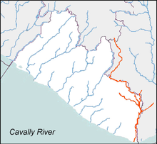 The Cavalla River drains the border areas of Côte d'Ivoire and Liberia. | |
| Other name(s) | Cavally, Youbou, Diougou |
| Country | Guinea, Côte d'Ivoire, and Liberia |
| Basin | |
| River mouth |
Gulf of Guinea 0 m (0 ft) |
| Physical characteristics | |
| Length | 515 km (320 mi) |
The Cavalla River (also known as the Cavally, the Youbou and the Diougou) is a river in West Africa running from north of Mont Nimba in Guinea, through Côte d'Ivoire, to Zwedru in Liberia, and back to the border with Côte d'Ivoire. It ends in the Gulf of Guinea 21 km (13 mi) east of Harper, Liberia. It forms the southern two-thirds of the international boundary between Liberia and Côte d'Ivoire.
It has a length of 515 kilometers (320 mi), and is the longest river in Liberia.[1] The name is derived from the cavalla horse mackerel found at its mouth.[2]
References
- ↑ Bateman, Graham; Victoria Egan; Fiona Gold; Philip Gardner (2000). Encyclopedia of World Geography. New York: Barnes & Noble Books. p. 161. ISBN 1-56619-291-9.
- ↑ Cavalla River at Encyclopædia Britannica
External links
Coordinates: 4°22′N 7°32′W / 4.367°N 7.533°W
This article is issued from Wikipedia - version of the 5/6/2016. The text is available under the Creative Commons Attribution/Share Alike but additional terms may apply for the media files.