Catatumbo lightning

Catatumbo lightning (Spanish: Relámpago del Catatumbo)[1] is an atmospheric phenomenon in Venezuela. It occurs only over the mouth of the Catatumbo River where it empties into Lake Maracaibo.
It originates from a mass of storm clouds at a height of more than 1 km, and occurs during 140 to 260 nights a year, 10 hours per day and up to 280 times per hour. It occurs over and around Lake Maracaibo, typically over the bog area formed where the Catatumbo River flows into the lake.[2]
Catatumbo Lightning changes its frequency along the year, and it is different from year to year. For example, it ceased from January to March 2010, apparently due to drought, temporarily raising fears that it might have been extinguished permanently.[3][4][5]
Historical references
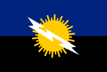

Some authors have misunderstood an early reference to the lightnings in Lope de Vega's description in his epic La Dragontea of an incident during the attack against San Juan de Puerto Rico by the English corsary Francis Drake. [6] The Prussian naturalist and explorer Alexander von Humboldt once described it. [7] Italian geographer Agustin Codazzi described it: "like a continous lightning, and its position such that, located almost on the meridian of the mouth of the lake, it directs the navigators as a lighthouse."[8] The phenomenon became so celebrated that it was depicted in the flag and coat of arms of the state of Zulia, which contains Lake Maracaibo, and mentioned in the state's anthem. This phenomenon has been popularly known for centuries as the Lighthouse of Maracaibo, since it is visible for miles around Lake Maracaibo.[9]
Location and mechanism
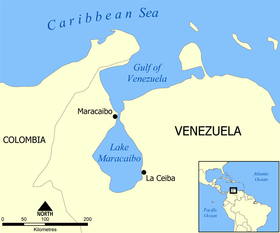
Catatumbo lightning usually develops between the coordinates 8°30′N 71°0′W / 8.500°N 71.000°W and 9°45′N 73°0′W / 9.750°N 73.000°W. The storms (and associated lightning) are likely the result of the winds blowing across the Maracaibo Lake and surrounding swampy plains. These air masses inevitably meet the high mountain ridges of the Andes, the Perijá Mountains (3,750 m), and Mérida's Cordillera, enclosing the plain from three sides. The heat and moisture collected across the plains creates electrical charges and, as the air masses are destabilized by the mountain ridges, result in thunderstorm activity.[3] The phenomenon is characterized by almost continuous lightning, mostly within the clouds, which is produced in a large vertical development of clouds.
The lightnings produce a great quantity of ozone though its instability makes it dubious that it has any effect on the ozonosphere.[10]
Previous studies
Among the major modern studies there is the one done by Melchor Centeno, who attributes the origin of the thunderstorms to closed wind circulation in the region. Between 1966 and 1970, Andrew Zavrostky investigated the area three times, with assistance from the University of the Andes. He concluded that the lightning has several epicenters in the marshes of Juan Manuel de Aguas National Park, Claras Aguas Negras, and west Lake Maracaibo. In 1991 he suggested that the phenomenon occurred due to cold and warm air currents meeting around the area. The study also speculated that an isolated cause for the lightning might be the presence of uranium in the bedrock.[11]
Between 1997 and 2000 Nelson Falcón and collaborators conducted four studies, and proposed a microphysics model of Catatumbo lightning. He identified the methane produced by the swamps and the oil deposits in the area as a major cause of the phenomenon.[12] The methane model is based on symmetry properties of the methane. Different studies[13][14] have indicated that this model does not agree with the observed behaviour of Catatumbo lightning, as - for example - it indicates that there must be more lightning in the dry season (January–February), and less in the wet season (April–May and September–October).
A team from the Center for Scientific Modeling at Universidad del Zulia, coordinated by Ángel G. Muñoz, has investigated the impact of different atmospheric variables on Catatumbo lightning's daily, seasonal and year-to-year variability,[15] finding relationships with the Inter-Tropical Convergence Zone, ENSO, the Caribbean Low-Level Jet,[16] and the local winds and convective available potential energy.[17][18]
Using satellite data, two groups of researchers led by Rachel Albrecht[19][20] and Ricardo Bürgesser[13] have provided detailed analysis about Catatumbo lightning's location, timing and number of discharges per square kilometer (density).
Predictability

A more recent study[21] has shown that it is possible to forecast lightning in the Lake Maracaibo basin up to a few months in advance, based in the variability of the Lake Maracaibo Low-Level Jet and its interactions with predictable climate modes like ENSO and the Caribbean Low-Level Jet. The study also shows that the forecast skill is significantly higher when an index based on a combination of winds and convective available potential energy is used. The index seems to capture well the compound effect of multiple climate drivers.
In order to calibrate physical and statistical models to make their forecasts, the team has been acquiring data with tethered balloons and micro-weather stations tied to the balloon's line.
References
- ↑ "Fogonazos: Catatumbo, the everlasting storm". Fogonazos.blogspot.com. Retrieved 2010-07-27.
- ↑ "Catatumbo Lightning – Congo". Real Travel. Archived from the original on 2011-07-16. Retrieved 2010-07-27.
- 1 2 "Catatumbo Lightning". Wondermondo.
- ↑ Carroll, Rory (5 March 2010). "Drought extinguishes Venezuela's lightning phenomenon". The Guardian. Retrieved 3 January 2013.
- ↑ Guttman, Matt; Robert Rudman. "Venezuela's Mysterious Catatumbo Lightning Phenomenon Vanishes for Months, Then Reappears". ABC News. Retrieved 3 January 2013.
- ↑ Dislates y Disparates sobre el Relámpago del Catatumbo: La expedición de Drake, de 1595, Ángel Vicente Muñoz García, Centro de Modelado Científico, Maracaibo, agosto 2016.
- ↑ La distancia de más de 40 leguas a que se distingue la luz ha hecho creer que podría ser el efecto de una tempestad o de explosiones eléctricas que tuviesen lugar diariamente en una garganta de montañas y aun se asegura que se oye el ruido del trueno cuando se aproxima uno al farol.
- Alexander von Humboldt and Aimé Bonpland, Viage a las Regiones Equinocciales del Nuevo Continente, volume 2, book V, chapter XVI, page 390, note, Casa de Rosa, Paris, 1826; Ediciones del Ministerio de Educación, 2a. ed., Caracas, 1956.
- ↑ Es como un relámpago continuado y su posición tal que, situado casi en el meridiano de la boca del lago de Maracaibo, dirige a los navegantes como un faro.
- Codazzi Agustín, Resumen de la Geografía de Venezuela, Fournier, Paris, 1841, pp. 20, 464 y 466.
- ↑ "Lightning Up, 4 Feb 2010". Blogs.ngm.com. 2002-10-17. doi:10.1371/journal.pbio.0040050. Retrieved 2013-02-08.
- ↑ ¿Relámpagos del Catatumbo regeneran la capa de ozono?. Agencia de noticias de la Universidad del Zulia.
- ↑ "Una vida consagrada a los números" (PDF).
- ↑ "Phenomena – A science salon hosted by National Geographic Magazine". Blogs.ngm.com. 2002-10-17. doi:10.1371/journal.pbio.0040050. Retrieved 2013-02-08.
- 1 2 Bürgesser, R. E.; Nicora, M. G.; Ávila, E. E. (2012). "Characterization of the lightning activity of "Relámpago del Catatumbo". Journal of Atmospheric and Solar-Terrestrial Physics. 77: 241–247. doi:10.1016/j.jastp.2012.01.013.
- ↑ Muñoz, Á.G.; Díaz-Lobatón, J.; Chourio, X.; Stock, J. (2016). "Seasonal prediction of lightning activity in North Western Venezuela: Large-scale versus local drivers". Atmospheric Research. 172–173: 147–162. doi:10.1016/j.atmosres.2015.12.018.
- ↑ Muñoz, Á.G., Díaz-Lobatón, J., 2011: "The Catatumbo Lightnings: A review", Memoirs of the XIV International Conference on Atmospheric Electricity. Brazil.
- ↑ Torrealba, E.; Amador, J. (2010). "La corriente en chorro de bajo nivel sobre los Llanos Venezolanos de Sur América". Revista de Climatología. 10: 1–20.
- ↑ Muñoz, Á.G., Díaz-Lobatón, J., 2012: Los Relámpagos del Catatumbo y el Flujo Energético Medio en la Cuenca del Lago de Maracaibo. Reporte público CMC-GEO-DDI-02-2011. Centro de Modelado Científico. Universidad del Zulia. 12 p. En http://cmc.org.ve/portal/archivo.php?archivo=241
- ↑ Muñoz, Á.G., Núñez, A., Chourio, X., Díaz-Lobatón, J., Márquez, R., Moretto, P., Juárez, M., Casanova, V., Quintero, A., Zurita, D., Colmenares, V., Vargas, L., Salcedo, M.L., Padrón, R., Contreras, L., Parra, H., Vaughan, C., Smith, D., 2015: Reporte Final de la Expedición Catatumbo: Abril 2015. Reporte Público CMC-01-2015. Centro de Modelado Científico (CMC). Universidad del Zulia. 20 p. doi:10.13140/RG.2.1.1351.0566
- ↑ Albrecht, R., et al., 2011. The 13 years of TRMM Lightning Imaging Sensor: from individual flash characteristics to decadal tendencies. XIV Int. Conf. Atmos. Elec., Rio de Janeiro, Brazil.
- ↑ Albrecht, R. I.; Goodman, S. J.; Buechler, D. E.; Blakeslee, R. J.; Christian, H. J.; Albrecht, R. I.; Christian, H. J. (2016). "Where are the lightning hotspots on Earth?". Bulletin of the American Meteorological Society. doi:10.1175/BAMS-D-14-00193.1.
- ↑ Muñoz, Á.G.; Díaz-Lobatón, J.; Chourio, X.; Stock, J. (2016). "Seasonal prediction of lightning activity in Northwestern Venezuela: Large-scale versus local drivers". Atmospheric Research. 172–173: 147–162. doi:10.1016/j.atmosres.2015.12.018.
External links
- World's first seasonal lightning forecast
- Storm Chaser George Kourounis Investigates the Catatumbo Lightning Phenomenon
- An Everlasting Lightning Storm, article at Slate.com
- WWLLN World Wide Lightning Location Network
Coordinates: 9°20′39″N 71°42′38″W / 9.34417°N 71.71056°W