Castle Peak (Idaho)
| Castle Peak | |
|---|---|
|
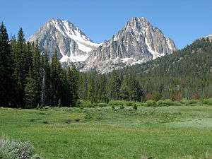
Castle Peak in White Clouds | |
| Highest point | |
| Elevation | 11,815 ft (3,601 m) [1] |
| Prominence | 4,015 ft (1,224 m) [1] |
| Coordinates | 44°02′22″N 114°35′07″W / 44.039558°N 114.585266°WCoordinates: 44°02′22″N 114°35′07″W / 44.039558°N 114.585266°W [1] |
| Geography | |
 Castle Peak | |
| Parent range | White Cloud Mountains |
| Topo map | USGS Boulder Chain Lakes |
| Climbing | |
| Easiest route | Scramble, class 3 |

Castle Peak, at 11,815 feet (3,601 m) above sea level is the highest peak in the White Cloud Mountains of Idaho. Castle Peak is the 25th highest peak in Idaho, and the 9th most prominent peak in the state.[2][3] Castle Peak is located within the White Clouds Wilderness, which is part of Sawtooth National Recreation Area in Custer County. The towns of Stanley, Idaho and Challis, Idaho are both about 21 miles (34 km) from Castle Peak, Ketchum, Idaho is about 27 miles (43 km) from the peak.
Castle Peak is managed by the United States Forest Service and the area surrounding the peak can be easily accessed. Camping is permitted anywhere is Sawtooth National Forest and the lakes surrounding Castle Peak provide excellent places to stay. The peak rises to the northeast of Chamberlain Basin and south of Castle Lake and Merriam Peak.[4] There are trails from parking area to the vicinity of Castle Peak, although no trails go up the peak itself. The easiest route up Castle Peak is as class 3 scramble from the Chamberlain Basin.
-
Castle Peak (left) and Merriam Peak (right)
-

Castle Peak from Sawtooth Mountains
-

Castle Peak
See also
References
- 1 2 3 "Castle Peak, Idaho". Peakbagger.com. Retrieved 2009-09-18.
- ↑ "Idaho 11,000-foot Peaks". Peakbagger.com. Retrieved 2011-05-09.
- ↑ "Idaho Peaks with 2000 feet of Prominence". Peakbagger.com. Retrieved 2011-05-09.
- ↑ Sawtooth National Forest. “Sawtooth National Forest” [map].1:126,720, 1”=2 miles. Twin Falls, Idaho: Sawtooth National Forest, United States Forest Service, 1998.
External links
- "Castle Peak". IdahoSummits.com. Retrieved 2011-05-09.
- "Castle Peak". SummitPost.org. Retrieved 2011-05-09.
- "Castle Peak". Geographic Names Information System. United States Geological Survey. Retrieved 2011-08-08.
- "Sawtooth National Forest". United States Forest Service. Retrieved 2011-05-09.