Castagnole delle Lanze
| Castagnole delle Lanze | ||
|---|---|---|
| Comune | ||
| Comune di Castagnole delle Lanze | ||
| ||
 Castagnole delle Lanze Location of Castagnole delle Lanze in Italy | ||
| Coordinates: 44°45′N 8°9′E / 44.750°N 8.150°ECoordinates: 44°45′N 8°9′E / 44.750°N 8.150°E | ||
| Country | Italy | |
| Region | Piedmont | |
| Province / Metropolitan city | Province of Asti (AT) | |
| Frazioni | Annunziata, Carossi, Farinere, Olmo, Rivella, San Bartolomeo, San Grato, San Defendente, San Rocco, San Pietro, Santa Maria, Valle Tanaro, Val Bera | |
| Area | ||
| • Total | 21.4 km2 (8.3 sq mi) | |
| Population (Dec. 2004) | ||
| • Total | 3,711 | |
| • Density | 170/km2 (450/sq mi) | |
| Demonym(s) | Castagnolesi | |
| Time zone | CET (UTC+1) | |
| • Summer (DST) | CEST (UTC+2) | |
| Postal code | 14054 | |
| Dialing code | 0141 | |
| Website | Official website | |

Castagnole delle Lanze is a comune (municipality) in the Province of Asti in the Italian region Piedmont, located about 50 kilometres (31 mi) southeast of Turin and about 15 kilometres (9 mi) south of Asti. As of 31 December 2004, it had a population of 3,711 and an area of 21.4 square kilometres (8.3 sq mi).[1]
The municipality of Castagnole delle Lanze contains the frazioni (subdivisions, mainly villages and hamlets) Annunziata, Carossi, Farinere, Olmo, Rivella, San Bartolomeo, San Grato, San Defendente, San Rocco, San Pietro, Santa Maria, Valle Tanaro, and Val Bera.
Castagnole delle Lanze borders the following municipalities: Castiglione Tinella, Coazzolo, Costigliole d'Asti, Govone, Magliano Alfieri, and Neive.
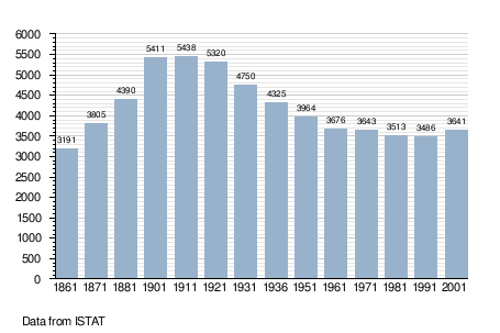
Demographic evolution
Twin towns — Sister cities
Castagnole delle Lanze is twinned with:
-
 Brackenheim, Germany
 -
 Charnay-lès-Mâcon, France
 -
 Zbrosławice, Poland
 -
 Tarnalelesz, Hungary