Casarabonela
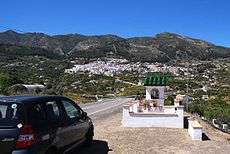
View to Casarabonela
Casarabonela is a town and municipality in the province of Málaga, part of the autonomous community of Andalusia in southern Spain. The municipality is situated approximately 48 km from Malaga capital (bordering on the regions of Antequera and Ronda). It has a population of approximately 2,500 residents. The natives are called Moriscos.
-- Etymology --
The name derives from the Arabic قصر بنيرة - QaSr Bunayra "The Alcazar (Palace) of Bonéra", as attested to by Ibn al-Qūṭiyya.
| Climate data for Casarabonela (elevation: 480m, data from 1967-1981) | |||||||||||||
|---|---|---|---|---|---|---|---|---|---|---|---|---|---|
| Month | Jan | Feb | Mar | Apr | May | Jun | Jul | Aug | Sep | Oct | Nov | Dec | Year |
| Average high °C (°F) | 15.7 (60.3) |
15.2 (59.4) |
16.8 (62.2) |
17.9 (64.2) |
20.9 (69.6) |
25.0 (77) |
29.0 (84.2) |
30.3 (86.5) |
25.0 (77) |
22.2 (72) |
18.2 (64.8) |
15.9 (60.6) |
21.0 (69.8) |
| Daily mean °C (°F) | 11.7 (53.1) |
11.3 (52.3) |
12.4 (54.3) |
13.2 (55.8) |
15.8 (60.4) |
19.4 (66.9) |
23.2 (73.8) |
24.3 (75.7) |
20.0 (68) |
17.5 (63.5) |
14.1 (57.4) |
11.8 (53.2) |
16.2 (61.2) |
| Average low °C (°F) | 7.6 (45.7) |
7.5 (45.5) |
7.9 (46.2) |
8.6 (47.5) |
10.7 (51.3) |
13.7 (56.7) |
17.4 (63.3) |
18.3 (64.9) |
15.1 (59.2) |
12.9 (55.2) |
10.0 (50) |
7.7 (45.9) |
11.5 (52.7) |
| Source: Sistema de Clasificación Bioclimática Mundial[1] | |||||||||||||
Coordinates: 36°47′N 4°51′W / 36.783°N 4.850°W
References
This article is issued from Wikipedia - version of the 12/13/2013. The text is available under the Creative Commons Attribution/Share Alike but additional terms may apply for the media files.