Carta marina
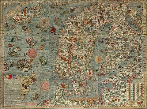
The Carta marina is the common short form of what is more fully titled Carta marina et descriptio septentrionalium terrarum (Latin "Marine map and description of the Northern lands").[1] Swedish ecclesiastic Olaus Magnus created the map, which was published in 1539. This is the earliest map of the Nordic countries that gives details and place names. Only two earlier maps of the Nordic countries are known, those of Jacob Ziegler (Strasbourg, 1532) and Claudius Clavus (15th century).
Description
The map is centered on Scandia, which is shown in the largest size text on the map and placed on the middle of Sweden. The map covers the Nordic lands of "Svecia" (Svealand), "Gothia" (Götaland), "Norvegia" (Norway), Dania (Denmark), Islandia (Iceland) and Finlandia (Finland). The map is framed with longitudes and latitudes running from 55° to the Arctic Circle.[2]
The map was printed in black and white from nine 55x40 cm woodcut blocks to produce a document that is 1.70 m wide by 1.25 m tall. The sheets are sequenced from west to east and north to south and identified in the center with the letters A through I.[3]
History
The map was created in Rome during 1527–39 by Olaus Magnus (1490–1557), who arrived on a diplomatic visit for the Swedish government and stayed on, likely because his brother Johannes Magnus became involved in a religious feud with King Gustav I of Sweden.
The map was in production for 12 years, the first copies were printed in 1539 in Venice.
Olaus complemented the map with Historia de gentibus septentrionalibus ("A description of the Northern peoples") printed in Rome, 1555. These Latin notes were translated by Olaus into Italian (1565) and German (1567).
A colored reproduction of the map was printed in Rome by Antoine Lafréry in 1572.[4]
Surviving Copies
All of the original map's copies passed out of public knowledge after 1574, and the map was largely forgotten – perhaps because few copies were printed and Pope Paul III asserted a 10-year "copyright." It was later widely questioned whether the map had ever existed.[3]
In 1886, Oscar Brenner found a copy at the Hof- und Staatsbibliothek in Munich, where it currently resides. In 1961, another copy was found in Switzerland, brought to Sweden the following year by the Uppsala University Library; as of 2007 it is stored at Carolina Rediviva.[3]
See also
Martin Waldseemüller, who had created an earlier similar map of the world in 1516 with the same title.
Notes
- ↑ "Carta Marina". Olaus Magnus' Scandinavia. University of Minnesota. Retrieved 10 June 2016.
- ↑ Kleim, Uwe (1989). "Ein Kartenwerk der Nordlande vom Jahre 1539". Retrieved 9 June 2016.
- 1 2 3 Kaiser, Reinhard. "Der Anfang - Glücklicher Zufall". Reinhard Kaisers Elektroarchiv (in German). Reinhard Kaiser. Retrieved 10 June 2016.
- ↑ "Carta marina". The University of Minnesota Archives. Retrieved 10 June 2016.
References
- (Swedish)"Geografiens och de geografiska upptäckternas historia / Geography and The Geographical Voyager's history" (1899)
- "Carta marina et descriptio : the commentary by Olaus Magnus to Map of the Scandinavian countries 1539", Provisional ed. (1988)
- "Carta Marina, Lafreris edition 1572"- Antoine Lafréry's (1512 - 1577) edition from 1572, digitalized by the National Library of Sweden in Stockholm
External links
| Wikimedia Commons has media related to Carta marina. |
- CIPHER Project - Exploring the Carta Marina
- Carta Marina (Uppsala University Library)
- "University of Minnesota Carta Marina" - the original or Pope Paul III (1468–1549) map from 1539, in jpeg images. The site contains more information on early printing process.
- Carta Marina, Lafreris edition 1572 at the World Digital Library (Antoine Lafréry's (1512 - 1577) edition from 1572 digitized by the National Library of Sweden in Stockholm
- Drømmen om hjemlandet [The dream about the country of origin]