Carp, Ontario
| Carp | |
|---|---|
| Rural community | |
 | |
 Carp | |
| Coordinates: 45°21′00″N 76°02′00″W / 45.35000°N 76.03333°WCoordinates: 45°21′00″N 76°02′00″W / 45.35000°N 76.03333°W | |
| Country |
|
| Province |
|
| City |
|
| Government | |
| • Mayor | Jim Watson |
| • City Councilor | Eli El-Chantiry |
| • MP | Karen McCrimmon |
| • MPP | Jack MacLaren |
| Elevation | 100 m (300 ft) |
| Population (2011) | |
| • Total | 1,965 |
| Canada 2011 Census | |
| Time zone | Eastern (EST) (UTC−5) |
| • Summer (DST) | EDT (UTC−4) |
| Postal code | K0A 1L0 |
Carp is a compact rural community[1] in West Carleton-March Ward in the City of Ottawa, Ontario, Canada, located in the northwestern portion of the municipality on the Carp River. Prior to amalgamation in 2001, Carp was located in the Township of West Carleton
Carp is located in the Carleton-Mississippi Mills electoral riding.
According to the Canada 2011 Census, 1,965 people lived in the area around Carp (Craig Sideroad/Murphy Sideroad on the north, former Township limits on the east, March Road on the south and Thomas Argue Road on the west)[2]
History
By 1866, Carp was a post village with a population of 200 of the Township of Huntley on the Carp river, 20 miles from Ottawa. The village contained three stores, workshops, three hotels, and a town hall. The Loyal Orange Lodge, No. 439, met at the Orange Hall Carp on the first Wednesday in each month. Citizens included J. W. Featherston, general merchant and postmaster.[3]
The village takes its name from the Carp River which runs through the village. The main street was formerly a section of the Trans-Canada Highway and carried much of the traffic coming from the west into Ottawa. However the village has been bypassed with the development of the Highway 417.
With the amalgamation of municipal governments in the region in 2001, Carp is now governed as part of the new city of Ottawa. Carp is used as a mailing address for most of the former Huntley Township.[4] As such, residents of this large area will identify themselves as living in Carp although they may live large distances from the village proper.
Features and attractions
Carp's main attraction is the Diefenbunker, Canada's Cold War museum located just north of the village, and was featured in the film The Sum of All Fears. This formerly top-secret underground bunker was originally built to house key members of the government in the event of a nuclear attack on Ottawa.[5]
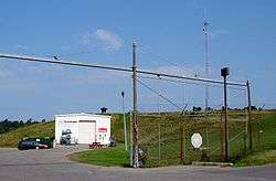
In 1960, NATO and the Canadian Department of National Defence built a satellite communications (SATCOM) station which supports a 68-foot diameter metal space frame radar dome (radome) on its roof, which provides environmental protection for the 50-foot diameter SATCOM antenna it houses. Until 1999 when NATO and DND decommissioned the site, the antenna provided satellite communications between all NATO countries. In 1999, it was purchased by Canadian Space Services Ltd. to serve as its corporate headquarters.[6]
The Carp Exhibit Hall, one of the few remaining octagonal frame fairground buildings in Ontario, continues to function as the main fairground hall for the Carp Fair held in September each year since 1880.[7] During the remainder of the year, the buildings and grounds serve the popular Carp Farmers’ Market held each Saturday from May to October.[8] The red-painted Exhibit Hall with white trim, which remains a focal point in Carp was included amongst other architecturally interesting and historically significant buildings in Doors Open Ottawa, held June 2 and 3, 2012.[9]
The Carleton Masonic Lodge #465, a turn of the Century (1900’s) Church building has been the Masonic Lodge in the Village of Carp since 1925. The building features original stained glass windows and is decorated with beautiful oak furniture that was originally located in a World War I Military Masonic Lodge in France. The original Masonic lodge building, which dates to 1904 was destroyed by fire in 1920.[10]
Carp was the site of an alleged 1989 UFO landing. It has been called "One Of The Most Significant Cases In UFO History."[11] Someone dubbed 'Guardian' filmed the entire UFO crash. The American TV Show Unsolved Mysteries filmed an episode on Guardian in 1993.[12]
There are three schools in the Carp area: Huntley Centennial Public School, St. Michael's (Corkery), and Venta, a private school.
The Carp Airport is located just south of the village.
The Carp River
This Carp river initially took its name due to the overwhelming amount of the carp fish that lived within it. In the early 19th century the river was overrun with the fish because farmers used to throw all of their dead animals in it. Conversely, in "Carleton Saga" by Harry and Olive Walker, the over-abundant fish is said by early French explorers to be suckers and mud-pout, that in French translate as carpe.
References
- ↑ http://www4.rncan.gc.ca/search-place-names/unique/FAPAL
- ↑ Population calculated by combining dissemination areas 35061379 and 35061380 with census blocks 3506138101, 3506138102, 3506138103, 3506138105, 3506138110)
- ↑ Ottawa City and counties of Carleton and Russell Directory, 1866-7
- ↑ https://maps.google.ca/maps?q=K0A+1L0&oe=utf-8&client=firefox-a&ie=UTF-8&ei=cODNUvvoOMGbrgH7y4DADg&ved=0CAoQ_AUoAg
- ↑ http://ottawa.ca/doorsopen Doors Open Ottawa
- ↑ http://ottawa.ca/doorsopen Doors Open Ottawa
- ↑ http://www.carpfair.ca/
- ↑ http://www.carpfarmersmarket.com/
- ↑ http://ottawa.ca/doorsopen Doors Open Ottawa
- ↑ http://ottawa.ca/doorsopen Doors Open Ottawa
- ↑
- ↑
Sources
- Carp Guardian Case retrieved 2007-11-02
- Riding Information retrieved 2012-14-02
External links
| Wikimedia Commons has media related to Carp, Ontario. |
| Wikivoyage has a travel guide for Carp. |
- Huntley Community Association website
- Official website of the annual Carp Fair
- History of Carp at the Farmers' Market website
- Huntley Centennial School Council website
- Website to preserve Carp's historic village character
- Guide to the Village of Carp
 |
Kinburn | Dunrobin | Marchhurst | |
| Marathon | |
Westwood | ||
| ||||
| | ||||
| Corkery | Manion Corners | Huntley |