The Carolinas
| The Carolinas | |
|---|---|
| Region | |
 | |
| Country |
|
| States |
|
| Principal cities |
- Charleston, South Carolina - Charlotte, North Carolina - Columbia, South Carolina - Durham, North Carolina - Greensboro, North Carolina - Greenville, South Carolina - Raleigh, North Carolina - Winston-Salem, North Carolina |
| Colonized as Province of Carolina |
1663 |
| Area | |
| • Total | 85,839 sq mi (222,320 km2) |
| • Land | 78,804 sq mi (204,100 km2) |
| • Water | 7,025 sq mi (18,190 km2) 8.2% |
| Population (2015) | |
| • Total | 14,938,948 |
| • Density | 170/sq mi (67/km2) |
| Demonym(s) | Carolinian |
| Time zone | EST (UTC-5) |
| • Summer (DST) | EDT (UTC-4) |
The Carolinas are the U.S. states of North Carolina and South Carolina, considered collectively. Combining North Carolina's population of 10,042,802 and South Carolina's of 4,896,146, the Carolinas have a population of 14,938,948 as of 2015. If the Carolinas were a single state of the United States, it would be the fifth-most populous state, behind California, Texas, Florida, and New York. The Carolinas were known as the Province of Carolina during America's early colonial period, from 1663 to 1710. Prior to that, the land was considered part of the Colony and Dominion of Virginia, from 1609 to 1663. The province, named Carolina to honor King Charles I of England, was divided into two colonies in 1729, although the actual date is the subject of debate.
History
The territory (together with a part of Florida) was declared as Spanish territory by Ponce de Leon in 1512, but the first Europeans that paid the territory a visit never cared to name it. Nor was it colonized by any Spaniards; it was largely just proclaimed for a future that never came. But as French settlers arrived in 1562, they were soon thrown out by the Spaniards. However it was during this brief time that the "Carolina" first was named, and the name referred to King Charles IX of France. The territory was thereafter left to native Americans until King Charles II of England, after The English Restoration, in 1660 he gave all land between the 34th and 36th parallels to eight Englishmen. The territory was named after the English King instead, which however had no impact on the spelling. In 1729 British politicians regretted this gift and redeemed the heirs of the first eight British inhabitants. Now the Carolinas became divided into North Carolina and South Carolina, which both became British colonies. Both the new colonies were among the thirteen first states of the United States.[1]
Sir Robert Heath (1575–1649) was an English judge and politician who was also a member of the English House of Commons from 1621 to 1625. Sir Robert Heath was granted charter over the lands between latitudes 31° and 36° north, from the Atlantic to the Pacific Ocean. Heath's patent required he plant a colony but that was never fully realized.
The 1663 charter granted the Lords Proprietor title to all of the land from the southern border of the Colony of Virginia at 36 degrees north to 31 degrees north (along the coast of present-day Georgia). In 1665, the charter was revised slightly, with the northerly boundary extended to 36 degrees 30 minutes north to include the lands of the Albemarle Settlements along the Albemarle Sound who had left the Colony of Virginia. Likewise, the southern boundary was moved south to 29 degrees north, just south of present-day Daytona Beach, Florida, which had the effect of including the existing Spanish settlement at St. Augustine. The charter also granted all the land, between these northerly and southerly bounds, from the Atlantic Ocean, westward to the shores of the Pacific Ocean.
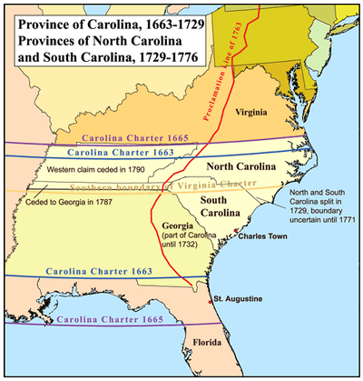
The Charter of 1663 chartered the territory as an English Proprietary colony assigning rights to eight English Noblemen. These noblemen are known as the Lords Proprietors of Carolina forming the Province of Carolina.
- George Monck, 1st Duke of Albemarle (1608–1670)
- Edward Hyde, 1st Earl of Clarendon (1609–1674)
- John Berkeley, 1st Baron Berkeley of Stratton (1607–1678)
- William Craven, 1st Earl of Craven (1608–1697)
- Sir George Carteret (c.1610–1680)
- Sir William Berkeley (1606–1677)
- Sir John Colleton, 1st Baronet (1608–1666)
- Anthony Ashley Cooper, 1st Earl of Shaftesbury (1621–1683).

Between 1663 and 1729 there were many disagreements relating to defense, governance and the difference between the two differing agrarian styles employed by the inhabitants of the Colony of Virginia and that practiced by the planters arriving to Charles Town from the West Indies and Barbados.
In 1729 the Province of Carolina was divided when the descendants of seven of the eight Lords Proprietors sold their shares back to the Crown. Only the heirs of Sir George Carteret retained their original rights to what would become the Granville District. Both the Province of North Carolina and the Province of South Carolina became English Crown Colonies in 1729.[2]
Culture
The culture of the Carolinas is a distinct subset of larger Southern culture. Notably, the coastal Carolina region was settled by Europeans over a century before the inland regions of the South,[3] and was influenced by the culture of the Caribbean, especially Barbados; many of the early governors during the unified period were Barbadians.[4] Though the two states both form part of the South, there are historically a number of significant differences in the settlement patterns, political development, and economic growth of the two states. For example, during the Civil War, South Carolina was the first Southern state to secede from the Union,[5] while North Carolina was the last state to secede.[6] During the war, South Carolina was generally one of the strongest supporters of the Confederacy. Many North Carolinians (especially in the western part of the state), however, refused to support the Confederacy at all; they either remained neutral or covertly supported the Union during the war. North Carolina's Civil War governor, Zebulon Vance, was an outspoken critic of Confederate President Jefferson Davis and frequently refused to obey Davis's orders for reinforcements and supplies; Vance insisted the soldiers and supplies were needed in North Carolina.[7]
Politics
During most of the 20th century, South Carolina was a bastion of the "solid Democratic South" with almost no Republican officeholders, and the state frequently elected politicians who were outspoken supporters of racial segregation. North Carolina, while mostly Democratic, contained a large Republican minority – the state voted Republican in the presidential election of 1928 and elected several Republican congressmen, governors, and senators from 1868–1928 – and North Carolina was widely known as one of the more progressive Southern states on the issue of segregation and civil rights. In 1947, the journalist John Gunther wrote, "that North Carolina is by a good deal the most progressive Southern state will, I imagine, be agreed to by almost everybody."[8] On the other hand, he described South Carolina as "one of the poorest American states, and probably one of the balkiest."[8] In describing the differences between the two states, Gunther noted that, in 1947, divorce in North Carolina "may be granted simply on the ground of absence of cohabitation; South Carolina is the one American state in which divorce is not possible."[8] North Carolina's nickname for many years was "a vale of humility between two mountains of conceit"; the "mountains" were Virginia and South Carolina.[8]
Despite North Carolina being a swing state, and South Carolina being a red one, they are technically the country's two most politically similar states, according to a comparison of the states along a range of 19 variables performed by the statistician Nate Silver in 2008.[9]
Economy
Traditionally, like much of the South, the Carolinas have been agricultural.[10] However, the predominance of certain crops has influenced the regional economy:
Like other [Southern] states, until after World War II North Carolina remained primarily a region of small farms and factories heavily dependent on just a few labor-intensive crops, relying on sharecropping and tenancy, especially for black laborers. The Carolinas are distinct for their economic dependence on tobacco as well as on cotton and rice, and for their many small-scale furniture, textile, and tobacco factories.[11]

These small industries gave the Carolinas, in particular NC, a more significant industrial base than most Southern states, but as increased mechanization in the textiles, apparel, and furniture industries combined with the decline of the tobacco industry,[12] many rural and small urban communities suffered.[13] However, during the 1990s, both states began to experience growth in the technological and banking sectors, bringing jobs and population growth.[14] These changes, as with earlier industrialization, were more pronounced in North Carolina, and SC has experienced a slower rate of economic growth for several years.[15]
Professional sports
| Club | League | Sport | City | Established | Championships |
|---|---|---|---|---|---|
| Carolina Panthers | NFL | Football | Charlotte, North Carolina | 1995 | 2 Super Bowl Appearances/Conference titles, 6 Division titles (1-NFC West, 5-NFC South) |
| Carolina Hurricanes | NHL | Hockey | Raleigh, North Carolina | 1997 | 1 Stanley Cup, 2 Conference Titles, 3 Division titles |
| Charlotte Hornets | NBA | Basketball | Charlotte, North Carolina | 1988 | none |
| Charlotte Hounds | MLL | Lacrosse | Charlotte, North Carolina | 2011 | none |
The Carolinas have three professional sports teams in the Big Four major leagues. Supported by both states, the three teams are all based in NC, two in Charlotte and the third in Raleigh. All of the sports teams are fairly recent additions; the oldest team, the NFL's Panthers, was established in 1995, while the youngest, the Hornets, was added to the NBA in 2004 as the Charlotte Bobcats, although a prior NBA team also named the Hornets played in Charlotte from 1988 before leaving for New Orleans in 2002. the Bobcats were renamed the Hornets in May 2014, one season after the former New Orleans Hornets decided to rebrand themselves as the Pelicans. Of all the teams, the Hurricanes are the most successful, being the only team with a championship.
The Carolinas are home to a number of NBA superstars, such as Chris Paul, James Worthy, John Wall, and Michael Jordan (from NC) and Kevin Garnett, Jermaine O'Neal, Ray Allen, and Raymond Felton (from SC). Six of these players are All Stars, four are NBA champions, and John Wall and James Worthy were the Number 1 draft picks in the 2010 NBA draft and 1982 NBA draft, respectively. A disproportional number of basketball players come from the Carolinas, on par with such big cities as New York City and Los Angeles. While the Hornets do little to generate buzz in the Carolinas, they are home to three of the most successful collegiate men's basketball teams in the NCAA, the North Carolina Tarheels, North Carolina State Wolfpack and the Duke Blue Devils. All three schools are fierce rivals who have combined to win 12 NCAA Men's Division I Basketball Championships (UNC has 5, Duke has 5, North Carolina State has 2).
Boundary between the states
Plotting the boundary
According to the Prefatory Notes to Volume 5 of the Colonial Records of North Carolina, the process of determining the boundary between North and South Carolina began in 1720 "when the purpose to erect a third Province in Carolina, with Savannah for its northern boundary"[16] began. On 8 January 1730[17] an agreement between the two colonies said for the border "to begin 30 miles southwest of the Cape Fear river, and to be run at that parallel distance the whole course of said river;" The next June Governor Robert Johnson of South Carolina said the border should start 30 miles southwest of the source of the Cape Fear "due west as far as the South Sea", unless the "Waccamaw river lyes [sic] within 30 miles of the Cape Fear river,"[16] which would make the Waccamaw the boundary. North Carolina agreed to this until the discovery that the Cape Fear headwaters were very close to Virginia, which would not have "permitted any extension on the part of North Carolina to the westward."[16] In 1732, Governor George Burrington of North Carolina stated in Timothy's Southern Gazette that territory north of the Waccamaw was in North Carolina, to which Johnson replied that South Carolina claimed the land. Johnson also said that when the two met before the Board of Trade in London two years earlier, Burrington had "insisted that the Waccamaw should be the boundary from its mouth to its head,"[16] while South Carolina agreed the border should be located 30 miles from the mouth, not the source. Johnson said this was "only a mistake in wording it."[16]
Both Carolinas selected commissioners to survey the line between them. The plan called for the line to run northwest to 35 degrees latitude, unless the Pee Dee River was reached first, in which case it would run along the Pee Dee to 35 degrees north. Then the line would run west to Catawba town, though if the town were north of the line, the line was to run around Catawba to keep it in South Carolina.[16]
In May 1735, the surveyors went from the Cape Fear westward thirty miles along the coast. Then they turned northwest and marked the location with stakes. The surveyors agreed to meet again on September 18. However, only the North Carolina team returned at that time, extending the line northwest 70 miles. The South Carolina team arrived in October and only followed the previous line for 40 miles because they had not been paid. A deputy surveyor marked where the Pee Dee crossed the 35th parallel. An extension of the line in 1737 ran 22 miles to a stake in a meadow.[16] However, the stake placed at the endpoint of the survey was 12 miles too far south.[18]
In 1764, a second extension ran 62 miles westward. In 1772, after making adjustments to keep the Catawba Indians in South Carolina, "extended in a due west course from the confluence of the north and south forks of the Catawba River to Tryon Mountain."[16] However, this extension was based on the erroneous position of the 1737 stake, removing 422,000 acres from South Carolina.[18] Joseph Caldwell, president of the University of North Carolina at Chapel Hill, found that the line west of the Pee Dee did not run along the 35th parallel, but 12 miles to the south. However, the western part of the line ran far enough to the north to make up for the difference.[16] West of this point the border was shifted to run north of the 35th parallel so that the total areas of the states would return to what was intended, although the accuracy of this part of the survey was marred by a magnetic anomaly in the Charlotte, North Carolina area.[18]
North Carolina did not agree to the line of 1772 until 1813.[16] A 1905 survey determined the border between Scotland County, North Carolina and Marlboro County, South Carolina. A 1928 survey decided the border between Horry County, South Carolina and Brunswick and Columbus counties in North Carolina.[19]
Recent history
In the mid-1990s, Duke Energy determined that the border between the Carolinas needed to be re-surveyed, as the company was selling and donating land in the Jocassee Gorge area, which included parts of both states.[18] Also, with more people living outside cities, the precise boundaries of fire, tax, and school district lines needed to be known. This was especially a problem in the mountains, where people had previously lived in valleys, not on the ridges where the border was. A 15-year plan to re-establish the boundary began, using maps from the 1813–1815 survey and GPS technology. A few stone markers still read, "NC/SC 1815 AD"[20] but other locations were marked with trees which no longer stand.[18]
South Carolina had recently been involved in a costly legal battle with Georgia over a small number of islands in the Savannah River, and wanted to avoid the expense of a lawsuit regarding the North Carolina border, so the two states agreed in 1993 to cooperate in resurveying the border. The effort included using colonial-era maps to reconstruct the positions of trees making the border that had long since died, and tracking down the original positions of stone markers that had been moved.[18]
After 18 years and $980,000, it was predicted that the process of determining the border between the Carolinas would be complete in 2012.[19] Financial problems delayed the last survey until October 2012, meaning the results were not expected to be known until Spring 2013.[21] A gas station and 30 homes could change states. Lake Wylie Minimarket has been located in South Carolina, along U.S. Route 321, and the move to North Carolina would result in higher gas taxes and change laws on beer and fireworks.[22] The state legislatures involved expect to pass laws alleviating the concerns those changing states would face.[21]
The Joint Boundary Commission met in February 2014 in Monroe, North Carolina to determine what actions still needed to be taken. The persons living in 50 homes that changed states would have to get driver's licenses and register to vote in their new states. Legislative action could allow people to keep utilities, avoid back taxes to the new state, and continue in the same schools. Lake Wylie Minimarket could be grandfathered, or Congress could change the defined border at the store's location, though the commission intended to avoid such an action.[23] As of August 2014, the states were expected to pass legislation to mitigate many of the negative impacts to affected landowners.[18]
On June 1, 2016, the South Carolina House of Representatives passed a bill setting the border. North Carolina's Senate also passed a bill, which also had to clear the House. Three families who actually lived in North Carolina had South Carolina addresses, and 16 South Carolina residents had believed they lived in North Carolina.[24]
Major population centers
Combined Statistical Areas
Metropolitan Statistical Areas
Urban areas
| Rank | Urban Area | Population (2010) | Population (2000) | Change | Land Area (sq mi) |
|---|---|---|---|---|---|
| 1 | Charlotte, NC-SC | 1,249,442 | 758,927 | +64.63% | 741.5 |
| 2 | Raleigh, NC | 884,891 | 541,527 | +63.41% | 518.1 |
| 3 | Columbia, SC | 549,777 | 420,537 | +30.73% | 380.0 |
| 4 | Charleston-North Charleston, SC | 548,404 | 423,410 | +29.52% | 293.4 |
| 5 | Greenville, SC | 400,492 | 302,194 | +32.53% | 320.3 |
| 6 | Winston-Salem, NC | 391,024 | 299,290 | +30.65% | 322.6 |
| 7 | Durham, NC | 347,602 | 287,796 | +20.78% | 181.7 |
| 8 | Greensboro, NC | 311,810 | 267,884 | +16.40% | 185.2 |
Counties
| Rank | County | Population (2015) | Population (2010) | Change | Area (sq mi) |
Primary City |
|---|---|---|---|---|---|---|
| 1 | Mecklenburg County, North Carolina | 1,034,070 | 919,628 | +12.44% | 546 | Charlotte, North Carolina |
| 2 | Wake County, North Carolina | 1,024,198 | 900,993 | +13.67% | 857 | Raleigh, North Carolina |
| 3 | Guilford County, North Carolina | 517,600 | 488,406 | +5.98% | 658 | Greensboro, North Carolina |
| 4 | Greenville County, South Carolina | 491,863 | 451,225 | +9.01% | 795 | Greenville, South Carolina |
| 5 | Richland County, South Carolina | 407,051 | 384,504 | +5.86% | 772 | Columbia, South Carolina |
| 6 | Charleston County, South Carolina | 389,262 | 350,209 | +11.15% | 1,358 | Charleston, South Carolina |
Cities
| Rank | County | Population (2015) | Population (2010) | Change | Area (sq mi) |
|---|---|---|---|---|---|
| 1 | Charlotte, North Carolina | 827,097 | 731,424 | +13.08% | 297.7 |
| 2 | Raleigh, North Carolina | 451,066 | 403,892 | +11.68% | 144.8 |
| 3 | Greensboro, North Carolina | 285,342 | 269,666 | +5.81% | 131.2 |
| 4 | Columbia, South Carolina | 133,803 | 129,272 | +3.51% | 134.9 |
| 5 | Charleston, South Carolina | 132,609 | 120,083 | +10.43% | 127.5 |
| 6 | Greenville, South Carolina | 64,579 | 58,409 | +10.56% | 26.1 |
See also
- Cuisine of the Southern United States
- Politics of the Southern United States
- Southern American English
- The Californias
- The Canadas
- The Dakotas
- The Floridas
- The Virginias
References
- ↑ Swedish Encyclopedia "Nordisk Familjebok", third edition, printed in 1942, volume 4 of 23, article "Carolina". It covers the entire part above
- ↑ The Split – One Colony Becomes Two from carolana.com
- ↑ Carolina Folk: The Cradle of a Southern Tradition. McKissick Museum. Columbia, South Carolina: University of South Carolina Press. 2006. p. 33. ISBN 0-87249-950-2. Retrieved 7 June 2008.
- ↑ "SCIway News No. 43". May 2007. Retrieved 7 June 2008.
- ↑ "A Brief History of South Carolina". South Carolina Department of Archives and History. Archived from the original on 23 April 2008. Retrieved 7 June 2008.
- ↑ Robert Morgan (22 August 2003). "The Bill of Rights Belongs in North Carolina". New York Times. Retrieved 7 June 2008.
- ↑ "Book Review: War Governor of the South". The Journal of American History. September 2006. Archived from the original on 30 August 2008. Retrieved 7 June 2008.
- 1 2 3 4 Gunther, John (1947). Inside U.S.A. (50th Anniversary ed.). New Press. pp. 719–723. ISBN 978-1-56584-358-5.
- ↑ Nate Silver (7 July 2008). "State Similarity Scores". FiveThirtyEight.com. Retrieved 7 July 2008.
- ↑ See Wallace Stevens's poem "In the Carolinas" for a reference to the fertility of this part of the world.
- ↑ Williams, B. (1988). Upscaling Downtown: Stalled Gentrification in Washington. Anthropology of contemporary issues. Cornell University Press. p. 13. ISBN 978-0-8014-9419-2. Retrieved 2015-09-11.
- ↑ "Tobacco-Dependent Communities Research Initiative". N.C. Rural Economic Development Center. 2000–2005. Archived from the original on 1 June 2008. Retrieved 7 June 2008.
- ↑ "Rural Dislocated Worker Initiative". N.C. Rural Economic Development Center. 2000–2007. Archived from the original on 14 August 2007. Retrieved 7 June 2008.
- ↑ "North Carolina". American Planning Association. Archived from the original on 11 May 2008. Retrieved 7 June 2008.
- ↑ Jim DuPlessis (6 June 2008). "U.S. economic growth matches S.C. at 2 percent in 2007". TheState.com. Retrieved 7 June 2008.
- 1 2 3 4 5 6 7 8 9 10 "History of Western North Carolina – Chapter II. Boundaries". webroots. Archived from the original on 3 December 2008. Retrieved 5 April 2011.
- ↑ "Carolina Noteworthy Events – The North Carolina-South Carolina Border Surveys – 1730 to 1815". carolana.com. Retrieved 5 April 2011.
- 1 2 3 4 5 6 7 Kelly, Stephen R. (23 August 2014). "How the Carolinas Fixed Their Blurred Lines". The New York Times. Retrieved 23 August 2014.
- 1 2 Beam, Adam (12 February 2012). "N.C.-S.C. border may move". The State. Archived from the original on 12 February 2012. Retrieved 29 February 2012.
- ↑ Dan Huntley, "Surveyors to Separate Carolinas, Precisely", The Charlotte Observer, 27 December 2001.
- 1 2 Beam, Adam (2 December 2012). "New SC-NC line delayed until spring". The State.
- ↑ Severson, Kim (5 April 2012). "Untangling a Border Could Leave a Mess for Some". The New York Times. Retrieved 19 April 2012.
- ↑ Collins, Jeffrey (7 February 2014). "Officials discuss legislation over North, South Carolina border". Augusta Chronicle. Associated Press. Retrieved 11 March 2014.
- ↑ "SC House passes bill clarifying border between Carolinas". The Charlotte Observer. Associated Press. 1 June 2016. Retrieved 2 June 2016.
Further reading
- John Gunther. Inside USA, Harper & Brothers, 1947.
External links
-
 Media related to The Carolinas at Wikimedia Commons