Carbon Glacier
| Carbon Glacier | |
|---|---|
|
The accumulation zone of the Carbon Glacier is fed from avalanches off Willis Wall (behind). | |
 Carbon Glacier | |
| Type | Mountain glacier |
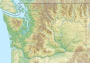
| Coordinates | 46°56′30″N 121°46′30″W / 46.94167°N 121.77500°WCoordinates: 46°56′30″N 121°46′30″W / 46.94167°N 121.77500°W[1] |
| Area | 3.1 sq mi (8.0 km2) |
| Length | 5.7 mi (9.2 km) |
| Thickness | 700 ft (210 m) |
| Terminus | Moraine |
| Status | Retreating |
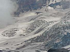
Carbon Glacier is located on the north slope of Mount Rainier in the U.S. state of Washington and is the source of the Carbon River.[2] The snout at the glacier terminal moraine is at about 3,500 feet (1,100 m) above sea level, making it the lowest-elevation glacier in the contiguous United States.[3] The glacier also has the greatest length (5.7 miles (9.2 km)), thickness (700 ft (210 m)) and volume (0.2 cubic miles (0.83 km3)) of any U.S. glacier outside of Alaska.
Carbon Glacier is accessible from the northwest Carbon River entrance of Mount Rainier National Park, just outside the town of Carbonado, Washington. The glacier is accessible on foot via an 8-mile (13 km) hike from the Carbon River entrance of Mt. Rainier National Park. The road and trail is currently washed out in several areas due to flooding of the Carbon River in 2006.
See also
References
- ↑ "Carbon Glacier". Geographic Names Information System. United States Geological Survey. Retrieved 2012-12-09.
- ↑ Mowich Lake, WA (Map). TopoQwest (United States Geological Survey Maps). Retrieved 2012-12-09.
- ↑ "Carbon Glacier Trail". National Park Service. Retrieved 2012-12-09.