Edmonton Capital Region
| Edmonton Capital Region Alberta Capital Region Greater Edmonton Metro Edmonton | |
|---|---|
| Metropolitan area | |
|
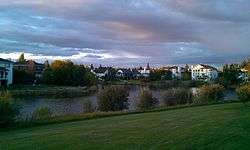
Downtown Edmonton skyline | |
| Coordinates: 53°34′N 113°31′W / 53.567°N 113.517°WCoordinates: 53°34′N 113°31′W / 53.567°N 113.517°W | |
| Province | Alberta |
| Country | Canada |
| Area (2011)[1] | |
| • Total | 9,426.73 km2 (3,639.68 sq mi) |
| Population (2011)[1] | |
| • CMA | 1,159,869 |
| • CMA density | 123.0/km2 (319/sq mi) |
| • Total | 1,278,962 |
| Time zone | MST (UTC-7) |
| • Summer (DST) | MDT (UTC-6) |
| Postal code span | T4X to T6X, T7X to T8R, T8T, T9E to T9G |
| Area code(s) | 780, 587, 825 |
| Highways | 2, 2A, 14, 15, 16, 16A, 19, 21, 28, 28A, 37, 39, 44, 60, 100, 216 |


The Edmonton Capital Region (ECR), also commonly referred to as the Alberta Capital Region, Greater Edmonton or Metro Edmonton, is a conglomeration of municipalities centred on Alberta's provincial capital of Edmonton.
The ECR's commonly known boundaries are coincident with those of the Edmonton census metropolitan area (CMA) as delineated by Statistics Canada. However, its boundaries are defined differently for Capital Region Board administrative purposes.[2]
The ECR is considered a major gateway to northern Alberta and the Canadian North, particularly for many companies, including airlines and oil/natural gas exploration. Located within central Alberta and at the northern end of the Calgary–Edmonton Corridor, the ECR is the northernmost metropolitan area in Canada.
Edmonton CMA
The Edmonton CMA includes the following 35 census subdivisions (municipalities or municipality equivalents):[3]
- five cities (Edmonton, Fort Saskatchewan, Leduc, St. Albert, and Spruce Grove);
- one specialized municipality (Strathcona County, which includes the Sherwood Park urban service area);
- three municipal districts (Leduc County, Parkland County, and Sturgeon County);
- ten towns (Beaumont, Bon Accord, Bruderheim, Calmar, Devon, Gibbons, Legal, Morinville, Redwater, and Stony Plain);
- four villages (Spring Lake, Thorsby, Wabamun, and Warburg);
- eight summer villages (Betula Beach, Golden Days, Itaska Beach, Kapasiwin, Lakeview, Point Alison, Seba Beach, and Sundance Beach); and
- four Indian reserves for three First Nations (Alexander 134 of the Alexander First Nation, Stony Plain 135 of the Enoch Cree Nation, and Wabamun 133A and 133B of the Paul First Nation).
The Edmonton CMA is the largest CMA in Canada by area at 9,426.73 km2 (3,639.68 sq mi).[1] In the 2011 Census, it had a population of 1,159,869, making it the sixth largest CMA in Canada by population.[1] The Edmonton CMA comprises the majority of Statistics Canada's Division No. 11 in Alberta.
Capital Region Board
A fragmentation in regional cooperation and partnership has long played a divisive role within the ECR. Particularly, Edmonton was frustrated that its surrounding municipalities were receiving an increased tax base for major industrial development, while not contributing to Edmonton's burden to maintain and build new infrastructure within Edmonton used by the residents and businesses of the surrounding municipalities.
After pulling out of the Alberta Capital Region Alliance (ACRA), Edmonton lobbied the provincial government to establish some form of regional government that would be more effective in fostering regional cooperation between it and its surrounding municipalities. As a result, Premier Ed Stelmach announced in December 2007 that a governing board would be established for Edmonton's Capital Region.[4] Four months later, the Capital Region Board (CRB) was formed with the passing of the Capital Region Board Regulation by Order in Council 127/2008 under the authority of the Municipal Government Act.[5]
Member municipalities
The CRB was originally established with 25 participating or member municipalities[6] – 23 of which were within the Edmonton CMA and two of which were outside the CMA (Lamont County and the Town of Lamont).[2] The number of member municipalities was reduced to 24 on September 10, 2010[7] after the Village of New Sarepta dissolved to hamlet status under the jurisdiction of Leduc County on September 1, 2010.[8]
Of the 35 census subdivisions within the Edmonton CMA,[3] the Village of Spring Lake, the eight summer villages and four Indian reserves are not members of the CRB.[2] Also, despite Bruderheim and Lamont being urban municipalities within Lamont County that are members of the CRB, the remaining urban municipalities within Lamont County - the Town of Mundare and the villages of Andrew and Chipman – are not members of the CRB.[2]
More specifically, the CRB includes:[9]
- Five cities (Edmonton, Fort Saskatchewan, Leduc, St. Albert, and Spruce Grove);
- One specialized municipality (Strathcona County, which includes the Sherwood Park urban service area);
- Four municipal districts (Lamont County, Leduc County, Parkland County, and Sturgeon County);
- Eleven towns (Beaumont, Bon Accord, Bruderheim, Calmar, Devon, Gibbons, Lamont, Legal, Morinville, Redwater, and Stony Plain); and
- Three villages (Thorsby, Wabamun, and Warburg)
Capital Region Growth Plan
Under the CRB Regulation, the CRB was tasked with preparing a growth plan to cover land use, intermunicipal transit, housing, and geographic information services components.[10] In March, 2010, Growing Forward: The Capital Region Growth Plan (CRGP), consisting of individual plans for these four components and two addenda, was approved by the Government of Alberta.[11]
The CRGP includes a population and employment forecast for the Capital Region. With a base population of 1.12 million in 2009, the CRB has forecasted the population of the Capital Region to reach 1.31 million by 2019.[12] The CRGP also designates priority growth areas and cluster country residential areas within the Capital Region.[13]
List of municipalities

The following is a list of municipalities in the Edmonton Capital Region, all of which are also within the Edmonton CMA. The Town of Lamont, Lamont County and members of the CRB are indicated accordingly.
| Municipality | Municipal status [14] |
Federal census population (2011) [3] |
Latest municipal census population (2007-2016) [15][16] |
Latest municipal census year [15] |
CRB member [9] |
Edmonton CMA [3] | |
|---|---|---|---|---|---|---|---|
| Alexander 134 | Indian reserve | 1,027 | 997 | 2009 | N | Y | |
| Beaumont | Town | 13,284 | 17,720 | 2016[17] | Y | Y | |
| Betula Beach | Summer village | 10 | N | Y | |||
| Bon Accord | Town | 1,488 | Y | Y | |||
| Bruderheim | Town | 1,155 | Y | Y | |||
| Calmar | Town | 1,970 | 2,101 | 2014 | Y | Y | |
| Devon | Town | 6,510 | 6,650 | 2014 | Y | Y | |
| Edmonton | City | 812,201 | 899,447 | 2016[18] | Y | Y | |
| Fort Saskatchewan | City | 19,051 | 24,569 | 2016[19] | Y | Y | |
| Gibbons | Town | 3,030 | 2,848 | 2007 | Y | Y | |
| Golden Days | Summer village | 141 | N | Y | |||
| Itaska Beach | Summer village | 20 | N | Y | |||
| Kapasiwin | Summer village | 10 | 14 | 2012 | N | Y | |
| Lakeview | Summer village | 26 | N | Y | |||
| Lamont | Town | 1,753 | Y | N | |||
| Lamont County | Municipal district | 3,872 | Y | N | |||
| Leduc | City | 24,279 | 30,498 | 2016[20] | Y | Y | |
| Leduc County | Municipal district | 13,541 | Y | Y | |||
| Legal | Town | 1,225 | Y | Y | |||
| Morinville | Town | 8,569 | 9,893 | 2016[21] | Y | Y | |
| Parkland County | Municipal district | 30,568 | 30,089 | 2009 | Y | Y | |
| Point Alison | Summer village | 15 | 10 | 2013 | N | Y | |
| Redwater | Town | 1,915 | 2,116 | 2012 | Y | Y | |
| Seba Beach | Summer village | 143 | N | Y | |||
| Spring Lake | Village | 533 | 614 | 2012 | N | Y | |
| Spruce Grove | City | 26,171 | 33,640 | 2016[22] | Y | Y | |
| St. Albert | City | 61,466 | 64,645 | 2016[23] | Y | Y | |
| Stony Plain | Town | 15,051 | 16,127 | 2015 | Y | Y | |
| Stony Plain 135 | Indian reserve | 987 | 1,554 | 2009 | N | Y | |
| Strathcona County | Specialized municipality | 92,490 | 95,597 | 2015 | Y | Y | |
| Sturgeon County | Municipal district | 19,578 | 19,165 | 2008 | Y | Y | |
| Sundance Beach | Summer village | 82 | N | Y | |||
| Thorsby | Village | 797 | 1,025 | 2015 | Y | Y | |
| Wabamun | Village | 661 | 662 | 2009 | Y | Y | |
| Wabamun 133A and 133B | Indian reserve | 1,086 | 1,293 | 2009 | N | Y | |
| Warburg | Village | 789 | 696 | 2009 | Y | Y | |
| Total Edmonton Census Metropolitan Area (CMA - 2011) | 1,159,869 | ||||||
| Total Edmonton Capital Region (ECR - 2011) | 1,165,494 | ||||||
- ^ Strathcona County's 2011 federal census population of 92,490 includes 64,733 in the Sherwood Park urban service area.[24]
- ^ Strathcona County's 2015 municipal census population of 95,597 includes 68,782 in Sherwood Park.[16]
- ^ The combined Wabamun 133A and 133B population of 1,086 includes 1,069 in Wabamun 133A and 17 in Wabamun 133B.[25]
- ^ Population including Lamont and Lamont County.[26][27]
Major industrial areas
Major industrial areas within the ECR include the northwest, southeast and Clover Bar industrial areas in Edmonton, Nisku Industrial Business Park in Leduc County, Acheson Industrial Area in Parkland County, Refinery Row in Strathcona County, and Alberta's Industrial Heartland spanning portions of Sturgeon County, Strathcona County, Lamont County and Fort Saskatchewan.
At the moment, two more major industrial areas are in the final stages of establishment. The establishment of the Horse Hills industrial area in northeast Edmonton is in the final planning stages, while Edmonton Airports is currently planning its inland port development under the Port Alberta initiative at the Edmonton International Airport within Leduc County.
See also
References
- 1 2 3 4 "Population and dwelling counts, for census metropolitan areas, 2011 and 2006 censuses". Statistics Canada. 2012-02-08. Retrieved 2012-02-13.
- 1 2 3 4 "Fact Sheet: Geographic Profile" (PDF). Capital Region Board. Retrieved 2012-02-13.
- 1 2 3 4 "Census Profile – Geographic hierarchy: Edmonton (Census metropolitan area)". Statistics Canada. 2012-02-08. Retrieved May 28, 2016.
- ↑ Archie McLean and Susan Ruttan (2007-12-19). "Mayor "elated" by new regional planning board". Edmonton Journal. Retrieved 2008-01-09.
- ↑ "Order in Council 127/2008". Alberta Queen's Printer. 2008-04-15. Retrieved 2009-12-24.
- ↑ "Order in Council (O.C.) 66/2010". Province of Alberta. 2010-03-15. Retrieved 2012-02-13.
- ↑ "Order in Council (O.C.) 316/2010". Province of Alberta. 2010-03-15. Retrieved 2012-02-13.
- ↑ "Order in Council (O.C.) 230/2010". Alberta Queen's Printer. Retrieved 2010-07-15.
- 1 2 "Capital Region Board Members". Capital Region Board. Retrieved 2012-02-13.
- ↑ "Capital Region Board". Capital Region Board. Retrieved 2012-01-21.
- ↑ "Capital Region Growth Plan: Growing Forward". Capital Region Board. Retrieved 2012-01-21.
- ↑ "The Capital Region Growth Plan Addendum" (PDF). Capital Region Board. December 2009. Retrieved 2012-01-21.
- ↑ "The Capital Region Growth Plan Addendum" (PDF). Capital Region Board. October 2009. Retrieved 2012-01-21.
- ↑ "2010 Municipal Codes" (PDF). Alberta Municipal Affairs. 2010-04-01. Retrieved 2010-09-03.
- 1 2 "2011 Municipal Affairs Population List" (PDF). Alberta Municipal Affairs. 2010-10-05. Retrieved 2012-12-19.
- 1 2 "2015 Municipal Affairs Population List" (PDF). Government of Alberta. Government of Alberta. Retrieved 28 May 2016.
- ↑ "2016 Municipal Census Results". Town of Beaumont. May 20, 2016. Retrieved May 28, 2016.
- ↑ "Municipal Census". City of Edmonton. August 31, 2016. Retrieved September 23, 2016.
- ↑ "Fort Saskatchewan population still on the rise". City of Fort Saskatchewan. June 9, 2016. Retrieved September 23, 2016.
- ↑ "City of Leduc crosses 30,000 threshold for 2016 census". City of Leduc. June 8, 2016. Retrieved September 23, 2016.
- ↑ Tristan Turner (July 13, 2016). "Morinville has 9,893 people according to completed municipal census". Morinville News. Pawn Marketing & Publishing Inc. Retrieved September 23, 2016.
- ↑ "Spruce Grove Demographic Report 2016". City of Spruce Grove. Retrieved September 23, 2016.
- ↑ "City Releases Census Results: Slow and Steady Growth Since 2014". City of St. Albert. June 20, 2016. Retrieved September 23, 2016.
- ↑ "Strathcona County experiences double-digit growth". Strathcona County. 2012-02-09. Retrieved 2012-02-10.
- ↑ "Population and dwelling counts, for Canada, provinces and territories, and census subdivisions (municipalities), 2011 and 2006 censuses". Statistics Canada. Government of Canada. Retrieved 28 May 2016.
- ↑ "Lamont, Town (Census Subdivision), Alberta". Statistics Canada. Government of Canada. Retrieved 28 May 2016.
- ↑ "Lamont County, Municipal district (Census Subdivision), Alberta". Statistics Canada. Government of Canada. Retrieved 28 May 2016.
External links
- Capital Region Board
- Edmonton.com - Portal to Greater Edmonton
- EEDC - Edmonton Economic Development Corporation
- Edmonton's International Region

| Subdivisions | |
|---|---|
| Communities | |
| Cities and urban service areas | |
| Regions | |
| |
| Features | |
|---|---|
| History | |
| Geography |
|
| Economy | |
| Politics |
|
| Public services |
|
| Education |
|
| Culture |
|
| Transportation and infrastructure | |