Cape Point
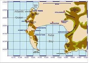
Cape Point is a promontory at the southeast corner of the Cape Peninsula, which is a mountainous and scenic landform that runs north-south for about thirty kilometres at the extreme southwestrn tip of the African continent in the Republic of South Africa. Table Mountain and the city of Cape Town are close to the northern extremity of the same peninsula. The cape is located at 34°21′26″S 18°29′51″E / 34.35722°S 18.49750°ECoordinates: 34°21′26″S 18°29′51″E / 34.35722°S 18.49750°E, about 2.3 kilometres (1.4 mi) east and a little north of the Cape of Good Hope on the southwest corner.[1] Although these two rocky capes are very well known, neither cape is actually the southernmost point of the mainland of Africa; that is Cape Agulhas, approximately 150 kilometres (93 mi) to the east-southeast.
Peaks
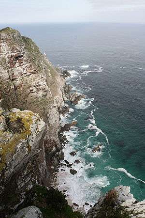
The peak above Cape Point is higher than that above the Cape of Good Hope. The rugged sandstone (Table Mountain sandstone) ridge that rises from Cape Point at sea level develops into two peaks. There is a major peak that dominates the skyline locally but there is also a smaller peak about 100 m (328 ft) further south. The higher peak has the old lighthouse on the top. The Flying Dutchman Funicular runs from a car park to the north up to slightly below the level of the old lighthouse and a short flight of steps leads to a viewing platform around the base of the lighthouse. From the end of the railway a second path leads to the lower peak.
Lighthouse

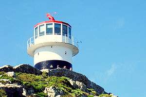
The new lighthouse is at a lower elevation (87 meters; 285.5 feet above sea level), for two reasons: the old lighthouse, located at 34°21′12″S 18°29′25.2″E / 34.35333°S 18.490333°E, could be seen 'too early' by ships rounding the point towards the east, causing them to approach too closely. Secondly, foggy conditions often prevail at the higher levels, making the older lighthouse invisible to shipping. On 18 April 1911, the Portuguese liner Lusitania was wrecked just south of Cape Point at 34°23′22″S 18°29′23″E / 34.38944°S 18.48972°E on Bellows Rock for precisely this reason, prompting the relocation of the lighthouse.
The new lighthouse, located at 34°21′26″S 18°29′49″E / 34.35722°S 18.49694°E, cannot be seen from the West until ships are at a safe distance to the South. The light of the new Cape Point lighthouse is the most powerful on the South African coast, with a range of 63 miles (101 km; 55 nmi) and an intensity of 10 megacandelas in each flash.[2]
Other facts
Cape Point is situated within the Table Mountain National Park, within a section of the park referred to as Cape of Good Hope. This section covers the whole of the southern tip of the Cape Peninsula and which takes in perhaps 20% of its total area.[3] The Cape of Good Hope section of the park is generally wild, unspoiled and undeveloped and is an important haven for seabirds. The vegetation at Cape Point consists primarily of Peninsula Sandstone Fynbos.
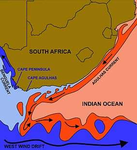
Cape Point is often mistakenly claimed to be the place where the cold Benguela Current of the Atlantic Ocean and the warm Agulhas Current of the Indian ocean collide. In fact, the meeting point fluctuates along the southern and southwestern Cape coast, usually occurring between Cape Agulhas and Cape Point. The two intermingling currents help to create the micro-climate of Cape Town and its environs. Contrary to popular mythology, the meeting point of the currents produces no obvious visual effect; there is no "line in the ocean" where the sea changes colour or looks different in some way. There are, however, strong and dangerous swells, tides and localized currents around the point and in adjacent waters. These troubled seas have witnessed countless maritime disasters in the centuries since ships first sailed here.
Fishing is good along the coast but the unpredictable swells make angling from the rocks very dangerous. Over the years scores of fishermen have been swept to their deaths from the rocky platforms by freak waves. False Bay, which opens to the east and north of Cape Point, is the location of the well-known naval port of Simon's Town. The bay is also famous - or infamous - for its great white sharks, which hunt the Cape fur seals that live in the area.
Climate research
Cape Point is the site of one of the Global Atmosphere Watch's atmospheric research stations. In the early years of the 20th century icebergs from Antarctica were occasionally sighted from Cape Point. There have been no authentic recent sightings of ice, which some climatologists and experts have attributed to global warming.
References
| Wikimedia Commons has media related to Cape Point. |
- ↑ Topo map of Cape Point, from the South African Geographical Names System
- ↑ Cape Point Attractions: Cape Point, Cape Town, South Africa, from South Africa Explored
- ↑ Map of the park, showing the Cape Point section.