Cape Patience
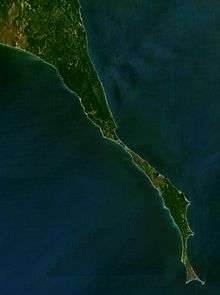
View of Cape Patience from space.
.svg.png)
This map shows Poronaysky District; Cape Patience is the skinny peninsula in the southeastern part.
Cape Patience (Russian: Полуостров Терпения, Poluostrov Terpeniya) is a peninsula protruding 65 km (40 mi) km of east-central Sakhalin Island into the Sea of Okhotsk. It forms the eastern boundary of the Gulf of Patience. The width of the peninsula varies from less than 1 km (0.62 mi), at the Lodochniy Isthmus, to 30 km (19 mi) at its widest point. It reaches a maximum elevation of 350 m (1,150 ft). The cape is the southernmost extension (on land) of the East Sakhalin Mountains, a north-south range that runs along the eastern side of Sakhalin Island.[1]
There is a small lighthouse at the end of the cape, which was built in 1953.[2]
References
- ↑ ov, E. P., A. V. Mozherovsky, M. T. Gorovaya, I. B. Tsoy, and N. G. Vashchenkova. Composition of the Rocks of the Kotikovo Group and the Main Stages in the Late Cretaceous-Paleogene Evolution of the Terpeniya Peninsula, Sakhalin Island. Russian Journal of Pacific Geology 4.3 (2010): 260-73.
- ↑ Lighthouse Explorer Database ... Terpeniya Light. Foghorn Publishing, Lighthouse Explorer Database. Retrieved 22 Sept. 2012.
Coordinates: 48°54′N 144°35′E / 48.900°N 144.583°E
This article is issued from Wikipedia - version of the 10/2/2015. The text is available under the Creative Commons Attribution/Share Alike but additional terms may apply for the media files.