Cape Leveque
 Cape Leveque lighthouse | |
 Western Australia | |
| Location |
Cape Leveque the northern edge of the Dampier Peninsula Western Australia |
|---|---|
| Coordinates | 16°23′42″S 122°55′42″E / 16.394908°S 122.928426°E |
| Year first constructed | 1912 |
| Construction | steel (?) |
| Tower shape | conical frustum tower with balcony and lantern |
| Markings / pattern | white tower and lantern |
| Height | 13 metres (43 ft) |
| Focal height | 43 metres (141 ft) |
| Characteristic | Fl (3) W 20 s. |
| Admiralty number | K1650 |
| NGA number | 9452 |
| ARLHS number | AUS-036 |
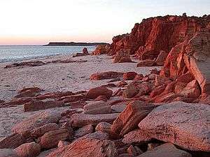
Cape Leveque is the northernmost tip of the Dampier Peninsula in the Kimberley region of Western Australia. Cape Leveque is 240 kilometres (150 mi) (via the Cape Leveque Road) north of Broome, and is remote with few facilities. Nevertheless, the Cape's sandy beaches are attracting an increasing number of visitors.
A 13-metre (43 ft)-tall lighthouse was erected at Cape Leveque in 1912. Its light characteristic is a group of three flashes that occurs every twenty seconds whereby the light source emits from a focal plane of 43 metres (141 ft).[1] The lighthouse marks the western entrance of King Sound.
Cape Leveque was a camping ground for ancient nomadic people of Northern Australia and is probably still being used today. Their huge middens overshadow the small caravan park resting on the shores of the Indian Ocean. Wild turtles and a multitude of sea birds nest on the shores and collect sea food off the exposed rocks at low tide along the shore down the coast to Broome in the Southern part of the peninsula. Whales come to give birth in the area and rest and play among the sheltered islands off the Dampier Peninsula.
The traditional owners of the area are the Bardi peoples.[2]
William Dampier's description from the Cygnet off Cape Lévêque on 5 January 1688: "This part is all a low, even land with sandy banks against the sea … the points rocky and so are some of the islands in the bay… The soil is dry and sandy, destitute of water, except you make wells, yet producing divers sorts of trees."[3]
In January 2015, the locality recorded rainfall in excess of 400mm [4]
See also
References
- ↑ Rowlett, Russ (2009-04-22). "Lighthouses of Australia: Western Australia". The Lighthouse Directory. University of North Carolina at Chapel Hill. Retrieved 2009-04-27.
- ↑ "Ausanthrop - Australian Aboriginal tribal database". ausanthrop.net. 2012. Archived from the original on 17 August 2010. Retrieved 2015-01-10.
- ↑ Lee, I., 1925. Early Explorers in Australia From the Log-Books and Journals
- ↑ "Record rainfall in remote Cape Leveque on Dampier Peninsula in the Kimberley - ABC News (Australian Broadcasting Corporation)". abc.net.au. Retrieved 2015-01-10.
External links
| Wikimedia Commons has media related to Cape Leveque Lighthouse. |
Coordinates: 16°23′28″S 122°55′37″E / 16.391°S 122.927°E