Cape James
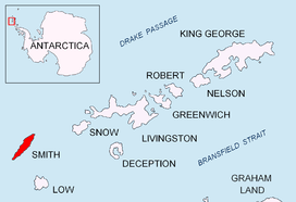

Cape James is a cape which forms the southern tip of Smith Island in the South Shetland Islands, Antarctica. The name appears on a chart based upon the 1828–31 British naval expedition under Captain Henry Foster, and is now well established in international usage.[1]
Location
The point is located at 63°05′50″S 62°43′01″W / 63.09722°S 62.71694°WCoordinates: 63°05′50″S 62°43′01″W / 63.09722°S 62.71694°W which is 4.5 kilometres (2.8 mi) south-southwest of Elin Pelin Point, 6.8 kilometres (4.2 mi) southwest of Organa Peak, 3.55 kilometres (2.2 mi) west-southwest of Suhindol Point and 29.5 kilometres (18.3 mi) northwest of Low Island (Bulgarian mapping in 2009).
Map
- L.L. Ivanov. Antarctica: Livingston Island and Greenwich, Robert, Snow and Smith Islands. Scale 1:120000 topographic map. Troyan: Manfred Wörner Foundation, 2009. ISBN 978-954-92032-6-4
References
- ↑ "James, Cape". Geographic Names Information System. United States Geological Survey. Retrieved 2012-07-16.
![]() This article incorporates public domain material from the United States Geological Survey document "James, Cape" (content from the Geographic Names Information System).
This article incorporates public domain material from the United States Geological Survey document "James, Cape" (content from the Geographic Names Information System).