Cape Flattery
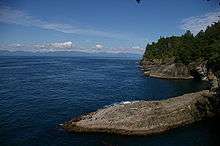
Cape Flattery is the northwesternmost point of the contiguous United States. It is in Clallam County, Washington on the Olympic Peninsula, where the Strait of Juan de Fuca joins the Pacific Ocean. It is also part of the Makah Reservation,[1] and is the northern boundary of the Olympic Coast National Marine Sanctuary. Cape Flattery can be reached from a short hike, most of which is boardwalked.[2] The westernmost point in the contiguous United States is at Cape Alava, south of Cape Flattery in Olympic National Park. However, the westernmost tip of Cape Flattery is almost exactly as far west as Cape Alava, the difference being approximately 5 seconds of longitude, about 360 feet (110 m), at high tide and somewhat more at low tide.[3]
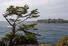
The Cape Flattery Lighthouse is on Tatoosh Island, just off the cape. Makah Bay and Neah Bay are on either side of the cape. Neah Bay, Washington is the closest town to the cape.
History
James Cook
Cape Flattery is the oldest permanently named feature in Washington state, being described and named by James Cook on March 22, 1778. Cook wrote: "... there appeared to be a small opening which flattered us with the hopes of finding an harbour ... On this account I called the point of land to the north of it Cape Flattery."[4][5]
Japanese castaways in 1834
In 1834, the first Japanese known to have arrived in what is now Washington state arrived in a dismasted, rudderless ship that ran aground near Cape Flattery. The three survivors of the broken ship were held as slaves by the local Makah people before being taken to Fort Vancouver by William H. McNeill under orders from John McLoughlin.[6]
Fuca Pillar
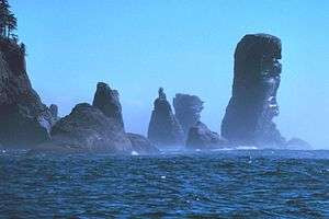
Fuca Pillar is a tall, almost rectangular, rock on the west side of Cape Flattery. It is named after Juan de Fuca, a Greek sailor who explored for Spain. Fuca has a doubtful claim to being the first European explorer to see the Fuca Pillar and to explore the Strait of Juan de Fuca, also named for him. The first generally accepted mention of the pillar was by John Meares in 1788.[4]
Literary references
The novel When Wolf Comes by John Pappas is set in Cape Flattery in 1801. Parts of the novel Freaky Green Eyes by Joyce Carol Oates are set here in present day.
Ma and Pa Kettle movies were set in Cape Flattery.
The children's novel Ghost Canoe by Will Hobbs is set on Tatoosh Island and Neah Bay in 1874.
Notes
- ↑ "Cape Flattery Trail". Makah Tribe. Retrieved 11 September 2010.
- ↑ Logan, Jeff (2010). "Cape Flattery trail". North Olympic Peninsula Insider. Retrieved 11 September 2010. Cape Flattery Trail, with photographs.
- ↑ NOAA Chart 18460, Strait of Juan de Fuca Entrance, 1/100,000, 2006
- 1 2 Majors, Harry M. (1975). Exploring Washington. Van Winkle Publishing Co. p. 9. ISBN 978-0-918664-00-6.
- ↑ Gannett, Henry (1905). The Origin of Certain Place Names in the United States. Govt. Print. Off. p. 126.
- ↑ Tate, Cassandra (2009-07-23). "HistoryLink: Japanese Castaways of 1834: The Three Kichis". HistoryLink.org.
| Wikimedia Commons has media related to Cape Flattery. |
Coordinates: 48°22′59″N 124°42′52″W / 48.3831179°N 124.7144109°W