Lee County, Florida
| Lee County, Florida | ||
|---|---|---|
| ||
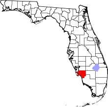 Location in the U.S. state of Florida | ||
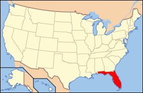 Florida's location in the U.S. | ||
| Founded | May 13, 1887 | |
| Named for | Robert E. Lee | |
| Seat | Fort Myers | |
| Largest city | Cape Coral | |
| Area | ||
| • Total | 1,212 sq mi (3,139 km2) | |
| • Land | 785 sq mi (2,033 km2) | |
| • Water | 428 sq mi (1,109 km2), 35.3% | |
| Population (est.) | ||
| • (2015) | 701,982 | |
| • Density | 769/sq mi (297.1/km²) | |
| Congressional districts | 17th, 19th | |
| Time zone | Eastern: UTC-5/-4 | |
| Website |
www | |

Lee County is a county in the State of Florida. As of the 2010 census, the population was 618,754.[1] The county seat is Fort Myers,[2] and the largest city is Cape Coral.
Lee County comprises the Cape Coral–Fort Myers, FL Metropolitan Statistical Area.
History
Lee County was created in 1887 from Monroe County.[3] It was named for Robert E. Lee, Confederate general in the American Civil War.[4]
Incorporated in 1886, Fort Myers is the center of a popular tourist area in Southwest Florida and the seat of Lee County. It is about 120 miles (190 km) south of Tampa at the meeting point of the Gulf of Mexico and the Caloosahatchee River. Fort Myers was the frequent winter home of Thomas Edison, as well as Henry Ford.[5] Lee County has been the host to several Major League Baseball teams for Spring Training, over the past several decades. Currently, it is the spring home of the Boston Red Sox, as well as the Minnesota Twins.
Fort Myers, built in 1850 as a military fort to fend off Seminole Indians, was named after Col. Abraham C. Myers, who was stationed in Florida for seven years and was the son-in-law of the fort’s establisher and commander. In 1858, after years of elusive battle, chief Billy Bowlegs and his warriors were persuaded to surrender and move west, and the fort was abandoned. Billy’s Creek, which flows into the Caloosahatchee River, was named after a temporary camp where Billy Bowlegs and his men awaited ships to take them west.
In 1863, the fort was reoccupied by Federal troops during the Civil War. In 1865 the fort was attacked unsuccessfully by a small group of Confederates. After the war, the fort was again deserted.
The first settlers arrived in 1866, but it was not until 1882 when the city experienced a significant influx of settlers. By 1885, when Fort Myers was incorporated, it was the second largest city only to Tampa on Florida’s west coast south of Cedar Key, even larger than Clearwater and Sarasota, also growing cities at the time.
Fort Myers first became a nationally known winter resort with the building of The Royal Palm Hotel in 1898. But what really sparked the city’s growth was the construction of the Tamiami Trail Bridge built across the Caloosahatchee River in 1924. After the bridge’s construction, the city experienced its first real estate boom and many subdivisions sprouted around the city.
In the 1870’s, Tervio Padilla, a wealthy merchant from the Canary Islands, came by way of Key West to Cayo Costa and established trade with natives and “ranchos” that extended northward to Charlotte Harbor. His ships often made port at Cayo Costa at the entrance to the harbor. Enchanted by the tropical island, he eventually decided to settle there. Padilla prospered until the outbreak of the Spanish-American War when his fleet was burned and scuttled. He then turned to another means of livelihood – fishing. When the government claimed his land he was disinclined to set up another ranch so moved with his wife further down the island and as before, simply homesteaded . The Padilla family is one of the first pioneer families of Lee County and many still reside within the county mainly around the Pine Island area.
In 1923, Collier and Hendry Counties were created by splitting these areas from Lee County.
On August 13, 2004, the county was struck by Hurricane Charley, a Category 4 storm, particularly on the northwestern islands of Captiva, Gasparilla and North Captiva.
Geography
According to the U.S. Census Bureau, the county has a total area of 1,212 square miles (3,140 km2), of which 785 square miles (2,030 km2) is land and 428 square miles (1,110 km2) (35.3%) is water.[6] Rivers and streams include the Caloosahatchee River, the Imperial River, the Estero River, Hendry Creek, and Orange River.
Lee County is on the southwest coast of Florida. It is approximately 125 miles (201 km) south of Tampa and 115 miles (185 km) west of Fort Lauderdale via Interstate 75; and approximately 125 miles (201 km) west-northwest of Miami via U.S. Highway 41.
Adjacent counties
- Charlotte County (north)
- Glades County (northeast)
- Collier County (southeast)
- Hendry County (east)
National protected areas
- Caloosahatchee National Wildlife Refuge
- J.N. "Ding" Darling National Wildlife Refuge
- Matlacha Pass National Wildlife Refuge
- Pine Island National Wildlife Refuge
Islands
- Big Hickory Island
- Captiva Island
- Cayo Costa (Cayo Costa State Park)
- Cabbage Key
- Estero Island (Town of Fort Myers Beach)
- Gasparilla Island (community of Boca Grande)
- Little Hickory Island (Beaches of Bonita Springs)
- Lovers Key / Carl E. Johnson State Park
- Matlacha Island
- Mound Key Archaeological State Park
- North Captiva Island
- Pine Island
- San Carlos Island
- Sanibel Island (Town of Sanibel)
- Useppa Island
Climate
Lee County has a year-round warm, monsoon-influenced climate that is close to the boundary between tropical and subtropical climates (18 °C (64 °F) in the coldest month), and is thus either classified as a humid subtropical climate (Köppen Cfa), which is the classification used by NOAA,[7][8] or a tropical savanna climate (Köppen Aw).[9] Lee County has short, warm winters, and long, hot, humid summers, with most of the year's rainfall falling from June to September. The temperature rarely rises to 100 °F (38 °C) or lowers to the freezing mark.[10] At 89, Lee County leads the nation in the number of days annually in which a thunderstorm is close enough for thunder to be heard.[11] The monthly daily average temperature ranges from 64.2 °F (17.9 °C) in January to 83.4 °F (28.6 °C) in August, with the annual mean being 75.1 °F (23.9 °C). Records range from 24 °F (−4 °C) on December 29, 1894 up to 103 °F (39 °C) on June 16–17, 1981.[10]
| Climate data for Fort Myers, Florida (Page Field), 1981–2010 normals | |||||||||||||
|---|---|---|---|---|---|---|---|---|---|---|---|---|---|
| Month | Jan | Feb | Mar | Apr | May | Jun | Jul | Aug | Sep | Oct | Nov | Dec | Year |
| Record high °F (°C) | 90 (32) |
92 (33) |
93 (34) |
96 (36) |
99 (37) |
103 (39) |
101 (38) |
100 (38) |
98 (37) |
95 (35) |
95 (35) |
90 (32) |
103 (39) |
| Average high °F (°C) | 74.7 (23.7) |
77.2 (25.1) |
80.4 (26.9) |
84.6 (29.2) |
89.4 (31.9) |
91.5 (33.1) |
91.9 (33.3) |
91.8 (33.2) |
90.5 (32.5) |
86.7 (30.4) |
81.3 (27.4) |
76.6 (24.8) |
84.7 (29.3) |
| Average low °F (°C) | 53.7 (12.1) |
55.9 (13.3) |
59.4 (15.2) |
63.1 (17.3) |
68.7 (20.4) |
73.5 (23.1) |
74.5 (23.6) |
74.9 (23.8) |
74.3 (23.5) |
69.1 (20.6) |
62.0 (16.7) |
56.4 (13.6) |
65.5 (18.6) |
| Record low °F (°C) | 27 (−3) |
27 (−3) |
33 (1) |
39 (4) |
50 (10) |
58 (14) |
66 (19) |
65 (18) |
63 (17) |
45 (7) |
34 (1) |
24 (−4) |
24 (−4) |
| Average rainfall inches (mm) | 1.89 (48) |
2.13 (54.1) |
2.84 (72.1) |
2.02 (51.3) |
2.72 (69.1) |
10.28 (261.1) |
9.14 (232.2) |
10.21 (259.3) |
8.55 (217.2) |
2.67 (67.8) |
1.92 (48.8) |
1.69 (42.9) |
56.06 (1,423.9) |
| Average rainy days (≥ 0.01 in) | 5.5 | 5.2 | 6.2 | 4.2 | 6.8 | 16.0 | 17.6 | 17.9 | 15.4 | 6.8 | 4.4 | 4.5 | 110.5 |
| Source: NOAA (extremes 1892–present)[10] | |||||||||||||
Demographics
| Historical population | |||
|---|---|---|---|
| Census | Pop. | %± | |
| 1890 | 1,414 | — | |
| 1900 | 3,071 | 117.2% | |
| 1910 | 6,294 | 104.9% | |
| 1920 | 9,540 | 51.6% | |
| 1930 | 14,990 | 57.1% | |
| 1940 | 17,488 | 16.7% | |
| 1950 | 23,404 | 33.8% | |
| 1960 | 54,539 | 133.0% | |
| 1970 | 105,216 | 92.9% | |
| 1980 | 205,266 | 95.1% | |
| 1990 | 335,113 | 63.3% | |
| 2000 | 440,888 | 31.6% | |
| 2010 | 618,754 | 40.3% | |
| Est. 2015 | 701,982 | [12] | 13.5% |
| U.S. Decennial Census[13] 1790–1960[14] 1900–1990[15] 1990–2000[16] 2010–2015[1] | |||
2010 Census
U.S. Census Bureau 2010 Ethnic/Race Demographics:[17][18]
- White (non-Hispanic) (83.0% when including White Hispanics): 71.0% (17.0% German, 13.0% Irish, 11.1% English, 8.2% Italian, 3.7% Polish, 3.3% French, 2.2% Scottish, 1.7% Scotch-Irish, 1.5% Dutch, 1.3% Swedish, 1.1% Norwegian, 0.8% French Canadian, 0.8% Welsh, 0.8% Russian, 0.7% Hungarian, 0.5% Greek, 0.5% Portuguese, 0.5% Czech)[17]
- Black (non-Hispanic) (8.3% when including Black Hispanics): 7.7% (2.5% West Indian/Afro-Caribbean American [1.5% Haitian, 0.8% Jamaican, 0.1% Trinidadian and Tobagonian])[17][19]
- Hispanic or Latino of any race: 18.3% (5.5% Mexican, 4.0% Puerto Rican, 3.3% Cuban, 1.0% Guatemalan, 0.8% Colombian, 0.6% Dominican)[17][20]
- Asian: 1.4% (0.3% Indian, 0.3% Filipino, 0.2% Chinese, 0.2% Other Asian, 0.2% Vietnamese, 0.1% Korean, 0.1% Japanese)[17][18]
- Two or more races: 2.1%
- American Indian and Alaska Native: 0.4%
- Native Hawaiian and Other Pacific Islander: 0.1%
- Other Races: 4.9%
In 2010, 11.1% of the population considered themselves to be of only "American" ancestry (regardless of race or ethnicity.)[17]
There were 259,818 households out of which 22.35% had children under the age of 18 living with them, 50.97% were married couples living together, 10.26% had a female householder with no husband present, and 34.17% were non-families. 26.69% of all households were made up of individuals and 12.70% (4.15% male and 8.55% female) had someone living alone who was 65 years of age or older. The average household size was 2.35 and the average family size was 2.81.[18][21]
In the county the population was spread out with 19.5% under the age of 18, 7.7% from 18 to 24, 22.0% from 25 to 44, 27.3% from 45 to 64, and 23.5% who were 65 years of age or older. The median age was 45.6 years. For every 100 females there were 96.3 males. For every 100 females age 18 and over, there were 94.4 males.[21]
The median income for a household in the county was $50,014, and the median income for a family was $58,950. Males had a median income of $41,619 versus $33,054 for females. The per capita income for the county was $29,445. About 7.8% of families and 12.0% of the population were below the poverty line, including 18.7% of those under age 18 and 6.9% of those aged 65 or over.[22]
In 2010, 15.3% of the county's population was foreign born, with 36.9% being naturalized American citizens. Of foreign-born residents, 70.6% were born in Latin America, 14.9% were born in Europe, 8.3% born in Asia, 5.4% in North America, 0.7% born in Africa, and 0.2% were born in Oceania.[17]
Languages
As of 2010, 78.99% of all residents spoke English as their first language, while 15.19% spoke Spanish, 1.28% French Creole (mostly Haitian Creole,) 0.88% German, 0.59% Portuguese, and 0.55% of the population spoke French as their mother language.[23] In total, 21.01% of the population spoke languages other than English as their primary language.[23]
Law enforcement and crime
Education

There are multiple colleges in Lee County. They include: Florida Gulf Coast University, Barry University, Nova Southeastern University, Florida SouthWestern State College, Cape Coral Technical College, Fort Myers Technical College[24] Hodges University, ITT Technical Institute, Keiser University, Southern Technical College and Rasmussen College.
Florida Gulf Coast University (FGCU) is a public university located just south of the Southwest Florida International Airport in South Fort Myers. The university belongs to the 12-campus State University System of Florida. FGCU competes in the Atlantic Sun Conference in NCAA Division I sports. FGCU is accredited by the Commission on Colleges of the Southern Association of Colleges and Schools to award associate's, 51 different types of bachelor's, 29 different master's, and 6 types of doctoral degrees.[25]
Libraries
The Lee County Library System has 13 branches.[26] The town of Fort Myers Beach, though located in Lee County, maintains its own independent public library.[27]
The Lee County Library System was established September 23, 1964, though the first library located in the county was built in 1909 in Alva, Florida.[28] The first library in Fort Myers' was founded thanks to the help of Olive Stout, who also helped run the Fort Myers News Press for 27 years.[29] As of September 2014, the library system turned 50 years old. The Lakes Regional Branch was erected in 2005 and is currently one of the largest locations of any library in Fort Myers at 50,000 square feet.[30] In December 13, 2013, the most current location of the Library System was built. Fort Myers Regional Library in Downtown was originally built June 18, 1979. The building was relocated in the same area and rebuilt.[31]
Politics
| Year | Republican | Democratic |
|---|---|---|
| 2016 | 58.1% 191,317 | 37.1% 124,859 |
| 2012 | 57.8% 154,163 | 41.3% 110,157 |
| 2008 | 54.7% 147,608 | 44.3% 119,701 |
| 2004 | 59.9% 144,176 | 39.0% 93,860 |
| 2000 | 57.6% 106,151 | 39.9% 73,571 |
| 1996 | 48.7% 80,898 | 39.6% 65,699 |
| 1992 | 44.2% 73,436 | 32.3% 53,660 |
| 1988 | 67.7% 87,303 | 31.6% 40,725 |
| 1984 | 73.9% 85,024 | 26.1% 30,022 |
| 1980 | 64.5% 61,033 | 29.7% 28,125 |
| 1976 | 54.5% 38,038 | 43.8% 30,567 |
| 1972 | 79.5% 36,738 | 20.3% 9,404 |
| 1968 | 46.2% 14,376 | 25.7% 7,978 |
| 1964 | 55.8% 12,886 | 44.2% 10,204 |
| 1960 | 65.3% 10,357 | 34.7% 5,494 |
The area is represented in the United States House of Representatives by Curt Clawson, 19th district, and by Tom Rooney, 17th district.
Transportation
Airports
- Southwest Florida International Airport, in South Fort Myers, serves over 8.37 million passengers annually.[33] Currently, the airport offers international non-stop flights to Cancun, Mexico; Düsseldorf, Germany; Nassau, Bahamas; and Montreal, Ottawa and Toronto in Canada. In addition, nine airlines operate flights to 29 domestic non-stop destinations. On September 9, 2005, the airport opened a new terminal.
- Page Field, also in South Fort Myers, just south of the incorporated limits of the City of Fort Myers, is the county's general aviation airport. Prior to the opening of Southwest Florida Regional Airport in 1983 (now Southwest Florida International Airport), Page Field was the county's commercial airport.
Seaports and marine transport
A small port operation continues in Boca Grande, being used as a way-point for oil distribution. However, Port Boca Grande has been in decline for many years as the shipping industry has moved north, especially to the Port of Tampa.
In addition, a private enterprise operates a high-speed passenger-only ferry service between Fort Myers Beach From San Carlos Island and Key West. Another ferry service is offered from Fort Myers to Key West
Major highways
| |
Interstate 75 | The county's only fully controlled-access freeway, and has ten interchanges within Lee County, linking the area to Naples, Fort Lauderdale and Miami to the south and east; and Sarasota and Tampa to the north. The freeway is at least six lanes throughout Lee County and is up to eight lanes in some areas. |
| |
U.S. Route 41 Tamiami Trail Cleveland Avenue |
US 41 runs the length of Lee County, and is the county's main north-south arterial highway. It is a major commercial corridor, running as an elevated highway through the center of downtown Fort Myers, continuing south as a multi-lane divided surface highway through the communities of South Fort Myers, San Carlos Park, Estero, and Bonita Springs. From north-to-south, the highway's name starts as "North Tamiami Trail", changes to "Cleveland Avenue" from the Caloosahatchee River to State Road 884 (Colonial Boulevard) in the City of Fort Myers; then it is called "South Cleveland Avenue" from Colonial Boulevard to County Road 876 (Daniels Parkway), and then changes to South Tamiami Trail until the border with Collier County. |
| |
State Road 80 Palm Beach Boulevard |
SR 80's western terminus is in downtown Fort Myers. The multi-lane highway runs east-northeast along the southern banks of the Caloosahatchee River as "Palm Beach Boulevard" within the county, traversing the state of Florida to connect the area with LaBelle, Clewiston, and West Palm Beach. |
| |
State Road 82 Dr. Martin Luther King Jr. Boulevard Immokalee Road |
SR 82's western terminus is in downtown Fort Myers. The highway is called "Dr. Martin Luther King Jr. Boulevard" within the incorporated limits of the City of Fort Myers, becoming "Immokalee Road" as it passes through Lehigh Acres and connects the area to Immokalee. |
| |
State Road 884 Veterans Memorial Parkway Colonial Boulevard Lee Boulevard |
SR 884 is Lee County's main east-west arterial highway. Its western terminus is in the incorporated limits of the City of Cape Coral and the eastern terminus is in Lehigh Acres. Within Cape Coral, the highway is named "Veterans' Memorial Parkway", and is a multi-lane controlled access highway. Within Fort Myers, it is named "Colonial Boulevard". The road crosses the Caloosahatchee River as an elevated highway across a toll bridge, interchanging with U.S. Highway 41 and Interstate 75, then becomes a multi-lane divided surface highway through Lehigh Acres. After it intersects with State Road 82, it is called "Lee Boulevard". |
Major road bridges
- Caloosahatchee Bridge (U.S. Highway 41): 4-travel-lane single-span bridge connects North Fort Myers with Fort Myers, over the Caloosahatchee River.
- Cape Coral Bridge (College Parkway/Cape Coral Parkway): 4-travel-lane single-span bridge (two eastbound, two westbound) connect Cape Coral with South Fort Myers, over the Caloosahatchee River.
- Edison Bridge (State Road 739): Two 3-travel-lane spans (one northbound, one southbound) connect North Fort Myers with Fort Myers, over the Caloosahatchee River.
- Interstate 75: Two 4-travel-lane spans (one northbound, one southbound) between the State Road 78 ("Bayshore Road") and State Road 80 ("Palm Beach Boulevard") interchanges, over the Caloosahatchee River.
- Matanzas Pass Bridge (State Road 865): 3-travel-lane single-span bridge crosses Hurricane Bay and Matanzas Pass within the incorporated limits of the Town of Fort Myers Beach, connecting the mainland to the barrier islands.
- Matlacha Bridge (State Road 78): a small single-leaf drawbridge connecting Cape Coral to Matlacha and Pine Island
- Midpoint Memorial Bridge (State Road 884): 4-lane single-span bridge that connects Cape Coral with Fort Myers, over the Caloosahatchee River.
- Sanibel Causeway (State Road 867): series of three 2-travel-lane single-span bridges and two 3-travel-lane island causeways crossing the mouth of the Caloosahatchee River at the Gulf of Mexico. The causeway connects South Fort Myers with Sanibel.
- Wilson Pigott Bridge (State Road 31): 2-travel-lane single-span drawbridge between State Road 78 ("Bayshore Road") and State Road 80, over the Caloosahatchee River.
Mass transportation
Fixed-route bus service is provided by the Lee County Transit Department, operated as "LeeTran". Several routes extend outward from the Downtown Intermodal Transfer Center; in addition, suburb-to-suburb routes are operated, as well as park-and-ride service to and from both Fort Myers Beach and Southwest Florida International Airport.
The Downtown Intermodal Transfer Center in Fort Myers also serves as an intermediate stop on Greyhound Lines bus service.
Media
Newspapers
Newspapers include The News-Press, Florida Weekly and Naples Daily News.
Radio
Arbitron standard radio market: Ft Myers-Naples-Marco Island.[34] With an Arbitron-assigned 783,100 listening area population, the metropolitan area ranks 62/299 for the fall of 2006. The metropolitan area is home to 32 radio stations.
Television
Nielsen Media Research designated market area: Ft. Myers-Naples.[35]
Number of TV homes: 479,130
2006–2007 U.S. rank: 64/210
- WBBH – NBC affiliate
- WFTX – Fox affiliate
- WGCU – PBS member station
- WINK – CBS affiliate
- WXCW – CW television network affiliate
- WZVN – ABC affiliate
- WNFM – MyNetworkTV
- WTPH – Azteca America
- WRXY - Christian Television Network affiliate
Sports
| Club | Sport | League | Tier | Venue (capacity) |
|---|---|---|---|---|
| Florida Everblades | Ice hockey | ECHL | Mid-level | Germain Arena, Estero (7,186) |
| Fort Myers Miracle | Baseball | Florida State League | Class A | Hammond Stadium, S. Fort Myers (7,500) |
| Boston Red Sox | Baseball | Major League Baseball | Spring training | JetBlue Park, Fort Myers (11,000) |
| Minnesota Twins | Baseball | Major League Baseball | Spring training | Hammond Stadium, S. Fort Myers (7,500) |
| Florida Gulf Coast Eagles | Basketball | Atlantic Sun Conference | Division I (NCAA) | Alico Arena, Fort Myers (4,500) |
Fort Myers is home to Florida Gulf Coast University. Its teams, the Florida Gulf Coast Eagles, play in NCAA Division I in the Atlantic Sun Conference. The Eagles' men's basketball team had an average attendance of 2,291 in 2013.[36]
MLB spring training
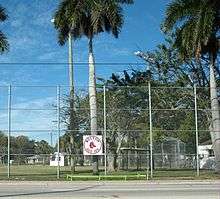
The Boston Red Sox hold their annual spring training at JetBlue Park in the Fort Myers area. A cross-town rivalry has developed with the Minnesota Twins, who conduct their spring training at Hammond Stadium in south Lee County, which has a capacity of 7,500 and opened in 1991.
The Red Sox' lease with Fort Myers runs through 2019, but the Red Sox were considering exercising the early out in their contract that would have allowed them to leave following the 2009 spring season. On October 28, 2008, the Lee County commission voted 3–1 to approve an agreement with the Boston Red Sox to build a new spring-training facility for the team in south Lee County. The new stadium, named JetBlue Park at Fenway South, is located off Daniels Parkway near Southwest Florida International Airport. The stadium opened in time for the 2012 Spring training season.
City of Palms Park had been built in 1992 for the Red Sox' spring training. Former Red Sox left fielder Mike Greenwell is from Fort Myers, and was instrumental in bringing his team to the city for spring training. The deal for JetBlue Park left City of Palms Park without a tenant. County officials have discussed the possibility of securing another team for City of Palms. Terry Park Ballfield (also known as the Park T. Pigott Memorial Stadium) in East Fort Myers is also not currently in use by a Major League Baseball team, though it is the former home of the Philadelphia Athletics, Cleveland Indians, Pittsburgh Pirates and Kansas City Royals.
Communities
Cities
Town
Village
Census-designated places
- Alva
- Boca Grande
- Bokeelia
- Buckingham
- Burnt Store Marina
- Captiva
- Charleston Park
- Cypress Lake
- East Dunbar
- Fort Myers Shores
- Gateway
- Harlem Heights
- Iona
- Lehigh Acres
- Lochmoor Waterway Estates
- Matlacha (on Matlacha Island)
- Matlacha Isles-Matlacha Shores
- McGregor
- North Fort Myers
- Olga
- Page Park
- Palmona Park
- Pine Island Center
- Pine Manor
- Pineland (on Pine Island)
- Punta Rassa
- San Carlos Park
- St. James City
- Suncoast Estates
- Tanglewood
- Three Oaks
- Tice
- Villas
- Whiskey Creek
- Babcock Ranch
See also
- National Register of Historic Places listings in Lee County, Florida
- Southwest Florida
- Sanibel-Captiva Chamber of Commerce
References
- 1 2 "State & County QuickFacts". United States Census Bureau. Retrieved February 14, 2014.
- ↑ "Find a County". National Association of Counties. Retrieved 2011-06-07.
- ↑ Publications of the Florida Historical Society. Florida Historical Society. 1908. p. 32.
- ↑ Gannett, Henry (1905). The Origin of Certain Place Names in the United States. U.S. Government Printing Office. p. 184.
- ↑ Jane Colihan "Spring Break," American Heritage, February/March 2006.
- ↑ "US Gazetteer files: 2010, 2000, and 1990". United States Census Bureau. 2011-02-12. Retrieved 2011-04-23.
- ↑ http://www.ncdc.noaa.gov/oa/documentlibrary/ewdcd/ewdstations-wmo.pdf
- ↑ It should be noted the NOAA document used classifies locations as warm as Newport News, Virginia as "continental", but areas with drastically more extreme climates, such as Wichita, Kansas as "sub-tropical".
- ↑ "Köppen Climate Classification Map:". Geophysical Institute of the University of Alaska, Department of Climate Science. Retrieved 2008-10-25.
- 1 2 3 "NowData – NOAA Online Weather Data". National Oceanic and Atmospheric Administration. Retrieved 2012-02-13.
- ↑ "Weather Variety – Annual Days With Thunderstorms". Weatherpages.com. Retrieved 2012-06-12.
- ↑ "County Totals Dataset: Population, Population Change and Estimated Components of Population Change: April 1, 2010 to July 1, 2015". Retrieved July 2, 2016.
- ↑ "U.S. Decennial Census". United States Census Bureau. Retrieved June 14, 2014.
- ↑ "Historical Census Browser". University of Virginia Library. Retrieved June 14, 2014.
- ↑ "Population of Counties by Decennial Census: 1900 to 1990". United States Census Bureau. Retrieved June 14, 2014.
- ↑ "Census 2000 PHC-T-4. Ranking Tables for Counties: 1990 and 2000" (PDF). United States Census Bureau. Retrieved June 14, 2014.
- 1 2 3 4 5 6 7 "Lee County: SELECTED SOCIAL CHARACTERISTICS IN THE UNITED STATES 2006-2010 American Community Survey 5-Year Estimates". factfinder.census.gov. Retrieved October 20, 2015.
- 1 2 3 "Lee County Demographic Characteristics". ocala.com. Retrieved October 23, 2015.
- ↑ "Lee County, Florida FIRST ANCESTRY REPORTED Universe: Total population - 2006-2010 American Community Survey 5-Year Estimates". factfinder.census.gov. Retrieved November 12, 2015.
- ↑ "Hispanic or Latino by Type: 2010 -- 2010 Census Summary File 1". factfinder.census.gov. Retrieved October 23, 2015.
- 1 2 "Lee County: Age Groups and Sex: 2010 - 2010 Census Summary File 1". factfinder.census.gov. Retrieved October 23, 2015.
- ↑ "Lee County, Florida: SELECTED ECONOMIC CHARACTERISTICS - 2006-2010 American Community Survey 5-Year Estimates". factfinder.census.gov. Retrieved November 18, 2015.
- 1 2 "Modern Language Association Data Center Results of Lee County, Florida". Modern Language Association. Retrieved October 23, 2015.
- ↑ Logan, Casey (June 8, 2015). "Fort Myers, Cape Coral technical institutes now colleges". News-Press. Retrieved 9 June 2015.
- ↑ "Commission on Colleges". Sacscoc.org. Retrieved March 31, 2013.
- ↑ "Lee County Library System". www.leegov.com. Retrieved 2016-03-19.
- ↑ http://www.fmb.lib.fl.us/
- ↑ Bennett Williams, Amy. "Reading, open house fundraiser at 1909 Alva Library". Retrieved 30 November 2015.
- ↑ Reaves, Gerri (2012). Legendary Locals of Fort Myers. Charleston SC: Legendary Locals. p. 84. ISBN 9781467100182.
- ↑ Lee County Library System. Lakes Regional Library. Web. Retrieved From: http://leelibrary.net/services/locations/LK/pages/default.aspx
- ↑ Lee County Library System. Fort Myers Regional Library. Web. Retrieved From: http://leelibrary.net/services/locations/FM/pages/default.aspx
- ↑ http://uselectionatlas.org/
- ↑ (PDF) http://www.flylcpa.com/uploads/pagesfiles/2001.pdf. Missing or empty
|title=(help) - ↑ "Market Ranks". Arbitron.com. Retrieved 2012-12-18.
- ↑ Retrieved from https://web.archive.org/web/20090523080340/http://www.nielsenmedia.com/nc/portal/site/Public/menuitem.3437240b94cacebc3a81e810d8a062a0/?vgnextoid=130547f8b5264010VgnVCM100000880a260aRCRD. Archived from the original on May 23, 2009. Retrieved December 12, 2015. Missing or empty
|title=(help). - ↑ 2013 NCAA MEN’S BASKETBALL ATTENDANCE. Retrieved March 29, 2014.
| Wikimedia Commons has media related to Lee County, Florida. |
 |
Charlotte County | Glades County | | |
| Gulf of Mexico | |
Hendry County | ||
| ||||
| | ||||
| Gulf of Mexico | Collier County |

Coordinates: 26°35′N 81°55′W / 26.58°N 81.92°W http://pineisland.info/index/surrounding-islands/cayo-costa/
http://www.news-press.com/story/life/130-years/2014/11/12/capt-pappy-padilla/18897925/