Cape Alexander, Greenland
| Cape Alexander | |
|---|---|
| Ullersuaq, Uvdlerssuak, Sarfalik | |
 | |
| Location | Qaasuitsup, Greenland |
| Coordinates | 78°11′N 73°3′W / 78.183°N 73.050°WCoordinates: 78°11′N 73°3′W / 78.183°N 73.050°W |
| Offshore water bodies | Baffin Bay |
| Area | Arctic |
Cape Alexander (Greenlandic: Ullersuaq, also Uvdlerssuak and Sarfalik; Danish: Kap Alexander) is a headland in the Baffin Bay, northwest Greenland, Qaasuitsup municipality. It is one of the important landmarks of Greenland.
Geography
Cape Alexander is located in Prudhoe Land, at the western end of Hartstene Bay with the Dodge Glacier to the east and Sutherland Island to the southeast.[1] It is the westernmost point of the island of Greenland.[2]
The small Carey Islands are located further to the west; among them Nordvestø (73°10'W) is the westernmost point of Greenland as a territory.[3]
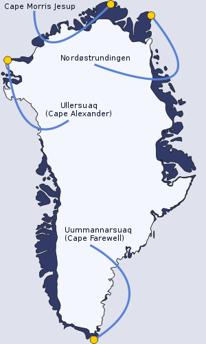 Ullersuaq amongst the extreme points of Greenland |
See also
References
- ↑ "Kap Alexander". Mapcarta. Retrieved 10 April 2016.
- ↑ Cape Alexander, Greenland at GEOnet Names Server
- ↑ 1:1,000,000 scale Operational Navigation Chart, Sheet B-8, 3rd edition
This article is issued from Wikipedia - version of the 5/29/2016. The text is available under the Creative Commons Attribution/Share Alike but additional terms may apply for the media files.