Cap de Creus


Cap de Creus (Catalan pronunciation: [ˈkab də ˈkɾɛws]) is a peninsula and a headland located at the far northeast of Catalonia, some 25 kilometres (16 mi) south from the French border. The cape lies in the municipal area of Cadaqués, and the nearest large town is Figueres, capital of the Alt Empordà and birthplace of Salvador Dalí. Cap de Creus is the easternmost point of Catalonia and therefore of mainland Spain and the Iberian Peninsula.
The area is now a Natural Park.[1]
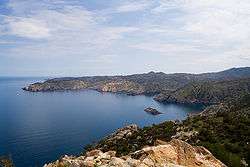
The peninsula has an area of 190 square kilometres (73 sq mi) of an extraordinary landscape value; a windbeaten very rocky dry region, with almost no trees, in contrast with a seaside rich in minuscule creeks of deep blue sea to anchor. Mountains are the eastern foothills of the Pyrenees, the natural border between France and Spain. The region is frequently swept by awful north wind "tramontana" (beyond mountains) which has caused many naval disasters. Cadaqués is the most well known village, home of artists and writers, with sophisticated atmosphere, near Port Lligat where Dalí built his home in a paradise small bay. (Dalí depicted the peninsula in his painting The Persistence of Memory.) El Port de la Selva, with a little fishing harbour, is less exploited, with good gastronomic recourses and pleasant terraces.
Sant Pere de Rodes stands out at 500 metres (1,600 ft) of altitude, with views of the Cap and the Pyrenees. It is an 11th-century monastery whose first structures date from about 750 AD.
One legend tells that the Cap de Creus was hewn by Hercules.
References
External links
Coordinates: 42°19′09″N 3°19′19″E / 42.31917°N 3.32194°E