Canyon Lake, Texas
| Canyon Lake, Texas | |
|---|---|
| CDP | |
 | |
| Nickname(s): The Water Recreation Capital of Texas | |
 Location of Canyon Lake, Texas | |
| Coordinates: 29°52′53″N 98°16′3″W / 29.88139°N 98.26750°WCoordinates: 29°52′53″N 98°16′3″W / 29.88139°N 98.26750°W | |
| Country | United States |
| State | Texas |
| County | Comal |
| Area | |
| • Total | 156.9 sq mi (406.3 km2) |
| • Land | 144.3 sq mi (373.6 km2) |
| • Water | 12.6 sq mi (32.7 km2) |
| Elevation | 965 ft (294 m) |
| Population (2000) | |
| • Total | 16,870 |
| • Density | 116.9/sq mi (45.2/km2) |
| Time zone | Central (CST) (UTC-6) |
| • Summer (DST) | CDT (UTC-5) |
| ZIP codes | 78130, 78132,78133 |
| Area code(s) | 830 |
| FIPS code | 48-12580[1] |
| GNIS feature ID | 1867545[2] |
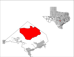
Canyon Lake is a census-designated place (CDP) in Comal County, Texas, United States. The population was 21,262 at the 2010 census. It is part of the San Antonio Metropolitan Statistical Area.
The Canyon Lake CDP includes a number of small, unincorporated communities surrounding Canyon Lake, including Sattler, Startzville, Canyon City, Cranes Mill, and Hancock. Communities located on the fringes of the CDP are Fischer, Spring Branch, and Smithson Valley.
Geography
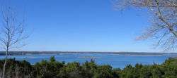
Canyon Lake, Texas is located at 29°52′53″N 98°16′03″W / 29.881462°N 98.267460°W.[3] It is located adjacent to Canyon Lake, from where it gets its name. It is located about 20 miles north-by-northwest of New Braunfels and about 40 miles north-by-northeast of Downtown San Antonio.
According to the United States Census Bureau, the CDP has a total area of 156.9 square miles (406 km2), of which, 144.3 square miles (374 km2) of it is land and 12.6 square miles (33 km2) of it (8.04%) is water.
Demographics
As of the census[1] of 2000, there were 16,870 people, 6,906 households, and 5,055 families residing in the CDP. The population density was 116.9 people per square mile (45.2/km2). There were 8,693 housing units at an average density of 60.3/sq mi (23.3/km2). The racial makeup of the CDP was 94.86% White, 0.31% African American, 0.57% Native American, 0.18% Asian, 0.03% Pacific Islander, 2.49% from other races, and 1.55% from two or more races. Hispanic or Latino of any race were 9.77% of the population.
There were 6,906 households out of which 27.0% had children under the age of 18 living with them, 62.0% were married couples living together, 7.5% had a female householder with no husband present, and 26.8% were non-families. 22.0% of all households were made up of individuals and 8.8% had someone living alone who was 65 years of age or older. The average household size was 2.44 and the average family size was 2.81.
In the CDP the population was spread out with 22.4% under the age of 18, 5.4% from 18 to 24, 26.6% from 25 to 44, 28.1% from 45 to 64, and 17.5% who were 65 years of age or older. The median age was 42 years. For every 100 females there were 98.9 males. For every 100 females age 18 and over, there were 97.3 males.
The median income for a household in the CDP was $42,019, and the median income for a family was $47,500. Males had a median income of $34,575 versus $25,268 for females. The per capita income for the CDP was $21,516. About 5.6% of families and 8.7% of the population were below the poverty line, including 14.4% of those under age 18 and 4.8% of those age 65 or over.
Education
Canyon Lake is served by the Comal Independent School District.[4]
Zoned schools:
- Bill Brown, Mountain Valley, Rebecca Creek, and Startzville elementaries[5]
- Most residents are zoned to Mountain Valley Middle School while a few are zoned to Smithson Valley Middle School[6]
- Most residents are zoned to Canyon Lake High School while a few are zoned to Smithson Valley High School[7]
Canyon Lake Gorge
On October 7, 2007, the Guadalupe-Blanco River Authority opened the 64-acre (260,000 m2) Canyon Lake Gorge, under a lease from the Army Corps of Engineers, with limited public tours. The 3-hour tours are booked 6 months in advance.[8]
Climate
The climate in this area is characterized by hot, humid summers and generally mild to cool winters. According to the Köppen Climate Classification system, Canyon Lake has a humid subtropical climate, abbreviated "Cfa" on climate maps.[9]
References
- 1 2 "American FactFinder". United States Census Bureau. Archived from the original on 2013-09-11. Retrieved 2008-01-31.
- ↑ "US Board on Geographic Names". United States Geological Survey. 2007-10-25. Retrieved 2008-01-31.
- ↑ "US Gazetteer files: 2010, 2000, and 1990". United States Census Bureau. 2011-02-12. Retrieved 2011-04-23.
- ↑ "2010 CENSUS - CENSUS BLOCK MAP (INDEX): Canyon Lake CDP, TX." U.S. Census Bureau. Retrieved on August 28, 2016.
- ↑ "Elementary School Attendance Zones" (Archive). Comal Independent School District. Retrieved on August 28, 2016. Zones: Bill Brown (Archive); Mountain Valley (Archive) - Rebecca Creek (Archive) - Startzville (Archive)
- ↑ "Middle School Attendance Zones" (Archive). Comal Independent School District. Retrieved on August 28, 2016. Mountain Valley Middle zone (Archive); Smithson Valley Middle zone (Archive)
- ↑ "High School Attendance Zones" (Archive). Comal Independent School District. Retrieved on August 28, 2016.Canyon Lake High HS zone (Archive) - Smithson Valley HS zone (Archive)
- ↑ Yahoo.com, Texas set to open new canyon to public Archived October 9, 2007, at the Wayback Machine.
- ↑ Climate Summary for Canyon Lake, Texas
External links
Municipalities and communities of Comal County, Texas, United States | ||
|---|---|---|
| Cities | 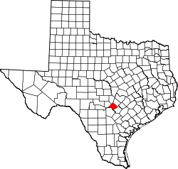 | |
| CDP | ||
| Unincorporated communities | ||
| Ghost town | ||
| Footnotes | ‡This populated place also has portions in an adjacent county or counties | |