Harvard Park, Los Angeles
Harvard Park is a 0.64-square-mile neighborhood in South Los Angeles, California, centered on a municipal park by that name. It is notable within the city for its relatively low household income, the high number of young people among its 10,000+ residents, its high average household size and the percentage of its families headed by single parents.[1]
Geography
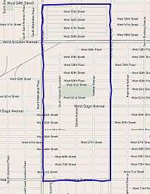
The Harvard Park neighborhood touches Vermont Square on the north, Vermont-Slauson on the east, Manchester Square on the south, and Chesterfield Square on the west.[2] It is bounded by West 54th Street on the north, Normandie Avenue on the east, Florence Avenue on the south and Western Avenue on the west.[1][3]
Adjacent neighborhoods
Relation of Harvard Park to other communities:[3][4]
 |
Vermont Square | | ||
| Chesterfield Square | |
Vermont-Slauson | ||
| ||||
| | ||||
| Manchester Square |
Population
A total of 10,297 residents lived in Harvard Park's 0.64 square miles, according to the 2000 U.S. census — averaging 16.072 people per square mile, among the highest population densities in both the city and the county. Its population has grown to 10,888, the city estimated in 2008.[1]
The median age was 28, young for the city and the county, and the percentages of residents younger than age 18 were among the county's highest. There were 504 families headed by single parents; the rate of 24.1% was considered high for both the city and the county.[1]
Within the neighborhood, black people made up 48.4% of the population, while Latinos were 48,2%. Other ethnicities were white, 1.1%; Asian, 0.6%; and other, 1.7%. Mexico and El Salvador were the most common places of birth for the 31.2% of the residents who were born abroad, about an average percentage for the city as a whole.[1]
The median household income in 2008 dollars was $37,013, considered low for both the city and county. The percentage of households earning $20,000 or less was high, compared to the county at large. The average household size of 3.3 people was also considered high. Renters occupied 49% of the housing units, and homeowners occupied the rest.[1]
Education
Only 3.6% of Harvard Park residents held a four-year degree, a low percentage for both the city and the county. The percentage of residents age 25 and older with less than a high school diploma was high for the county.[1]
There are no schools within the boundaries of the Harvard Park neighborhood.[5]
Recreation and parks
- Jackie Tatum/Harvard Recreation Center, 62nd Street between Harvard Boulevard and Halldale Avenue[3][6]
See also
References
- 1 2 3 4 5 6 7 "Harvard Park," Mapping L.A., Los Angeles Times
- ↑ "South Los Angeles," Mapping L.A., Los Angeles Times
- 1 2 3 The Thomas Guide: Los Angeles County, 2004, page 633
- ↑ "South L.A.," Mapping L.A. website of the Los Angeles Times
- ↑ "Harvard Park Schools," Mapping L.A., Los Angeles Times
- ↑ Los Angeles City Department of Parks and Recreation
External links
Coordinates: 33°58′58″N 118°18′14″W / 33.9829°N 118.3040°W