The Canongate
The Canongate is a district of Edinburgh, the capital city of Scotland. The name derives from the burgh of Canongate founded by David I of Scotland c.1143. It remained an autonomous burgh under its own administration until its incorporation into the adjacent growing city of Edinburgh, in 1856.
The district takes its name from the main street called Canongate (from Scots: Canongait) which forms the lower, eastern half of the Royal Mile in Edinburgh's historic Old Town. The eastern end is also sometimes referred to as the Holyrood area of the city. However, whilst Holyrood and Canongate derive their origin from the same source, Holyrood was a regality in its own right, independent of the Canongate.[1] The boundary is broadly analogous with the Holyrood Sanctuary or current precincts of the Palace (Watergate/Horse Wynd), having incorporated houses which once stood there.
The Canongate is named after the canons of Holyrood Abbey and the Scots word gait meaning "way" (echoed in the name of the pub on the street "The Canons' Gait").
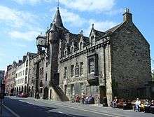
As well as the new Scottish Parliament building, which incorporates the historic Queensberry House, the Canongate contains some other notable public buildings, including Huntly House (now the Museum of Edinburgh) and the historic Canongate Tolbooth (now housing the People's Story Museum). In 1691 the Canongate Kirk was opened, replacing Holyrood Abbey as the parish church of the Canongate. The church is still used for Sunday services as well as weekday concerts.
Early History
The Canongate owes its existence primarily to the establishment of Holyrood Abbey in 1128. King David I, who established the Abbey, gave the surrounding area to the Augustinian canons then resident at Edinburgh Castle in the form of a regality.[2] The King also gave leave to the Canons to establish a burgh and as it was the only burgh within the regality it was given the status of burgh of regality of Canongate.[3][4] The area originally covered by the Canongate included the lands of Broughton, areas around the Pleasance and North Leith, giving the canons access to a port.[5] It is not clear from what point Holyrood and Canongate were established as separate jurisdictions, governed by their own magistrates, clerk, fiscal and other officers, but the evidence suggests some time before 1620.[6]
Holyrood Palace was developed from the 14th Century onwards as successive monarchs made increasing use of the Abbey for political events such as parliaments and royal councils. The word "Pallais" appears in a reference to the royal lodgings in the reign of James IV, but they were first converted to palace buildings by James V in 1525.[7]
The burgh of Canongate had a sometimes turbulent relationship with its neighbour, Edinburgh. The main reason for this was the continual battle over their exact boundaries up until their unification in 1856, an event which proved unpopular with the former's townsfolk.[8]
Because of the early historic connection between the Augustinian canons of Holyrood Abbey and their Church of St. Mary inside Edinburgh Castle, the parish of Canongate includes the Castle, hence a large common grave at the lower end of the churchyard was formerly used for soldiers of its garrison.
King James VI of Scotland's accession to the throne of England in 1603 began the long and slow decline of the Canongate. The loss of the royal court from the Palace of Holyroodhouse inevitably affected the wealth of the surrounding area. This was compounded by the union of the parliaments in 1707, as up until then Edinburgh had been the location of the Parliament of Scotland with the Canongate providing a fashionable suburb for the dwellings of the political class. The building of a new western approach to Edinburgh's New Town in the first decades of the 19th century effectively bypassed the area, causing even more neglect to the residential area which was gradually taken over by industrial premises including breweries and a large gasworks.
The Canongate was an important district during the Scottish Enlightenment partly because of the presence of the Canongate Theatre (1746-1786), of which one of the proprietors was Lord Monboddo. The philosopher David Hume performed in a play staged there.[9]
Writing in 1823, Robert Chalmers said of the Canongate, "As the main avenue from the palace into the city, it has born upon its pavements the burden of all that was beautiful, all that was gallant, all that has become historically interesting in Scotland for the last six or seven hundred years".[10]
Sir Walter Scott writing in 1827 stated; "Sir Sic itur ad Astra; This is the path to heaven. Such is the ancient motto attached to the armorial bearings of the Canongate, and which is inscribed, with greater or less propriety, upon all the public buildings, from the church to the pillory, in the ancient quarter of Edinburgh which bears, or rather once bore, the same relation to the Good Town that Westminster does to London".[11]
Modern Era

The area has seen various attempts at improvements and slum clearance, including a notable scheme by Sir Robert Hurd[12] started in the 1950s and completed by 1969, which included many new tenement blocks, some replicating their predecessor's facades and others blatantly of their time.
Due to the redevelopment of the 1950s/60s the once overcrowded and poverty-stricken area suffered from serious depopulation. From the 1980s onwards the Canongate area became notably less industrial, with many of the breweries closing, and residential redevelopment began. In the 1990s and 2000s, flats and offices were built on the former industrial land south of the main road, reversing the decline in population. Whilst much of this development has a modern appearance, some attempt has been made in terms of layout to retain the "fishbone" pattern characteristic of the Royal Mile.
As of 2006, the redevelopment of former industrial land to the north of the Canongate, once occupied by Victorian gasworks and a later bus garage, has proved controversial, partly due to the original proposal, now abandoned, to demolish some of the replacement buildings from the 1930s.
Above all, the construction of the new Scottish Parliament building on the site of the old Younger's Abbey Brewery has led to a resurgence of the area's vitality. For the first time since 1707 the Canongate has again become the centre of Scottish political life.
Education

The Royal Mile Primary School, formerly known as Milton House Public School, is a non-denominational state school that provides primary education for 5- to 11-year-old children. It was designed in 1886 by Robert Wilson, architect for the Edinburgh Board of Education.[13]
Within the school, there is also a nursery which caters for 3- to 5-year-old children. As the school is so central to the Canongate community, its pupils are often involved in illustrious events at the Scottish parliament and Edinburgh Castle. It is used as a polling station for the constituents of Edinburgh Central.[14]
The Canongate is also the location of Moray House, the Education department of the University of Edinburgh[15] (formerly Moray House College of Education). It comprises a number of buildings centred on St. John Street, some of which are historic, whilst others are purpose built. A number of other university buildings including the Pleasance student union building and the Centre for Sport and Exercise are located in the area historically covered by the Canongate.[16]
Historic crosses
There were three crosses in the main street of the Canongate.
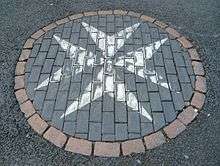
The ancient Mercat Cross (Market Cross) or Burgh Cross is shown on Gordon of Rothiemay's 1647 plan as being in the middle of the road nearly opposite the tolbooth. Gordon shows it as being similar to the Edinburgh Mercat Cross with the shaft and cross mounted on a stone gallery.[17] The much-altered cross now stands in the south-east corner of Canongate Churchyard to the right hand side of the entrance to Canongate Kirk. The St John's Cross used to stand further up the Canongate to the west.[18] and denoted the boundary between Edinburgh and the Canongate estate which in the Middle Ages was owned by the Knights of the Order of St John. The site is now marked by a maltese cross (55°57′04″N 3°10′54″W / 55.950975°N 3.181766°W), in the road surface near the top of St John's Street . It was known as St. John's Cross, because it stood on property belonging to the Knights of St. John, and it marked the ancient boundary of that part of the Royalty of Edinburgh which lay outwith the Netherbow Port and the city wall.[19][20]
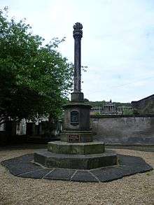
Where the Girth Cross, which has also been called the "Abbey" or "South" Cross at various times,[21] once stood is now marked by a radiating circle of setts (55°57′09″N 3°10′30″W / 55.95260°N 3.17492°W).[22] It marked the western limit of the Girth of Holyrood, "the greatest sanctuary in Scotland, and the last to disappear".[21] It is shown on a map of 1573 as an ornamental shaft elevated on a flight of steps and was not demolished until after 1767. In its shadow proclamations were read and executions were carried out. A notable execution took place next to the cross in 1600 when the young and beautiful Jean Kincaid (Lady Warriston) was beheaded by the Maiden for conspiring in the murder of her abusive husband.[22]
Coat of Arms

The coat of arms of the Canongate features a white hart's head and a golden cross, recalling the old legend in which King David I was saved from goring from a stag by the sudden appearance of a holy cross. The arms, though technically obsolete since the abolishment of the burgh of Canongate in 1856, can still be seen in many locations in and around the district, including on Edinburgh's mercat cross where they appear alongside the royal arms of Britain, Scotland, England and Ireland, the burgh arms of Edinburgh and Leith, and the arms of the University.
The motto is Sic itur ad astra meaning 'thus you shall go to the stars', a quote from Virgil's Aeneid.
Important Buildings
- Canongate Kirk 1691.
- Moray House, 1625, extended as Moray House College of Education.
- Queensberry House, 1686, now part of the Scottish Parliament.
- Canongate Tolbooth, now the People's Story Museum.
- Lodge Canongate Kilwinning Number 2 http://www.lck2.co.uk/ 1736, the oldest purpose built masonic lodge still used for its original purpose, officially "Lodge no. 2" attended by Robert Burns who was Invited to become their poet laureate.
- Chessel's Court, 1745.
- Morocco Land, a tenement of 1730 bearing the carved upper torso of a Moor.
- Shoemaker's Land, a tenement of 1725.
- Bible Land, a tenement of 1677.
- Huntly House, from 1517, now the Museum of Edinburgh.
- Whitefoord House, 1769, now the home of the Scottish Veterans Association.
- White Horse Close, a picturesque courtyard dating from around 1680 which served the Edinburgh-London coach and mailcoach route in the 18th century, restored in the early 1960s.
Famous Residents
- Oliver Cromwell stayed at Old Moray House during two periods of residence in Scotland
- James Douglas, 2nd Duke of Queensberry
- John Gay stayed at Queensberry House as guest of his patron, 3rd Duke of Queensberry
- Lord Milton
- Tobias Smollett lodged briefly at his sister's house above St. John's Pend
- Adam Smith lived in Panmure Close
- Lord Monboddo, whose house stood in St. John's Street
- Mary Paterson, one of Burke and Hare's victims, was murdered in Gibb's Close
- Sir William Wardlaw, 16th baronet lived at Chessels Court[23]
Literature
Walter Scott named Chronicles of the Canongate (1820s) after the area.
Notes
- ↑ John Mackay: History of the Burgh of Canongate (1900) p.209
- ↑ A Treatise On The History, Law, And Privileges Of The Palace And Sanctuary Of Holyrood House http://ia600504.us.archive.org/18/items/treatiseonhistor00halkiala/treatiseonhistor00halkiala_djvu.txt
- ↑ A Treatise On The History, Law, And Privileges Of The Palace And Sanctuary Of Holyrood House http://ia600504.us.archive.org/18/items/treatiseonhistor00halkiala/treatiseonhistor00halkiala_djvu.txt
- ↑ Dennison 2005, p. 4.
- ↑ Dennison 2005, p. 6.
- ↑ A Treatise On The History, Law, And Privileges Of The Palace And Sanctuary Of Holyrood House http://ia600504.us.archive.org/18/items/treatiseonhistor00halkiala/treatiseonhistor00halkiala_djvu.txt
- ↑ J Mackay, History of the Burgh of Canongate, Edinburgh 1886, p.7
- ↑ Susan Varga: Edinburgh Old Town (2006)
- ↑ Cloyd, E.L., James Burnett, Lord Monboddo (1972)
- ↑ Hamish Coghill, Edinburgh: The Old Town (1990)
- ↑ Chronicles of the Canongate|http://www.online-literature.com/walter_scott/chronicles-of-the-canongate/3/
- ↑ Buildings of Scotland: Edinburgh, by Colin McWilliam
- ↑ Buildings of Scotland, Edinburgh by Gifford McWilliam and Walker
- ↑ http://www.royalmileprimary.ik.org/ Royal Mile Primary School Official Website
- ↑ The Moray House School of Education. http://www.education.ed.ac.uk/
- ↑ University of Edinburgh Campus Map. http://www.ed.ac.uk/maps
- ↑ "Bird's eye view of Edinburgh in 1647 / by James Gordon of Rothiemay.". Town Plans / Views, 1580-1919. National Library of Scotland. Retrieved 2016-04-26.
- ↑ Best of Edinburgh Attractions 2006.
- ↑ Dennison 2005, p. 89.
- ↑ Royal Mile, St. John's Cross.
- 1 2 Canmore 1953.
- 1 2 Royal Mile, The old Girth Cross.
- ↑ http://digital.nls.uk/directories/browse/pageturner.cfm?id=83401971&mode=transcription
References
- "Edinburgh, Canongate, Girth Cross", Canmore, 25 December 1953, retrieved 13 September 2015
- Dennison, E. Patrica (2005), Holyrood and Canongate: A Thousand Years of History, Edinburgh: Birlinn, p. 89
- "Edinburgh-Royal Mile St. John's Cross". Royal Mile. Retrieved 13 September 2015.
- "The old Girth Cross". Royal Mile. Retrieved 13 September 2015.
- "A Walk Down the Royal Mile: The Canongate", Best of Edinburgh Attractions, 18 November 2006, retrieved 13 September 2015
External links

Coordinates: 55°56′59″N 3°10′34″W / 55.94965°N 3.176°W