Cabot, Bristol
| Cabot | |
 Shown within Bristol. |
|
| Population | 15,940 (2011.Ward)[1] |
|---|---|
| OS grid reference | ST575745 |
| Unitary authority | Bristol |
| Ceremonial county | Bristol |
| Region | South West |
| Country | England |
| Sovereign state | United Kingdom |
| Post town | BRISTOL |
| Postcode district | BS1 |
| Dialling code | 0117 |
| Police | Avon and Somerset |
| Fire | Avon |
| Ambulance | South Western |
| EU Parliament | South West England |
| UK Parliament | Bristol West |
Coordinates: 51°28′04″N 2°36′48″W / 51.4678°N 2.6132°W
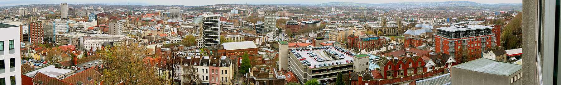
Cabot is a council ward that covers the centre of Bristol. It gets its name from the Cabot Tower – a memorial tower on Brandon Hill that was built to commemorate John Cabot's voyage and "discovery" of North America.
.jpg)
Areas
This ward contains the whole of the medieval city and many of the oldest surviving buildings. Cabot includes Bristol's Docks, the City Centre and the University of Bristol. Cabot has at least 17 churches, a cathedral, a synagogue, four museums, three hospitals, two theatres, two concert halls, and art galleries and cinemas.
Cabot includes: Spike Island, Baltic Wharf, Redcliffe Hill, Queen Square, Baldwin St, the City Centre, the Old City, Broadmead, Canon's Marsh, Brandon Hill, Park St, Bristol University, Kingsdown, Dove St, the east side of Whiteladies Road, the south side of Cotham Hill and Cotham Brow, and the west side of Stokes Croft.[2]
The area that comprises Brandon Hill, Park St, the Triangle, and the area between Park Row and the Hippodrome has been promoted under the name "The West End". Spike Island is the land between the Floating Harbour and the river Avon; from the digging of the "New Cut" until the Bathurst locks were sealed up it was literally an island.[3]
Bristol city centre
The central area of the city of Bristol, South West England, is the area south of the central ring road and north of the Floating Harbour, bordered north by St Pauls and Easton, east by Temple Meads and Redcliffe, and west by Clifton and Canon's Marsh. It is contained entirely within the Council ward of Cabot.[4]
Canon's Marsh

Canon's Marsh is an inner city area of Bristol, England, of approximately one square kilometre. Canon's Marsh is situated on the north side of Floating Harbour, immediately to the west of the River Frome spur (St Augustine's Reach) of the harbour. Canon's Marsh borders Hotwells to the west, Clifton to the north, and the city centre to the north east. Canon's Marsh was a shipbuilding area until the last yard closed in 1904, incorporating two of Teast's Docks, and including J&W Peters shipyard.
Canon's Wharf was once one of the busiest quays in the docks, with its own branch of the Bristol Harbour Railway, cranes and a goods shed. The area was also the location of the city gas works. With the decline of industry throughout the 20th century Canon's Marsh was cleared to make way for urban renewal. Due to pollution, however, the gas works remained derelict for several years. The area is now the location of At-Bristol, the South West offices of Lloyds TSB bank, a campus of City of Bristol College and several bars, restaurants, apartment buildings and offices.
Kingsdown
Kingsdown is a mainly residential area of Bristol, located to the north of the city centre and south of Cotham. It lies within the Cabot council ward.
Redcliffe
A small portion of the Redcliffe area lies within the Cabot ward. Most of it however lies in the Lawrence Hill ward.
Spike Island
Spike Island is the narrow strip of land between the Floating Harbour to the north and the tidal New Cut of the River Avon to the south, from the dock entrance to the west to Bathurst Basin in the east.
Tyndall's Park
Tyndall's Park is an area to the east of Clifton. It contains the main precinct of the University of Bristol, Bristol Grammar School and the BBC Bristol studios.
Statistics
In the 2001 Census Cabot ward:[5] had a resident population of 9,604. The population of Cabot is generally young, student/professional and in rented accommodation. The ward is in the Parliamentary constituency of Bristol West (held by Stephen Williams), and has two City Councillors: Mark Wright and Alex Woodman.[6] As of 2009/10, Cabot had the highest crime rate per resident of any ward in the city, more than double the offences per head of any other ward.[7]
References
- ↑ "Cabot" (PDF). 2011 Census Ward Information Sheet. Retrieved 26 February 2015.
- ↑ "Cabot Polling Districts" (PDF). Bristol City Council. Retrieved 15 December 2015.
- ↑ "Conservation Area 17 City Docks Character Appraisal & Management Proposals" (PDF). Bristol City Council. Retrieved 15 December 2015.
- ↑ "Bristol ward in focus: Cabot". Bristol Post. 13 May 2009. Retrieved 15 December 2015.
- ↑ Bristol City Council: Statistics and census information: Ward Finder and information about your ward including councillors, ward profiles and ward maps
- ↑ Bristol City Council: Councillors – surgeries: Councillor Finder – contact details, committee membership, surgeries, list of councillors
- ↑ "Crime: Total Offences" (PDF). Neighbourhood Partnership Statistical Profile 2011. Bristol City Council. Retrieved 27 October 2011.
External links
| Wikimedia Commons has media related to Cabot (Bristol ward). |