Canning Town
| Canning Town | |
 Royal Victoria Dock |
|
 Canning Town |
|
| Population | 30,806 (2011 Census. Canning Town North and South Wards)[1] |
|---|---|
| OS grid reference | TQ4081 |
| London borough | Newham |
| Ceremonial county | Greater London |
| Region | London |
| Country | England |
| Sovereign state | United Kingdom |
| Post town | LONDON |
| Postcode district | E16 |
| Dialling code | 020 |
| Police | Metropolitan |
| Fire | London |
| Ambulance | London |
| EU Parliament | London |
| UK Parliament | West Ham |
| London Assembly | City and East |
Coordinates: 51°30′54″N 0°01′34″E / 51.515°N 0.026°E
Canning Town is a district in East London, England. It is part of the London Borough of Newham and is situated in the area of the former London docks on the north side of the River Thames. It is the location of Rathbone Market. Despite being a neighbour to many affluent Dockland developments, Canning Town remains among the 5 per cent most deprived areas in the UK with many long term residents suffering from poor health, low education and poverty.
The area is currently undergoing significant regeneration. According to Newham borough council: 'The Canning Town and Custom House Regeneration Programme includes the building of up to 10,000 new homes, creation of thousands of new jobs and two improved town centres. This £3.7 billion project aims to transform the area physically, socially and economically.'[2]
History


Prior to the 19th century, the district was largely marshland, and accessible only by boat, or a toll bridge. In 1809, an Act of Parliament was passed for the construction of the Barking Road between the East India Docks and Barking. A five span iron bridge was constructed in 1810 to carry the road across the River Lea at Bow Creek. This bridge was damaged by a collision with a collier in March 1887 and replaced by the London County Council (LCC) in 1896. This bridge was in turn replaced in 1934,[3] at a site to the north and today's concrete flyover begun in smaller form in the 1960s, but successively modified to incorporate new road layouts for the upgraded A13 road and a feeder to the Limehouse Link tunnel, avoiding the Blackwall Tunnel. The abutments of the old iron bridge have now been utilised for the Jubilee footbridge, linking the area to Leamouth, in the London Borough of Tower Hamlets, on the western bank of the Lea.

The area is thought to be named for the first Viceroy of India, Charles John Canning, who suppressed the Indian Mutiny about the time the district expanded. The population increased rapidly after the North London Line was built from Stratford to North Woolwich, in 1846. This was built to carry coal and goods from the docks; and when the passenger station was first built it was known as Barking Road.[4] Speculative builders constructed houses for the workers attracted by the new chemical industries established in the lower reaches of the River Lea, and for the nearby Thames Ironworks and Shipbuilding Company and Tate & Lyle refinery.[5]
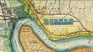
The opening of the Royal Victoria Dock in 1855 accelerated the development of the area[3] creating employment and a need to house dock workers and their families. New settlements around the dock developed, starting with Hallsville, Canning Town and Woolwich, and later the areas now known as Custom House, Silvertown and West Silvertown. The new settlements lacked water supply and had no sewage system, leading to the spread of cholera and smallpox.[6] The casual nature of employment at the docks meant poverty and squalid living conditions for many residents,[5] and in 1857 Charles Dickens wrote about the area:
"Canning Town is the child of the Victoria Docks. The condition of this place and of its neighbour prevents the steadier class of mechanics from residing in it. They go from their work to Stratford or to Plaistow. Many select such a dwelling place because they are already debased below the point of enmity to filth; poorer labourers live there, because they cannot afford to go farther, and there become debased. The Dock Company is surely, to a very great extent, answerable for the condition of the town they are creating. Not a few of the houses in it are built by poor and ignorant men who have saved a few hundred pounds, and are deluded by the prospect of a fatally cheap building investment."[7]
The industries around the dock were often unhealthy and dangerous. As trade unions and political activists fought for better living conditions and the dock area became the centre of numerous movements with Will Thorne, James Keir Hardie and other later becoming leading figures in the Labour Party.[6] From the late 19th century, a large African mariner community was established in Canning Town as a result of new shipping links to the Caribbean and West Africa.[8] In 1917 50 tons of TNT exploded at the Brunner Mond & Co ammunition work in Silvertown, causing the largest explosion in London's history and damaging more than 70,000 buildings and killing 73 people.[6] (see Silvertown explosion)
In the 1930s the County Borough of West Ham commenced slum clearances.[5] New houses, clinics, nurseries and a lido were opened. Silvertown ByPass and Britain's first flyover, the Silvertown Way, were built along with other new approach roads to the docks. Canning Town was heavily hit by the bombings in World War II and Canning Town Council's plan to rebuild the area focused on a reduction of the population, transferring industry and the building of new housing such as the Keir Hardie Estate, which included schools and welfare services.[6] The slum clearances and the devastation of World War II, destroying 85% of the housing stock, led to the preponderance of council estates that characterise the area today.[5] Post-war housing schemes followed the urban planning principles of the garden city movement. As demand for housing grew the first high rise buildings were built in Canning Town in 1961. In 1968 Ronan Point, a 22-storey tower block in Newham, collapsed and most of the tall tower blocks built in the area in the early 1960s were eventually demolished or reduced in size.[6]
Slum housing


Victorian era
In 1857 Charles Dickens published a detailed description of the area in Household Words entitled "Londoners over the Border", writing:
"...by the law there is one suburb on the border of the Essex marshes which is quite cut off from the comforts of the Metropolitan Buildings Act;-in fact, it lies just without its boundaries, and therefore is chosen as a place of refuge for offensive trade establishments turned out of the town, - those of oil boilers, gut spinners, varnish makers, printers ink makers and the like. Being cut off from the support of the Metropolitan Local Managing Act, this outskirt is free to possess new streets of houses without drains, roads, gas, or pavement."[7]
Describing the slum housing conditions and its effect on the health of local residents, Dickens wrote:
"Rows of small houses, which may have cost for their construction eighty pounds a piece, are built designedly and systematically with their backs to the marsh ditches; ...to or three yards of clay pipe "drain" each house into the open cess pool under its back windows, when it does not happen that the house is built as to overhang it... In winter time every block becomes now and then an island, and you may hear a sick man, in an upper room, complain of water trickling down over his bed. Then the flood cleans the ditches, lifting all their filth into itself, and spreading it over the land. No wonder that the stench of the marsh in Hallsville and Canning Town of nights, is horrible. A fetid mist covers the ground... the parish surgeon... was himself for a time invalided by fever, upon which ague followed. Ague, of course, is one of the most prevalent diseases of the district; fever abounds. When an epidemic comes into the place, it becomes serious in its form, and stays for months. Disease comes upon human bodies saturated with the influences of such air as is breathed day and night, as a spark upon touchwood. A case or two of small pox caused, in spite of vaccination, an epidemic of confluent small pox, which remained three or four months upon the spot."[7]
Dickens also describes efforts to improve the housing conditions in the area:
"Two years ago, when application was made by more than a tenth of the rate payers of the parish of West Ham for an inquiry into the sanitary condition of the district, with a view to bringing it under the conditions of the Public Health Act, Mr Alfred Dickens was the civil engineer sent by the general Board of Health as an inspector. His report and the evidence at his inquiry is before us as we write, and it dwells very much upon the state of Canning Town and Hallsville. We learn from this report that the area of the ditches in the parish amounted to not less than one hundred and fifty acres, according to a surveyors book upwards of thirty five years old, and that area has been increased by side cuttings at the railway and new cuttings of open sewer. Disease had cost the parish six hundred pounds in the year previous to the inquiry. There was then, of course, as now, no drainage or paving in Canning Town; the roads in winter were impassable; but the inhabitants were paying (for what they did not get) an eighteen penny rate under the Commissioners Act, not for works done in accordance with it, but "for the expenses of the act". Also, although the parish did not take charge of their roads, they were paying a highway rate for the parishioners elsewhere. One horrible detail in Mr Dickens report has, happily, to be omitted from our sketch. Two years ago, there was in Hallsville and Canning Town no water supply. Good water is now laid on. In all other respects, the old offences against civilised life cleave to the district. The local Board of Health which the inhabitants of the parish sought and obtained, whatever it may have done for Stratford, seems to have done nothing for Hallsville, unless it be considered something to indulge it with an odd pinch of deodorising powder."[7]
Alfred Dickens highlighted the severe overcrowding suffered by many of the slum inhabitants as a result of landlord charging high rents and households relying on casual work.[9]
20th century
The 1890 Housing Act made the local council responsible for providing decent accommodation and in the 1890s some of the first council houses were built in Bethell Avenue. However, many of the terraced houses built during the late 19th Century were little more than slums and cleared by the council in the 1930s. The council replaced the terraces with the first high rise blocks.[10]
Today
According to Newham London Borough Council Canning Town and Custom House are among the five percent most deprived areas in the UK. Residents suffer from poor health, low education and poverty. 17 percent of the working age population have a limiting long-term illness, 17.5 percent claim income support and 49.7 percent of 16- to 74-year-olds have no formal qualifications.[11]
Regeneration project
The consultation and governance mechanism of the currently ongoing regeneration project is underpinning by a partnership between councillors, residents, local businesses and other "partners".[11] According to Newham council:
"The views of residents and businesses is central to the development and delivery of the regeneration initiative and developers will be expected to continue with extensive community consultation and engagement as part of their remit."[11]
Newham council is currently attempting to encourage "re-interpretations" of London's established street and housing forms. The council has identified terraced housing as such housing form, stating that it "continues to have enduring popularity with all types of residents including families and children".[11]
The area is at the western end of the Thames Gateway zone and is currently undergoing a £1.7 billion regeneration project, which includes:
- demolishing 1,650 homes and building 8,000 new homes
- creating 500,000 square metres of floor-space in a revitalised town centre
- providing community facilities, including a library, a health centre
- undertaking improvements to primary schools
The Olympic Uniform Distribution and Accreditation Centre, which was located in Canning Town, was due to be demolished and replaced with a new industrial estate as part of the Olympic Legacy programme.[12]
Politics and local government
The area falls within the parliamentary constituency of West Ham.
In May 2006, voters in the Ward of Canning Town South returned three members of the Christian Peoples Alliance (including Alan Craig) as their elected Councillors. This was highly unusual in what is regarded as the rock-solid Labour borough of Newham. Labour regained the seats in 2010.
Rock and sport
The football team of the Thames Ironworks went on to become West Ham United F.C..
The Bridge House, a public house named for the 1887 Iron Bridge, was at 23 Barking Road – now demolished. The venue operated during the 1970s and 1980s and was host to The Police, Depeche Mode, Jeff Beck, Billy Bragg, Alexis Korner, Modern Romance, Sham 69, Lindisfarne, The Cockney Rejects, Iron Maiden, Remus Down Boulevard RDB and many other notable acts.[13] Recently, a new venue bearing the name The Bridge House2 has opened in Bidder Street.[14] Also on Barking Road, the former public house "The Royal Oak" (now an estate agent) had a boxing ring on the first floor. Amongst others, the boxer Frank Bruno trained there.
Education
Transport and locale
- Nearest places
- Nearest rail
The nearest London Underground station is Canning Town on the Jubilee line. It is also an interchange with the Docklands Light Railway.
Star Lane DLR station is situated in Canning Town North, on the junction of Manor Road and Star Lane, for trains running on the Stratford International branch. Royal Victoria DLR station is situated on Victoria Dock Road at the Royal Docks, for trains on the Beckton branch.
As of January 2016, all stations are in Zones 2/3.
References
- ↑ "Newham Wards population 2011".
- ↑ http://newham.gov.uk/InformationforBusinesses/RegenerationProjects/CanningTownAndCustomHouse.htm
- 1 2 West Ham: Rivers, bridges, wharfs and docks, A History of the County of Essex: Volume 6 (1973), pp. 57-61 accessed: 29 May 2008
- ↑ West Ham: Transport and postal services, A History of the County of Essex: Volume 6 (1973), pp. 61-63 accessed: 16 January 2008.
- 1 2 3 4 West Ham: Domestic buildings, A History of the County of Essex: Volume 6 (1973), pp. 50-57 accessed: 17 January 2008.
- 1 2 3 4 5 "The Royal Docks – a short history". Royal Docks Trust. Retrieved 28 June 2010.
- 1 2 3 4 Charles Dickens Londoners over the Border, Household Words – Volume XVI (1857)
- ↑ Geoffrey Bell, The other Eastenders : Kamal Chunchie and West Ham's early black community (Stratford: Eastside Community Heritage, 2002)
- ↑ Conditions in Canning Town in Victorian Times
- ↑ Housing in Canning Town in Victorian Times
- 1 2 3 4 "Canning Town and Custom House regeneration". Newham Council. 2009. Retrieved 2 December 2010.
- ↑ http://mgov.newham.gov.uk/documents/s52867/101%20Stephenson%20St%20Final%20Report.pdf
- ↑ Terence Murphy The Bridge House, Canning Town: Memoires of a Legendary Rock and Roll Hangout (2007)
- ↑ http://www.bh2live.com/
External links
| Wikimedia Commons has media related to Canning Town. |
- Canning Town: A deprived residential area with plans for regeneration
- Canning Town regeneration
- Canning Town Docks & Pubs History
- Canning Town Photo Archive
- History of Canning Town
- The Bridge House
- Frank Bruno at Royal Oak
- Kamal Chunchie - The Other Eastenders (Eastside Community Heritage)
- Ham: Domestic buildings', A History of the County of Essex: Volume 6 (1973)
| Districts |  | |
|---|---|---|
| Attractions | ||
| Sports | ||
| Markets | ||
| Parks and open spaces |
| |
| Constituencies | ||
| Tube, rail and DLR stations |
| |
| Other topics | ||