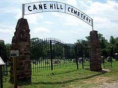
Cane Hill Cemetery
|
Canehill Cemetery | |
 | |
  | |
| Location | CR 13, Canehill, Arkansas |
|---|---|
| Coordinates | 35°54′50″N 94°23′55″W / 35.91389°N 94.39861°WCoordinates: 35°54′50″N 94°23′55″W / 35.91389°N 94.39861°W |
| Area | 5 acres (2.0 ha) |
| MPS | Canehill MRA |
| NRHP Reference # | [1] |
| Added to NRHP | November 17, 1982 |
The Cane Hill Cemetery is a cemetery in Canehill, Arkansas. It is located just south of Washington County Route 13 and west of Arkansas Highway 45.
History
The Cane Hill area was settled in the late 1820s. The cemetery contains the graves of two of its first settlers, Thomas Garvin (d. 1834) and Thomas Buchanan (d. 1836), and is the site of the community's first church and schoolhouse.[2] The Cane Hill area was the site of the Battle of Cane Hill, a running battle fought a few days before the Battle of Prairie Grove in November 1862. James G. Blunt and his Union troops captured approximately 2,000 Confederate soldiers in November 1862. The cemetery contains many Civil War-era burials.
The cemetery was listed on the National Register of Historic Places in 1982.[1]
See also
References
- 1 2 National Park Service (2009-03-13). "National Register Information System". National Register of Historic Places. National Park Service.
- ↑ "NRHP nomination for Cane Hill Cemetery" (PDF). Arkansas Preservation. Retrieved 2015-03-23.
| Topics | |
|---|---|
| Lists by states |
|
| Lists by insular areas | |
| Lists by associated states | |
| Other areas | |
| |