Canastota, New York
| Canastota, New York | |
|---|---|
| Village | |
|
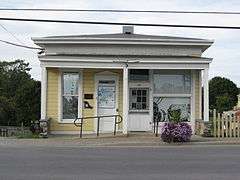
Judge Nathan Roberts House on NYS Route 5 | |
 Canastota, New York Location within the state of New York | |
| Coordinates: 43°4′51″N 75°45′13″W / 43.08083°N 75.75361°WCoordinates: 43°4′51″N 75°45′13″W / 43.08083°N 75.75361°W | |
| Country | United States |
| State | New York |
| County | Madison |
| Area | |
| • Total | 3.3 sq mi (8.6 km2) |
| • Land | 3.3 sq mi (8.6 km2) |
| • Water | 0.0 sq mi (0.0 km2) |
| Elevation | 430 ft (131 m) |
| Population (2010) | |
| • Total | 4,084 |
| Time zone | Eastern (EST) (UTC-5) |
| • Summer (DST) | EDT (UTC-4) |
| ZIP code | 13032 |
| Area code(s) | 315 |
| FIPS code | 36-12188 |
| GNIS feature ID | 0945755 |
.jpg)
Canastota is a village located inside the Town of Lenox in Madison County, New York, United States. The population was 4,084 at the 2010 census.
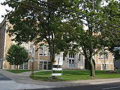
The village of Canastota is in the south part of the Town of Lenox. Canastota High School is located in the village.
History
Kniste Stota was the historic name of the village, a term used by the local Oneida Nation of the Iroquois Confederacy, meaning "cluster of pines near still waters". The village recently celebrated the bicentennial of its settlement by European-Americans.
One early historic property is the Judge Nathan S. Roberts House, which dates to about 1820.[1]

Canastota is well known as an "onion growing" town that at one point was a large portion of income in the village.
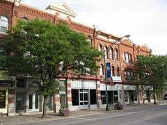
The village was incorporated in 1835, but was reorganized in 1870. Located along the banks of the Erie Canal, which was completed through the Mohawk River valley by 1825, Canastota was a vibrant trading and commerce town during the mid-nineteenth century for a wide agricultural area. When the canal was superseded by construction of railroads, and later the New York Thruway, some canal towns were cut off from the main lines of commerce.
Canastota is home of the International Boxing Hall of Fame. Having produced two world champions in Carmen Basilio and Billy Backus, Canastota was a natural choice as a site for the museum and outdoor stage. The museum is located a short distance from the New York State Thruway.
Each second weekend in June, Canastota has hosted numerous past and current champions, including Muhammad Ali, George Foreman and Joe Frazier. A Sunday parade and an induction ceremony is held to honor past and current Hall of Fame inductees.
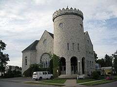
National Register of Historic Places
The following sites and historic districts are listed on the National Register of Historic Places.[2]

Geography
Canastota is located at 43°4′51″N 75°45′13″W / 43.08083°N 75.75361°W (43.080909, -75.753747).[5]
According to the United States Census Bureau, the village has a total area of 3.3 square miles (8.5 km2), all of it land.
Demographics
| Historical population | |||
|---|---|---|---|
| Census | Pop. | %± | |
| 1840 | 800 | — | |
| 1850 | 900 | 12.5% | |
| 1860 | 1,081 | 20.1% | |
| 1870 | 1,492 | 38.0% | |
| 1880 | 1,569 | 5.2% | |
| 1890 | 2,774 | 76.8% | |
| 1900 | 3,030 | 9.2% | |
| 1910 | 3,247 | 7.2% | |
| 1920 | 3,995 | 23.0% | |
| 1930 | 4,235 | 6.0% | |
| 1940 | 4,150 | −2.0% | |
| 1950 | 4,458 | 7.4% | |
| 1960 | 4,896 | 9.8% | |
| 1970 | 5,033 | 2.8% | |
| 1980 | 4,773 | −5.2% | |
| 1990 | 4,673 | −2.1% | |
| 2000 | 4,425 | −5.3% | |
| 2010 | 4,804 | 8.6% | |
| Est. 2015 | 4,661 | [6] | −3.0% |
As of the census[8] of 2000, there were 4,425 people, 1,872 households, and 1,173 families residing in the village. The population density was 1,332.3 people per square mile (514.6/km²). There were 1,994 housing units at an average density of 600.3 per square mile (231.9/km²). The racial makeup of the village was 97.31% White, 0.93% African American, 0.38% Native American, 0.29% Asian, 0.38% from other races, and 0.70% from two or more races. Hispanic or Latino of any race were 1.13% of the population.
There were 1,872 households out of which 29.6% had children under the age of 18 living with them, 45.9% were married couples living together, 11.9% had a female householder with no husband present, and 37.3% were non-families. 32.2% of all households were made up of individuals and 17.6% had someone living alone who was 65 years of age or older. The average household size was 2.36 and the average family size was 2.96.
In the village the population was spread out with 25.3% under the age of 18, 7.2% from 18 to 24, 28.7% from 25 to 44, 20.9% from 45 to 64, and 17.9% who were 65 years of age or older. The median age was 37 years. For every 100 females there were 88.1 males. For every 100 females age 18 and over, there were 86.7 males.
The median income for a household in the village was $34,155, and the median income for a family was $43,049. Males had a median income of $31,296 versus $24,047 for females. The per capita income for the village was $16,324. About 10.0% of families and 14.8% of the population were below the poverty line, including 19.5% of those under age 18 and 19.8% of those age 65 or over.
Notable people
- Carmen Basilio, former World Welterweight and Middleweight Champion
- Billy Backus, former World Welterweight Champion
- Milton De Lano, former US Congressman
- Margaret Shulock, cartoonist
References
- ↑ Naomi I. Klein (July 1983). "National Register of Historic Places Registration: Judge Nathan S. Roberts House". New York State Office of Parks, Recreation and Historic Preservation. Retrieved 2010-02-14.
- ↑ National Park Service (2009-03-13). "National Register Information System". National Register of Historic Places. National Park Service.
- ↑ Numbers represent an ordering by significant words. Various colorings, defined here, differentiate National Historic Landmarks and historic districts from other NRHP buildings, structures, sites or objects.
- ↑ The eight-digit number below each date is the number assigned to each location in the National Register Information System database, which can be viewed by clicking the number.
- ↑ "US Gazetteer files: 2010, 2000, and 1990". United States Census Bureau. 2011-02-12. Retrieved 2011-04-23.
- ↑ "Annual Estimates of the Resident Population for Incorporated Places: April 1, 2010 to July 1, 2015". Retrieved July 2, 2016.
- ↑ "Census of Population and Housing". Census.gov. Archived from the original on May 11, 2015. Retrieved June 4, 2015.
- ↑ "American FactFinder". United States Census Bureau. Archived from the original on 2013-09-11. Retrieved 2008-01-31.
External links
- Village of Canastota, New York
- Canastota Public Library Digital Collection on New York Heritage
- International Boxing Hall of Fame
- Canastota Little League
Municipalities and communities of Madison County, New York, United States | ||
|---|---|---|
| City | 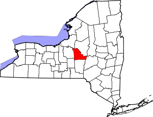 | |
| Towns | ||
| Villages | ||
| CDP | ||
| Other hamlets | ||
| Indian reservations | ||
| Footnotes | ‡This populated place also has portions in another county or counties | |