Canada–United States border
| Canada–United States border | |
|---|---|
 | |
| Characteristics | |
| Entities |
|
| Length | 8,891 kilometres (5,525 mi) |
| History | |
| Established | September 3, 1783 |
| Signing of the Treaty of Paris at the end of the American War of Independence | |
| Current shape | April 11, 1908 |
| Treaty of 1908 | |
| Treaties | Treaty of Paris, Jay Treaty, Treaty of 1818, Webster–Ashburton Treaty, Oregon Treaty |
| Notes | See list of current disputes |

The Canada–United States border (French: Frontière entre le Canada et les États-Unis), officially known as the International Boundary, is the longest international border in the world between two countries. It is shared between Canada and the United States, the second and fourth largest countries by area, respectively. The terrestrial boundary (including small portions of maritime boundaries on the Atlantic, Pacific, and Arctic coasts, as well as long stretches in the Great Lakes) is 8,891 kilometres (5,525 mi) long, of which 2,475 kilometres (1,538 mi) is with Alaska. Eight Canadian provinces and territories (Yukon, British Columbia, Alberta, Saskatchewan, Manitoba, Ontario, Quebec, and New Brunswick), and thirteen U.S. states (Alaska, Washington, Idaho, Montana, North Dakota, Minnesota, Michigan, Ohio, Pennsylvania, New York, Vermont, New Hampshire, and Maine) are located along the border.
History


The Treaty of Paris (1783)

The border originated with the Treaty of Paris in 1783, which ended the American Revolutionary War between Great Britain and the separating colonies which would form the United States. The 45th parallel was established as the border between Quebec and New York State (including what is now Vermont). The St. Lawrence River and the Great Lakes became the boundary further west (between what is now Ontario and the United States).
The Jay Treaty (1794)
The Jay Treaty of 1794 (effective 1796) created the International Boundary Commission, which was charged with surveying and mapping the boundary. It also provided for removal of British military and administration from Detroit and other frontier outposts on the U.S. side. It was superseded by the Treaty of Ghent (effective 1815) concluding the War of 1812, which included pre-war boundaries.
Rush–Bagot Treaty (1817)
The Rush–Bagot Treaty of 1817 provided a plan for demilitarizing the two combatant sides in the War of 1812 and also laid out preliminary principles for drawing a border between British North America (later Canada) and the United States.
The London Convention (1818)

Westward expansion of both British North America and the United States saw the boundary extended west along the 49th parallel from the Northwest Angle at Lake of the Woods to the Rocky Mountains under the Treaty of 1818. This treaty extinguished British claims south of that latitude to the Red River Valley, which was part of Rupert's Land. The treaty also extinguished U.S. claims to land north of that line in the watershed of the Missouri River, which was part of the Louisiana Purchase; this amounted to three small areas, consisting of the northern part of the drainages of the Milk River (today in southern Alberta and southwestern Saskatchewan), the Poplar River (Saskatchewan), and Big Muddy Creek (Saskatchewan).
Ashburton Treaty (1842)
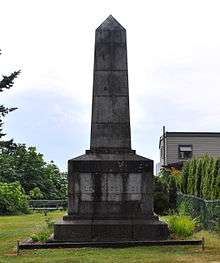
Disputes over the interpretation of the border treaties and mistakes in surveying required additional negotiations resulting in the Webster–Ashburton Treaty of 1842. The treaty resolved the dispute known as the Aroostook War over the boundary between Maine on the one hand, and New Brunswick and the Province of Canada on the other. The treaty redefined the border between New Hampshire, Vermont and New York on the one hand, and the Province of Canada on the other, resolving the Indian Stream dispute and the Fort Blunder dilemma at the outlet to Lake Champlain. The boundary along the 45th parallel had been surveyed after the War of 1812. The US Government began to construct fortifications just south of the border at Rouses Point on Lake Champlain. After a significant portion of the construction was completed, measurements revealed that at that point, the actual 45th parallel was three-quarters of a mile (1.2 km) south of the surveyed line; the fort, which became known as "Fort Blunder", was in Canada. This created a dilemma for the United States that was not resolved until a provision of the treaty left the border on the meandering line as surveyed. The border along the Boundary Waters in present-day Ontario and Minnesota between Lake Superior and the Northwest Angle was also redefined.[1][2]
The Oregon Treaty (1846)
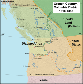
An 1844 boundary dispute during U.S. President James K. Polk's administration led to a call for the northern boundary of the U.S. west of the Rockies to be latitude 54° 40' north (related to the southern boundary of Russia's Alaska Territory), but the United Kingdom wanted a border that followed the Columbia River to the Pacific Ocean. The dispute was resolved in the Oregon Treaty of 1846, which established the 49th parallel as the boundary through the Rockies.
The Northwest Boundary Survey (1857–61)
The Northwest Boundary Survey (1857–61) laid out the land boundary, but the water boundary was not settled for some time. After the Pig War in 1859, arbitration in 1872 established the border between the Gulf Islands and the San Juan Islands.
The International Boundary Survey (1872–76)
The International Boundary Survey, called the Northern Boundary Survey in the United States, began in 1872.[3] Its mandate was to establish the border as agreed to in the Treaty of 1818. Archibald Campbell led the way for the United States. Donald Cameron headed the British team. This survey focused on the border from the Lake of the Woods to the summit of the Rocky Mountains.[4]
The Alaska boundary dispute (1903)
In 1903 a joint United Kingdom – Canada – U.S. tribunal established the boundary with Alaska, much of which follows the 141st meridian west.
The Treaty of 1908
On April 11, 1908, the United Kingdom and the United States agreed, under Article IV of the Treaty of 1908, to survey and delimit the boundary between Canada and the United States through the St. Lawrence River and Great Lakes, in accordance with modern surveying techniques, and thus accomplished several changes to the border.[5][6]
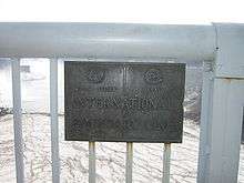
International Boundary Commission (1925)

In 1925, the International Boundary Commission was made a permanent organization responsible for surveying and mapping the boundary, maintaining boundary monuments (and buoys where applicable), as well as keeping the boundary clear of brush and vegetation for 6 metres (20 ft). This "border vista" extends for 3 metres (9.8 ft) on each side of the line. Along the 49th parallel, the border vista is theoretically straight but in practice follows the 19th century surveyed border markers and varies by several hundred feet in spots.[7]
The Commission's annual budget is about US$1.4 million.[8]
The Commission is headed by two commissioners, one of whom is Canadian, the other American.[9] In July 2007, the Bush administration relieved U.S. Commissioner Dennis Schornack of his post in connection with a dispute between the boundary commission and the U.S. government over private construction near the border.[10] Schornack rejected the dismissal, saying that the commission is an independent, international organization outside the U.S. government's jurisdiction, and that according to the 1908 treaty that created it, a vacancy can only be created by "the death, resignation or other disability" of a commissioner.[11] The Canadian government said that it was taking no position on the matter,[12] but Peter Sullivan, the Canadian commissioner, said on July 13 that he was ready to work with David Bernhardt, a Colorado-based solicitor of the Department of the Interior, who was designated as the acting U.S. commissioner by President Bush.[13]
Security
Law enforcement approach
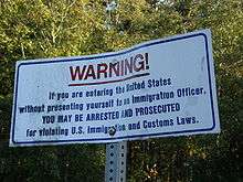

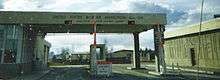
The International Boundary is commonly referred to as the world's longest undefended border, but this is true only in the military sense, as civilian law enforcement is present. It is illegal to pass the border outside border controls. Everyone passing the border must be checked. The relatively low level of security measures stands in contrast to that of the United States – Mexico border (one-third as long as the Canada–U.S. border), which is actively patrolled by U.S. customs and immigration personnel to prevent illegal migration and drug trafficking.
Parts of the International Boundary cross through mountainous terrain or heavily forested areas, but significant portions also cross remote prairie farmland and the Great Lakes and Saint Lawrence River, in addition to the maritime components of the boundary at the Atlantic, Pacific, and Arctic oceans. The border also runs through the middle of the Akwesasne Nation and even divides some buildings found in communities in Vermont and Quebec whose construction pre-dated the border's delineation. On the Maine–New Brunswick border, it divides the Aroostook Valley Country Club.[14]
The actual number of U.S. and Canadian border security personnel is classified; there are in excess of 17,000 United States Border Patrol personnel on the Mexico–U.S. border alone.[15]
Following the September 11, 2001, terrorist attacks in the United States, security along the border was dramatically tightened by both nations in both populated and rural areas. Both nations are also actively involved in detailed and extensive tactical and strategic intelligence sharing.
As of December 2010, Canada and the United States are negotiating an agreement titled "Beyond the Border: A Shared Vision for Perimeter Security and Competitiveness" which would give the U.S. more influence over Canada's border security and immigration controls, and more information would be shared by Canada with the U.S.[16]
Security measures

Residents of both nations who own property adjacent to the border are required to report construction of any physical border crossing on their land to their respective governments, and this is enforced by the International Boundary Commission. Where required, fences or vehicle blockades are used. All persons crossing the border are required to report to the respective customs and immigration agencies in each country. In remote areas where staffed border crossings are not available, there are hidden sensors on roads and also scattered in wooded areas near crossing points and on many trails and railways, but there are not enough border personnel on either side to verify and stop coordinated incursions. There is no border zone;[17] the U.S. Customs and Border Protection routinely sets up checkpoints as far as 100 miles (160 km) into U.S. territory.[18][19]
Smuggling
Smuggling of alcoholic beverages ("rum running") was widespread during the 1920s, when Prohibition was in effect nationally in the United States and parts of Canada.
In more recent years, Canadian officials have complained of drug, cigarette, and firearms smuggling from the United States, while U.S. officials have complained of drug smuggling from Canada.
In July 2005, law enforcement personnel arrested three men who had built a 360-foot (110 m) tunnel under the border between British Columbia and Washington that they intended to use for smuggling marijuana, the first such tunnel known on this border.[20]
Cornwall, Ontario, experiences ongoing smuggling – mostly of tobacco and firearms from the United States – due to its location. The neighbouring Mohawk territory of Akwesasne straddles the Ontario–Quebec–New York borders, and its First Nations sovereignty prevents Ontario Provincial Police, Royal Canadian Mounted Police, Canada Border Services Agency, Canadian Coast Guard, United States Border Patrol, United States Coast Guard, and New York State Police from exercising jurisdiction over exchanges taking place within the territory.[21][22]
Western Hemisphere Travel Initiative (WHTI)
In late 2006, the United States Department of Homeland Security (DHS) announced a rule regarding new identification requirements for U.S. citizens and international travelers entering the U.S. Implemented on January 23, 2007, this final rule and first phase of the WHTI specifies six forms of identification—one of which is required in order to enter the U.S. by air: a valid passport, a passport card, a state enhanced driver's license (available in Michigan, New York, Vermont, Washington, British Columbia, Manitoba, Minnesota, Ontario, and Quebec[23]) per the Western Hemisphere Travel Initiative, or trusted traveler program card (NEXUS, FAST, or SENTRI); a valid Merchant Mariner Credential when traveling in conjunction with official maritime business; or a valid U.S. military identification card when traveling on official orders.[24][25][26]
Since June 2009, every traveller arriving via a land or sea port-of-entry (including ferries) has been required to present one of the above forms of identification to cross the border.
Border lengths
 |
 | |||||
| Rank | State | Length of border with Canada | Rank | Province/Territory | Length of border with the U.S. | |
|---|---|---|---|---|---|---|
| 1 | Alaska | 2,475 km (1,538 mi) | 1 | Ontario | 2,760 km (1,715 mi) | |
| 2 | Michigan | 1,160 km (721 mi) | 2 | British Columbia | 2,168 km (1,347 mi) | |
| 3 | Maine | 983 km (611 mi) | 3 | Yukon | 1,210 km (752 mi) | |
| 4 | Minnesota | 880 km (547 mi) | 4 | Quebec | 813 km (505 mi) | |
| 5 | Montana | 877 km (545 mi) | 5 | Saskatchewan | 632 km (393 mi) | |
| 6 | New York | 716 km (445 mi) | 6 | New Brunswick | 513 km (318 mi) | |
| 7 | Washington | 687 km (427 mi) | 7 | Manitoba | 497 km (309 mi) | |
| 8 | North Dakota | 499 km (310 mi) | 8 | Alberta | 298 km (185 mi) | |
| 9 | Ohio | 235 km (146 mi) | ||||
| 10 | Vermont | 145 km (90 mi) | ||||
| 11 | New Hampshire | 93 km (58 mi) | ||||
| 12 | Idaho | 72 km (45 mi) | ||||
| 13 | Pennsylvania | 68 km (42 mi) | ||||
Crossings and border straddling
Notable bridge/tunnel crossings
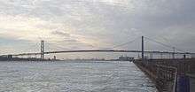

From west to east:
- Baudette – Rainy River International Bridge – Baudette, Minnesota, and Rainy River, Ontario
- Fort Frances–International Falls International Bridge – Fort Frances, Ontario, and International Falls, Minnesota
- Sault Ste. Marie International Bridge – Sault Ste. Marie, Michigan, and Sault Ste. Marie, Ontario
- Blue Water Bridge – Port Huron, Michigan, and Sarnia, Ontario
- St. Clair Tunnel
- Detroit–Windsor Tunnel – Windsor, Ontario, and Detroit, Michigan
- Michigan Central Railway Tunnel – Windsor, Ontario, and Detroit, Michigan
- Ambassador Bridge – Windsor, Ontario, and Detroit, Michigan
- Peace Bridge – Fort Erie, Ontario, and Buffalo, New York
- Rainbow Bridge – Niagara Falls, Ontario, and Niagara Falls, New York
- Whirlpool Rapids Bridge – Niagara Falls, Ontario, and Niagara Falls, New York
- Lewiston–Queenston Bridge – Queenston, Ontario, and Lewiston, New York
- Thousand Islands Bridge – Wellesley Island, New York, and Hill Island, Ontario
- Ogdensburg–Prescott International Bridge – Ogdensburg, New York, and Johnstown, Ontario
- Three Nations Crossing – Cornwall, Ontario, and Massena, New York
Other border crossings (airports, seaports, rail stations)
The U.S. maintains immigration offices, called pre-clearance facilities, in eight Canadian airports with international air service to the United States (Calgary, Edmonton, Halifax, Montreal, Ottawa, Toronto, Vancouver, and Winnipeg). This expedites travel by allowing flights originating in Canada to land at a U.S. airport without being processed as an international arrival. Canada does not maintain equivalent personnel at U.S. airports due to the sheer number of U.S. departure locations with Canadian-bound flights and the limited number of flights compared to the number of U.S.-bound flights that depart major Canadian airports.
Similar arrangements exist at major Canadian seaports that handle sealed direct import shipments into the U.S.
Additionally, at Vancouver's Pacific Central Station, passengers are required to pass through U.S. pre-clearance facilities and pass their baggage through an X-ray before being allowed to board the Seattle-bound Amtrak Cascades train, which makes no further stops before crossing the border. Pre-clearance facilities are not available for the popular New York City to Montreal (Adirondack) or Toronto (Maple Leaf) lines, as these lines have stops between Montreal or Toronto and the border. Instead, passengers must clear customs at a stop located at the actual border.
Ferry services operate between the province of New Brunswick and the state of Maine, as well as between the province of British Columbia and the states of Washington and Alaska. There are also several ferry services in the Great Lakes operating between the province of Ontario and the states of Michigan, New York, and Ohio. The ferry between Maine and Nova Scotia ended its route in 2009, but resumed operations in 2014.
Boldt Castle on Heart Island in the St. Lawrence River has a border control point on the island, but no specific location on the Canadian side. Canadians must present identification to land on the island.
Cross-border airports

One curiosity on the Canada–U.S. border is the presence of six airports that straddle the borderline. The airports were built prior to the U.S. entry into World War II as a way to legally transfer U.S-built aircraft such as the Lockheed Hudson to Canada under the provisions of the Lend-Lease Act. In the interest of maintaining neutrality, U.S. military pilots were forbidden to deliver combat aircraft to Canada. The aircraft were flown to the border, landed, and then at night towed on their wheels over the border by tractors or horses. The next day the planes were crewed by RCAF pilots and flown to other locations, typically airbases in Eastern Canada, from where they were often flown to the United Kingdom and deployed in the Battle of the Atlantic.[27]
Piney Pinecreek Border Airport is located in Manitoba and Minnesota. The northwest/southeast-oriented runway straddles the border, and there are two ramps; one in the U.S. and one in Canada. The airport is jointly owned by the Minnesota Department of Transportation and the local government of Piney, Manitoba. It is assigned U.S. identifier 48Y and Canadian identifier JX2.
International Peace Garden Airport is located in Manitoba and North Dakota adjacent to the International Peace Garden. The runway is entirely within North Dakota, but a ramp extends across the border to allow aircraft to access Canadian customs. While not jointly owned, it is operated as an international facility for customs clearance as part of the International Peace Garden.
Coronach/Scobey Border Station Airport is located in Saskatchewan and Montana. The east–west runway is sited exactly on the border. The airport is jointly owned by the Canadian and U.S. governments and is assigned U.S. identifier 8U3 and Canadian identifier CKK3.
Coutts/Ross International Airport is located in Alberta and Montana. Like Coronach/Scobey, the east–west runway is sited exactly on the border. It is owned entirely by the Montana Aeronautics Division. It is assigned U.S. identifier 7S8 and Canadian identifier CEP4.
Whetstone International Airport or Del Bonita/Whetstone International Airport is located in Alberta and Montana, and similarly has an east–west runway sited exactly on the border. It is assigned U.S. identifier H28 and Canadian identifier CEQ4.
Avey Field State Airport is located in Washington and British Columbia. The privately owned airfield is mostly in the U.S., but several hundred feet of the north–south runway extend into Canada, and both Canadian and U.S. customs are available. It is assigned U.S. identifier 69S but does not have a Canadian identifier.
Cross-border buildings

The Haskell Free Library and Opera House straddles the border in Derby Line, Vermont, and Stanstead, Quebec. Private homes are divided by the International Boundary line between Estcourt Station, Maine, and Pohénégamook, Quebec. Private homes between Beebe Plain, Quebec and Beebe Plain, Vermont; a seasonal home between Alburgh, Vermont, and Noyan, Quebec, at the intersection of Matthias Lane in Alburgh and Chemin au Bord du L'eau in Noyan; and one house between Richford, Vermont, and Abercorn, Quebec,[28] are also divided by the border.[29]
The Halfway House, a tavern also known as Taillon's International Hotel, straddles the border between Dundee, Quebec, and Fort Covington, New York.[30] It was built in 1820, before the border was surveyed.[31]
Boundary divisions
Practical exclaves
To be a true international exclave, all potential paths of travel from the exclave to the home country must cross over only the territory of a different country or countries. Like exclaves, practical exclaves are not contiguous with the land of the home country and have land access only through another country or countries. Unlike exclaves, they are not entirely surrounded by foreign territory. Hence, they are exclaves for practical purposes, without meeting the strict definition.
The term pene-exclave was defined in Robinson (1959) as "parts of the territory of one country that can be approached conveniently — in particular by wheeled traffic — only through the territory of another country."[32]:283 Pene-exclaves are also called functional exclaves or practical exclaves.[33]:31 Thus, a practical exclave has land borders with other territory but is not completely surrounded by the other's land or territorial waters.[34]:60 Catudal (1974)[35]:113 and Vinokurov (2007)[33]:31–33 further elaborate upon examples, including Point Roberts. "Although physical connections by water with Point Roberts are entirely within the sovereignty of the United States, land access is only possible through Canada."[35] Practical exclaves can exhibit continuity of state territory across territorial waters but, nevertheless, a discontinuity on land, such as in the case of Point Roberts.[33]:47
Practical exclaves of Canada
- Akwesasne: Because of the St. Lawrence River to the north, the Rivière-aux-Saumons to the east, and New York State, U.S., to the south, the Quebec portion of the Akwesasne reserve is a practical exclave of Canada. To travel by land from Tsi:Snaine (Snye or Chenail, Quebec) or Kana:takon (Saint Regis, Quebec) to elsewhere in Canada, one must drive through New York State.
- Campobello Island, located at the entrance to Passamaquoddy Bay, adjacent to the entrance to Cobscook Bay, and within the Bay of Fundy. The island is part of Charlotte County, New Brunswick, but is actually physically connected by the Franklin Delano Roosevelt Bridge with Lubec, Maine – the easternmost tip of the continental United States.
Practical exclaves of the United States
- The state of Alaska is bounded by British Columbia and Yukon, the Arctic Ocean, the Bering Sea, and the Pacific Ocean. (Additionally, because of the terrain, several municipalities in the "panhandle" are inaccessible by road except via Canada.)
- Point Roberts, Washington is bounded by British Columbia, the Strait of Georgia, and Boundary Bay.
- An uninhabited and unnamed peninsula in North Dakota is bounded by Manitoba and an unnamed lake west-by-northwest of the town of St. John, North Dakota and just south of Gunnville Lake in Manitoba.[36]
- Elm Point, Minnesota and two small pieces of uninhabited land (Buffalo Bay Point[37]) just to its west are bounded by Manitoba and Lake of the Woods.
- The Northwest Angle is bounded by Manitoba and Lake of the Woods.
- The Alburgh Tongue in Vermont is bounded by Quebec and Lake Champlain.[38][fn 1]
- Province Point in Vermont is bounded by Quebec and Lake Champlain.
Remaining boundary disputes
- Machias Seal Island and North Rock (Maine / New Brunswick)
- Dixon Entrance (Alaska / British Columbia)
- Beaufort Sea (Alaska / Yukon)
- Strait of Juan de Fuca (Washington / British Columbia)
See also
- American entry into Canada by land
- Borders of Canada
- Canada Border Services Agency
- Canada–United States relations
- Frozen River, a 2008 feature film about smuggling across the border
- Joseph Smith Harris' account of the Northwest Boundary Survey
- Indian barrier state, British plans to set up a new country in the Old Northwest
- List of Canada–United States border crossings
- Mexico–United States border
- United States Border Patrol
- United States Border Patrol interior checkpoints
- John Lewis Tiarks, British surveyor of the border
- Northwesternmost point of the Lake of the Woods
- Red River Colony
Footnotes
- ↑ However, this peninsula and the island to its south are connected by road bridges directly to the United States mainland, such that it is possible to make a through journey in and out of the Alburgh Tongue without entering Canada. This is not true of the other practical exclaves listed here.
References
Citations
- ↑ "British-American Diplomacy The Webster-Ashburton Treaty". Yale Law School. 1842. Retrieved March 1, 2007.
- ↑ Lass, William E. (1980). Minnesota's Boundary with Canada. St. Paul, Minnesota: Minnesota Historical Society. p. 2. ISBN 0-87351-153-0.
- ↑ McManus, Sheila (2005). The Line Which Separates: Race, Gender, and the Making of the Alberta-Montana Borderlands. Edmonton, Alberta: University of Alberta Press. p. 7. ISBN 0-88864-434-5.
- ↑ Campbell, Archibald; Twining, W. J. (1878). "Reports upon the survey of the boundary between the territory of the United States and the possessions of Great Britain from the Lake of the woods to the summit of the Rocky mountains". Authorised by an act of Congress approved March 19, 1872. Government Printing Office. Retrieved September 13, 2013.
- ↑ International Boundary Commission (1937). "Treaty of 1908 (included in Joint report upon the survey and demarcation of the boundary between the United States and Canada from the gulf of Georgia to the northwesternmost point of Lake of the woods. In accordance with the provisions of Articles VI and VII of the treaty signed at Washington April 11, 1908, and articles I, II, and IV of the treaty signed at Washington, February 24, 1925)". Washington, D.C.: U.S. Government Printing Office. p. 6. Retrieved June 18, 2015.
- ↑ International Waterways Commission (1915). "Report of the International Waterways Commission upon the International Boundary between the Dominion of Canada and the United States through the St. Lawrence River and Great Lakes as Ascertained and Re-established pursuant to Article IV of the Treaty between Great Britain and the United States signed 11th April 1908".
- ↑ "Canada & The United States (Bizarre Borders Part 2)". Retrieved June 21, 2013.
- ↑ Schiff, Stacy (July 22, 2007). "Politics Starts at the Border". New York Times.
- ↑ Organization Chart, International Boundary Commission, accessed July 27, 2007 Archived July 6, 2007, at the Wayback Machine.
- ↑ "Blaine couple, U.S. agency settle border wall case". Seattle Times. January 15, 2009.
- ↑ Bowermaster, David (July 12, 2007). "Firing by Bush rejected by boundary official". Seattle Times.
- ↑ Fong, Petti (July 26, 2007). "Politics delineates boundary dispute". Toronto Star.
- ↑ "Fired border official's job filled quickly: White House refuses comment on former bureaucrat involved in lawsuit over couple's fence". Globe and Mail. July 13, 2007.
- ↑ Aroostook Valley Country Club, Club History
- ↑ Jeffrey, Terence P. (September 24, 2009). "Administration Will Cut Border Patrol Deployed on U.S-Mexico Border". Cybercast News Service. Archived from the original on September 28, 2009. Retrieved September 25, 2009.
- ↑ Mark Kennedy, PostMedia News Political Time Bombs Litter Harper's Path, December 13, 2010
- ↑ "Common border zone proposed". Canadian Society of Customs Brokers. June 17, 2004. Retrieved July 12, 2013.
- ↑ Singel, Ryan (October 22, 2008). "ACLU Assails 100-Mile Border Zone as 'Constitution-Free' – Update". Wired.com. Retrieved July 12, 2013.
- ↑ Woodard, Colin (January 9, 2011). "Far From Canada, Aggressive U.S. Border Patrols Snag Foreign Students". Chronicle.com. Retrieved July 12, 2013.
- ↑ Frieden, Terry (July 22, 2006). "Drug tunnel found under Canada border: Five arrests made after agents monitored construction". CNN.com. CNN.
- ↑ Royal Canadian Mounted Police, "Fifteen People Arrested for Possession of Contraband Tobacco during High Intensity Enforcement Project", press release, February 25, 2009 Archived June 15, 2011, at the Wayback Machine.
- ↑ Cockburn, Neco (November 21, 2008). "Smuggling's price". Ottawa Citizen.
- ↑ "WHTI: Enhanced Drivers License". Getyouhome.gov. June 1, 2009. Retrieved April 30, 2014.
- ↑ "DHS Announces Final Western Hemisphere Air Travel". Association of Cotpotrate Travel Executives. December 5, 2006. Retrieved December 2, 2007.
- ↑ "Western Hemisphere Travel Initiative: The Basics". U.S. Department of Homeland Security. Archived from the original on December 26, 2007. Retrieved December 2, 2007
- ↑ "Western Hemisphere Travel Initiative". U.S. Department of State, Bureau of Consular Affairs. January 13, 2008. Retrieved January 12, 2007
- ↑ Places to Fly – Dunseith / International Peace Garden. Archive.copanational.org (June 8, 2007). Retrieved on July 12, 2013.
- ↑ Google (April 30, 2014). "1000 Drew Rd – Richford Vermont" (Map). Google Maps. Google. Retrieved April 30, 2014.
- ↑ Farfan, Matthew (2009). The Vermont-Quebec Border: Life on the Line. Arcadia Publishing. ISBN 0738565148
- ↑ "Wikimapia". Wikimapia. Retrieved April 30, 2014.
- ↑ Taillon's International Hotel, Taillon's International Hotel – straddling the US–Canada border!
- ↑ Robinson, G. W. S. (September 1959). "Exclaves". Annals of the Association of American Geographers. 49 (3, [Part 1]): 283–295. doi:10.1111/j.1467-8306.1959.tb01614.x. JSTOR 2561461.
- 1 2 3 Vinokurov, Evgeny (2007). The Theory of Enclaves. Lexington Books, Lanham, MD.
- ↑ Melamid, Alexander (1968). Sills, David, ed. "Enclaves and Exclaves". International Encyclopedia of the Social Sciences. 5. The Macmillan Company & Free Press.
Contiguous territories of states which for all regular commercial and administrative purposes can be reached only through the territory of other states are called pene-enclaves (pene-exclaves). These have virtually the same characteristics as complete enclaves (exclaves).
- 1 2 Catudal, Honoré M. (1974). "Exclaves". Cahiers de géographie du Québec. 18 (43): 107–136. doi:10.7202/021178ar.
- ↑ "Exclave of the United States in North Dakota – Wikimapia". wikimapia.org. Retrieved August 28, 2015.
- ↑ "Buffalo Bay Point". Google Maps. Retrieved June 19, 2016.
- ↑ "Google Maps". Retrieved July 30, 2014.
Further reading
- Anderson, Christopher G. Canadian Liberalism and the Politics of Border Control, 1867–1967 (University of British Columbia Press; 2012) 280 pages; studies pivotal episodes in Canadian immigration policy that shed light on more restrictive approaches today.
- Paulus, Jeremy and Asgary, Ali. (2010) Enhancing Border Security: Local Values and Preferences at the Blue Water Bridge (Point Edward, Canada) Journal of Homeland Security and Emergency Management: Vol. 7 : Iss. 1, Article 77.
- Culture and the Canada–US Border, an international research network dedicated to studying cultural representation, production and exchange on and around the Canada–US border.
External links
-
 Media related to Canada–United States border at Wikimedia Commons
 - International Boundary Commission
- 1994 trip from Lake of the Woods to the Continental Divide
| History |
| ||||||
|---|---|---|---|---|---|---|---|
| Provinces and territories |
| ||||||
| Government | |||||||
| Politics | |||||||
| Geography |
| ||||||
| Economy | |||||||
| Society | |||||||
| Demographics |
| ||||||
| Culture | |||||||
| Symbols | |||||||
| Article overviews | |||||||
| Research | |||||||
| |||||||