Campobello di Licata
Not to be confused with Campobello di Mazara.
| Campobello di Licata | |
|---|---|
| Comune | |
| Comune di Campobello di Licata | |
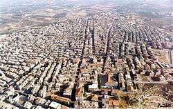 | |
 Campobello di Licata Location of Campobello di Licata in Italy | |
| Coordinates: 37°15′N 13°55′E / 37.250°N 13.917°ECoordinates: 37°15′N 13°55′E / 37.250°N 13.917°E | |
| Country | Italy |
| Region | Sicily |
| Province / Metropolitan city | Province of Agrigento (AG) |
| Area | |
| • Total | 80.9 km2 (31.2 sq mi) |
| Elevation | 316 m (1,037 ft) |
| Population (Dec. 2004) | |
| • Total | 10,647 |
| • Density | 130/km2 (340/sq mi) |
| Demonym(s) | Campobellesi |
| Time zone | CET (UTC+1) |
| • Summer (DST) | CEST (UTC+2) |
| Postal code | 92023 |
| Dialing code | 0922 |
| Website | Official website |
Campobello di Licata (Sicilian: Campubbeddu) is a comune (municipality) in the Province of Agrigento in the Italian region Sicily, located about 110 kilometres (68 mi) southeast of Palermo and about 30 kilometres (19 mi) east of Agrigento. As of 31 December 2004, it had a population of 10,647 and an area of 80.9 square kilometres (31.2 sq mi).[1]
History
In the 11th century, the Castello di Bifar was built in Campobello di Licata. It was destroyed in the earthquake of 1693.[2]
Geography
Campobello di Licata borders the following municipalities: Licata, Naro, Ravanusa and Canicattì.
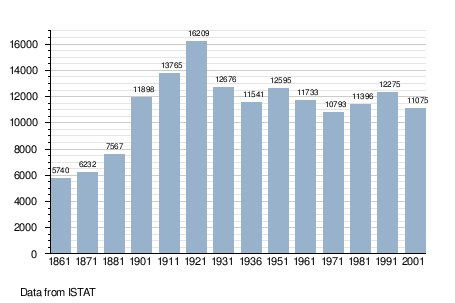
Demographic evolution
Famous Residents
- Salvatore Sanfilippo (creator of Redis)
References
- ↑ All demographics and other statistics: Italian statistical institute Istat.
- ↑ Cimino, Francesco. "Castello Di Bifar". iCastelli.it (in Italian). Retrieved 22 August 2015.
External links
![]() Media related to Campobello di Licata at Wikimedia Commons
Media related to Campobello di Licata at Wikimedia Commons
This article is issued from Wikipedia - version of the 8/28/2015. The text is available under the Creative Commons Attribution/Share Alike but additional terms may apply for the media files.